Expedició Palliser
| ||||
| ||||
| Tipus | expedició científica  | |||
|---|---|---|---|---|
| Epònim | John Palliser | |||
| Interval de temps | 1857 - 1860 | |||
| Localització | Terra de Rupert (Imperi Britànic) Amèrica del Nord britànica (Regne de la Gran Bretanya) | |||
| Estat | Canadà | |||
| Participant | James Hector John Palliser (expedition leader (en) Eugène Bourgeau Thomas Blakiston John W. Sullivan Maskepetoon (en) | |||


L'expedició Palliser va ser una expedició britànica a les praderies de l'oest del Canadà que tingué lloc entre els anys 1857 a 1860 i que va ser dirigida per John Palliser.
Participants
Entre els participants es trobaven:
- John Palliser, geògraf
- James Hector, geòleg i cirurgià
- Eugène Bourgeau, botànic
- Thomas Blakiston, encarregat de l'orientació amb la brúixola
- John W. Sullivan, matemàtic i observador de l'orientació amb el sextant
-
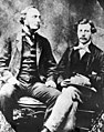 El capità John Palliser i James Hector
 -

-
 Thomas Wright Blakiston


Conclusions
Tres anys després de l'expedició, Palliser presentà el seu informe al Parlament britànic el 1863. Un mapa detallat de les regions visitades es va publicar el 1865. El Triangle de Palliser va ser explorat per primera vegada en aquesta expedició i van concloure que aquesta regió era massa seca per l'agricultura tot i que finalment va ser conreada però amb problemes per la secada de la dècada de 1930.
Bibliografia
- Palliser, John. Exploration - British North America: The journals, detailed reports, and observations relative to the exploration, by Captain Palliser, of that portion of British North America, which, in latitude, lies between the British boundary line and the height of land or watershed of the northern or frozen ocean respectively, and in longitude, between the western shore of Lake Superior and the Pacific Ocean during the years 1857, 1858, 1859, and 1860. Londres: G.E. Eyre and W. Spottiswoode, 1863.
- Palliser, John. Further papers relative to the exploration by the expedition under Captain Palliser of that portion of British North America which lies between the northern branch of the River Saskatchewan and the frontier of the United States; and between the Red River and the Rocky Mountains, and thence to the Pacific Ocean. Londres: G.E. Eyre and W. Spottiswoode, 1860.
- Palliser, John. Papers relative to the exploration by Captain Palliser of that portion of British North America which lies between the northern branch of the River Saskatchewan and the frontier of the United States; and between the Red River and Rocky Mountains. Londres: G.E. Eyre and W. Spottiswoode, 1859.
- Palliser, John. Progress of the British North American exploring expedition under the command of Capt. John Palliser, F.R.G.S., 1859.
