Ängbyplan metro station
Stockholm Metro station
59°20′30.8″N 17°54′26.6″E / 59.341889°N 17.907389°E / 59.341889; 17.907389| Preceding station |  Stockholm metro Stockholm metro | Following station | ||
|---|---|---|---|---|
| Islandstorget towards Hässelby strand | Line 19 | Åkeshov towards Hagsätra | ||
Location | |
|---|---|
 |
Ängbyplan metro station, formerly known as Färjestadsvägen metro station, is a station on the Green line of the Stockholm metro. It is located in the district of Södra Ängby, which is part of the borough of Bromma in the west of the city of Stockholm. The station is above ground and has a single island platform, with access from the underpass taking Färjestadsvägen under the line.[3][4] The distance to Slussen is 12.4 kilometres (7.7 mi).[1]
The station lies on the route of a line known as the Ängbybanan [sv] that formerly linked Alvik and Islandstorget. The Ängbybanan was designed and built for use by the future metro, but was operated from 1944 as part of line 11 of the Stockholm tramway. Ängbyplan station was inaugurated as part of the metro on 26 October 1952 with the conversion of the Ängbybanan and its extension to form the metro line between Hötorget and Vällingby.[3][5] It was called Färjestadsvägen until 1962.[1]
The metro station was decorated with tile in 1994 by Åsa Lindström [sv].[6]
Gallery
-
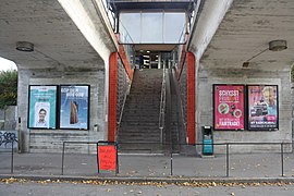 Station entrance, 2018
 -
 Ticket hall, 2018
 -
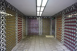 Tiled artwork, 2018


References
- ^ a b c Alfredsson, Björn; Berndt, Roland; Harlén, Hans (2000). Stockholm under: 50 år – 100 stationer (in Swedish). Stockholm: Bromberg. p. 59. ISBN 91-7608-832-4. SELIBR 7652820.
- ^ "Fakta om SL och regionen 2019" (PDF) (in Swedish). Storstockholms Lokaltrafik. p. 51. Archived (PDF) from the original on 27 December 2020. Retrieved 28 March 2021.
- ^ a b Schwandl, Robert. "Stockholm". urbanrail. Archived from the original on 23 April 2019. Retrieved 8 May 2019.
- ^ "Ängbyplan". Google maps. Retrieved 9 March 2022.
- ^ Jacobson, Per (1998). En spårväg till Bromma [A tramway to Bromma] (in Swedish). Oslo: Baneforlaget. ISBN 82-91448-25-6.
- ^ "Art in the Stockholm metro" (PDF). Stockholm Transport. Archived from the original (PDF) on 2009-02-05. Retrieved 2008-09-10.
- v
- t
- e

| Shared stations | |
|---|---|
| 17 | |
| 18 |
|
| 19 |


| Authority control databases: Geographic |
|
|---|
 | This article about a Swedish railway station is a stub. You can help Wikipedia by expanding it. |
- v
- t
- e
 | This Stockholm Metro article is a stub. You can help Wikipedia by expanding it. |
- v
- t
- e


