Červený Kláštor
Village in Slovakia
49°24′N 20°25′E / 49.400°N 20.417°E / 49.400; 20.417 Slovakia
 (2021)
059 06[3]
Červený Kláštor (Slovak pronunciation: [ˈtʂerʋeniː ˈklaːʂtɔr], Goral: Švaby) (lit. 'red monastery') is a small village and municipality in the far north Kežmarok District in the Prešov Region of northern Slovakia, near the Polish border, in the Zamagurie region.
History
A Camaldolese monastery was established on this location, then part of the Habsburg-ruled Kingdom of Hungary, in 1710.
In 1782, it was secularized as part of Emperor Joseph II's campaign against monastic orders that, in his view, didn't pursue useful activities. The monastery building still exists however (see photo).
The present village was founded in 1828.
Geography
The municipality lies at an altitude of 465 metres and covers an area of 3.043 km2. It has a population of about 222 people. It lies 8 km east of the centre of Zamagurie region, Spišská Stará Ves. The governing body of the Pieniny national park is located in the village. Dunajec river, which makes border with Poland, flows near the village. It is used for tourist purposes for rafting. Other attractions in or near the village include the Červený kláštor (spelled with a lower-case "k"; literally Red Monastery) or walking in the surrounding mountains of Pieniny. Since 2006, there is a new bridge for pedestrians in operation, connecting Červený Kláštor and Sromowce Niżne.
Gallery
-
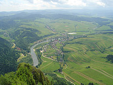 View of the village from the Polish Trzy Korony
 -
 Pedestrian bridge between Červený Kláštor and Sromowce Niżne in Poland


Genealogical resources
The records for genealogical research are available at the state archive "Statny Archiv in Levoča, Slovakia"
- Roman Catholic church records (births/marriages/deaths): 1766-1832 (parish B)
- Lutheran church records (births/marriages/deaths): 1809-1920 (parish B)
See also
References
- ^ "Počet obyvateľov podľa pohlavia - obce (ročne)". www.statistics.sk (in Slovak). Statistical Office of the Slovak Republic. 31 March 2022. Retrieved 31 March 2022.
- ^ a b "Hustota obyvateľstva - obce [om7014rr_ukaz: Rozloha (Štvorcový meter)]". www.statistics.sk (in Slovak). Statistical Office of the Slovak Republic. 31 March 2022. Retrieved 31 March 2022.
- ^ a b c d "Základná charakteristika". www.statistics.sk (in Slovak). Statistical Office of the Slovak Republic. 17 April 2015. Retrieved 31 March 2022.
- ^ a b "Hustota obyvateľstva - obce". www.statistics.sk (in Slovak). Statistical Office of the Slovak Republic. 31 March 2022. Retrieved 31 March 2022.
External links
- http://cervenyklastor.sk Official homepage
- Surnames of living people in Cerveny Klastor
- v
- t
- e
Municipalities of Kežmarok District
- Abrahámovce
- Bušovce
- Červený Kláštor
- Havka
- Holumnica
- Hradisko
- Huncovce
- Ihľany
- Javorina
- Jezersko
- Jurské
- Krížová Ves
- Lechnica
- Lendak
- Ľubica
- Majere
- Malá Franková
- Malý Slavkov
- Matiašovce
- Mlynčeky
- Osturňa
- Podhorany
- Rakúsy
- Reľov
- Slovenská Ves
- Spišské Hanušovce
- Stará Lesná
- Stráne pod Tatrami
- Toporec
- Tvarožná
- Veľká Franková
- Veľká Lomnica
- Vlková
- Vlkovce
- Vojňany
- Vrbov
- Výborná
- Zálesie
- Žakovce

Authority control databases | |
|---|---|
| International |
|
| National |
|
 | This Prešov Region geography article is a stub. You can help Wikipedia by expanding it. |
- v
- t
- e


