Avenida General Paz
Highway in Argentina
You can help expand this article with text translated from the corresponding article in Spanish. (May 2015) Click [show] for important translation instructions.
- View a machine-translated version of the Spanish article.
- Machine translation, like DeepL or Google Translate, is a useful starting point for translations, but translators must revise errors as necessary and confirm that the translation is accurate, rather than simply copy-pasting machine-translated text into the English Wikipedia.
- Do not translate text that appears unreliable or low-quality. If possible, verify the text with references provided in the foreign-language article.
- You must provide copyright attribution in the edit summary accompanying your translation by providing an interlanguage link to the source of your translation. A model attribution edit summary is
Content in this edit is translated from the existing Spanish Wikipedia article at [[:es:Avenida General Paz]]; see its history for attribution. - You may also add the template
{{Translated|es|Avenida General Paz}}to the talk page. - For more guidance, see Wikipedia:Translation.
| National Route A001 | |
|---|---|
| Ruta nacional A001 | |
| Avenida General Paz | |
 | |
| Route information | |
| Maintained by Autopistas del Sol | |
| Length | 32 km (20 mi) |
| Existed | 1941–present |
| Major junctions | |
| Beltway around Buenos Aires | |
| West end | Almirante Brown Avenue and Pinzón Street |
| East end | Avenida Leopoldo Lugones |
| Location | |
| Country | Argentina |
| Highway system | |
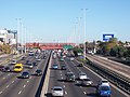
Avenida General Paz (official name Ruta Nacional A001 - National Route A001) is a beltway freeway surrounding the city of Buenos Aires. Roughly following the boundary between the city and Buenos Aires Province, it is one of the few motorways in Argentina that is toll-free. It carries three lanes of traffic in each direction during most of its length, and five lanes between the Pan-American Highway and the Río de la Plata. There are feeder roads in both directions and there are service areas along its length, usually with a gas station and fast food restaurants.
The route was the first highway in Argentina, built between 1937 and 1941 with a cost of m$n 24 million, and officially inaugurated on July 5, 1941.[1]
History

Federal law number 2,089 of 1887 established the limits of the city of Buenos Aires, including the partidos of Belgrano and the former San José de Flores (now Barrio Flores). In Article 6 of that law it declared that a road was to be built to delimit these with the city of Buenos Aires. Due to the plan of drawing straight lines for the road, an exchange of land was made between the Autonomous City of Buenos Aires and Buenos Aires Province.
Named after José María Paz, the freeway was designed by Pascual Palazzo and construction was directed by José María Zaballa Carbó. It was the first freeway built in the country. The crossings with the most important avenues were grade-separated; more minor cross-streets were served with traffic circles. The road had four lanes, two on each direction and lateral feeder streets of one lane on each side. The pavement was made of reinforced concrete.
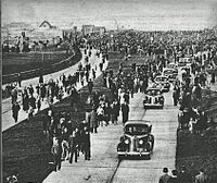
Works started on 8 June 1937, completed in two stages, the first from Riachuelo to Liniers (to Ramón Falcón street). The second stage extended from Liniers to Río de la Plata. Works were supervised by Dirección Nacional de Vialidad (the National office that controlled the routes in the country) and carried out by three private companies, "Empresa Argentina de Cemento Armado", "Compañía de Construcciones Civiles S.A.", and "Empresa Sabaría y Garassino Ltda." The freeway was opened to the public on 5 July 1941.[1]
In the 1970s the roundabout on Avenida del Libertador was replaced by an interchange.
In 1996 the road was modernized and fully grade-separated, widening the road to three lanes on each direction and two feeder streets with two lanes each. To facilitate traffic it was decided that the colectivo bus lines travelled on these feeder roads, except the express service buses, which stop on these feeders. These streets have speed bumps that limit speed to 40 kilometers per hour (25 mph).
Gallery
-
 The expressway at its junction with Highway 7
 -
 Avenida General Paz at its San Martín Avenue exit
 -


References
- ^ a b La avenida General Paz on Buenos Aires Historia
External links
Wikimedia Commons has media related to Avenida General Paz.
- (in Spanish) Buenos Aires government current and historical maps
- v
- t
- e
Landmarks of Buenos Aires City
historic buildings
and structures
- Cabildo
- Casa Rosada
- Chacarita Cemetery
- City Hall
- City Legislature
- Confitería del Molino
- Congress Palace
- Customs House
- CCK
- Duhau Palace
- Estrugamou Building
- Floralis Genérica
- Galerías Pacífico
- Immigrants' Hotel
- Kavanagh Building
- Libertador Building
- May Pyramid
- Metropolitan Cathedral
- Ministry of Public Works Building
- Monument to Giuseppe Garibaldi
- Obelisco
- Palacio de Aguas Corrientes
- Palacio Barolo
- Palacio Haedo
- Pizzurno Palace
- Plaza Hotel
- Recoleta Cemetery
- San Martín Palace
- Santo Domingo convent
- Sarmiento Frigate
- Torre Monumental
- Uruguay Corvette
- Women's Bridge
neighbourhoods
- Avellaneda Park
- Botanical Gardens
- Buenos Aires Eco-Park
- Buenos Aires Ecological Reserve
- Chacabuco Park
- Ciudad Universitaria
- Congressional Plaza
- Japanese Gardens
- Lezama Park
- Palermo Gardens
- Parque Centenario
- Parque de la Memoria
- Plaza Canadá
- Plaza Fuerza Aérea Argentina
- Plaza de la República
- Plaza de Mayo
- Plaza Intendente Alvear
- Plaza San Martín
Institutions
- Ateneo Bookshop
- Argentine Automobile Club
- Café Tortoni
- Cine Cosmos
- Foreign Debt Museum
- Fortabat Art Collection
- House of Culture
- Illuminated Block
- Isaac Fernández Blanco Museum
- King Fahd Cultural Center
- Latin American Art Museum
- Modern Art Museum
- Natural Sciences Museum
- National Library
- National Museum of Decorative Arts
- National Museum of Fine Arts
- National Museum of History
- Opera House
- Paz Palace
- Planetarium
- Recoleta Cultural Center
- Rojas Cultural Center
- San Martín Cultural Center
- San Martín National Institute
- Sarmiento Museum
- Eduardo Sívori Museum
- Fundacion Proa
- Argentinos Juniors Stadium
- Boca Juniors Stadium
- CeNARD
- Ferro C. Oeste Stadium
- GEBA Stadium
- Hippodrome of Palermo
- Huracán Stadium
- Lawn Tennis Club
- Luna Park Arena
- Malvinas Argentinas Arena
- Mary Terán de Weiss Tennis Stadium
- Nueva Chicago Stadium
- Obras Sanitarias Arena
- Polo Stadium
- Race Circuit
- River Plate Stadium
- San Lorenzo Stadium
- José Amalfitani Stadium
entertainment
and avenues
- Avenida 9 de Julio
- Avenida Alvear
- Avenida de Mayo
- Avenida del Libertador
- Belgrano Avenue
- Callao Avenue
- Caminito
- Córdoba Avenue
- Coronel Díaz Street
- Corrientes Avenue
- Figueroa Alcorta Avenue
- Florida Street
- General Paz Avenue
- President Julio Argentino Roca Avenue
- Leandro Alem Avenue
- Pueyrredón Avenue
- President Roque Sáenz Peña Avenue
- Rivadavia Avenue
- Santa Fe Avenue
- Sarmiento Avenue
- Scalabrini Ortiz Avenue
| |||||||||||||
|---|---|---|---|---|---|---|---|---|---|---|---|---|---|
| National |
|  | |||||||||||
| Provincial |
| ||||||||||||
| |||||||||||||

34°33′27″S 58°30′13″W / 34.55739°S 58.503617°W / -34.55739; -58.503617


