Brocēni Municipality
Municipality of Latvia
Former municipality in Latvia
Brocēni Municipality Brocēnu novads | |
|---|---|
Former municipality | |
 Flag  Coat of arms | |
 | |
| Country |  Latvia Latvia |
| Formed | 2001 |
| Dissolved | 2021 |
| Centre | Brocēni |
| Government | |
| • Chairman | Ārijs Sproģis (LZP) |
| Area | |
| • Total | 496.55 km2 (191.72 sq mi) |
| • Land | 481.36 km2 (185.85 sq mi) |
| • Water | 15.19 km2 (5.86 sq mi) |
| Population (2021)[2] | |
| • Total | 5,672 |
| • Density | 11/km2 (30/sq mi) |
| Website | www |
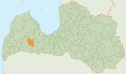
Brocēni Municipality (Latvian: Brocēnu novads) was a municipality in Courland, Latvia. As of 2020, the population was 5,633.[3]
History
The municipality was formed in 2001 by merging Blīdene parish, Remte parish and Brocēni town with its countryside territory, the administrative centre being Brocēni. In 2009 the municipality absorbed Gaiķi parish as well. In 2010 Ciecere parish was created from the countryside territory of Brocēni town. On 1 July 2021, the municipality was merged with Saldus Municipality. The name of the new municipality is Saldus Municipality.
Geography
The district is located to the east of the city Saldus. Limestone is mined at Lake Cieceres and at Brocēni. The railway line from Riga to Liepāja runs through the district in a west-east direction.
See also
References
- ^ Error: Unable to display the reference properly. See the documentation for details.
- ^ Error: Unable to display the reference properly. See the documentation for details.
- ^ "ISG020. Population number and its change by statistical region, city, town, 21 development centres and county". Central Statistical Bureau of Latvia. 2020-01-01. Retrieved 2021-02-12.
External links
 Media related to Brocēni Municipality at Wikimedia Commons
- v
- t
- e
Former first-level administrative divisions of Latvia (2009–2021)

- Aglona
- Aizkraukle
- Aizpute
- Aknīste
- Aloja
- Alsunga
- Alūksne
- Amata
- Ape
- Auce
- Ādaži
- Babīte
- Baldone
- Baltinava
- Balvi
- Bauska
- Beverīna
- Brocēni
- Burtnieki
- Carnikava
- Cesvaine
- Cēsis
- Cibla
- Dagda
- Daugavpils
- Dobele
- Dundaga
- Durbe
- Engure
- Ērgļi
- Garkalne
- Grobiņa
- Gulbene
- Iecava
- Ikšķile
- Ilūkste
- Inčukalns
- Jaunjelgava
- Jaunpiebalga
- Jaunpils
- Jelgava
- Jēkabpils
- Kandava
- Kārsava
- Kocēni
- Koknese
- Krāslava
- Krimulda
- Krustpils
- Kuldīga
- Ķegums
- Ķekava
- Lielvārde
- Limbaži
- Līgatne
- Līvāni
- Lubāna
- Ludza
- Madona
- Mazsalaca
- Mālpils
- Mārupe
- Mērsrags
- Naukšēni
- Nereta
- Nīca
- Ogre
- Olaine
- Ozolnieki
- Pārgauja
- Pāvilosta
- Pļaviņas
- Preiļi
- Priekule
- Priekuļi
- Rauna
- Rēzekne
- Riebiņi
- Roja
- Ropaži
- Rucava
- Rugāji
- Rundāle
- Rūjiena
- Salacgrīva
- Sala
- Salaspils
- Saldus
- Saulkrasti
- Sēja
- Sigulda
- Skrīveri
- Skrunda
- Smiltene
- Stopiņi
- Strenči
- Talsi
- Tērvete
- Tukums
- Vaiņode
- Valka
- Varakļāni
- Vārkava
- Vecpiebalga
- Vecumnieki
- Ventspils
- Viesīte
- Viļaka
- Viļāni
- Zilupe
56°44′00″N 22°39′00″E / 56.7333°N 22.6500°E / 56.7333; 22.6500
Authority control databases | |
|---|---|
| National |
|
| Geographic |
|
 | This Courland location article is a stub. You can help Wikipedia by expanding it. |
- v
- t
- e


