Caballos Formation
Geological formation in Colombia
| Caballos Formation | |
|---|---|
| Stratigraphic range: Aptian-Albian ~120–100 Ma PreꞒ Ꞓ O S D C P T J K Pg N | |
| Type | Geological formation |
| Underlies | Hondita Formation |
| Overlies | Yaví & Saldaña Formations |
| Thickness | up to 411 m (1,348 ft) |
| Lithology | |
| Primary | Sandstone, shale, siltstone |
| Other | Limestone, coal |
| Location | |
| Coordinates | 3°49′18.9″N 75°21′22.4″W / 3.821917°N 75.356222°W / 3.821917; -75.356222 |
| Region | Caquetá, Huila, Putumayo & Tolima Departments |
| Country |  Colombia Colombia |
| Extent | VSM & Caguán-Putumayo Basin Central & Eastern Ranges, Andes |
| Type section | |
| Named for | Cerro Caballos |
| Named by | Corrigan |
| Location | Olaya Herrera |
| Year defined | 1967 |
| Coordinates | 3°49′18.9″N 75°21′22.4″W / 3.821917°N 75.356222°W / 3.821917; -75.356222 |
| Approximate paleocoordinates | 2°54′S 47°24′W / 2.9°S 47.4°W / -2.9; -47.4 |
| Region | Tolima |
| Country | Colombia |
| Thickness at type section | 411 m (1,348 ft) |
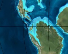 Paleogeography of Northern South America 105 Ma, by Ron Blakey | |
The Caballos Formation (Spanish: Formación Caballos, KI) is a geological formation of the Upper Magdalena Valley (VSM), Caguán-Putumayo Basin, Central and Eastern Ranges of the Colombian Andes. The sandstone and shale formation dates to the Middle Cretaceous period; Aptian to Albian epochs and has a maximum thickness of 411 metres (1,348 ft).
Etymology
The formation was defined and named in 1967 by Corrigan after Cerro Caballos, to the west of Olaya Herrera, Tolima.[1]
Description
Lithologies
The Caballos Formation has a maximum thickness of 411 metres (1,348 ft) in the Quebrada Bambucá and is characterized by a lower sequence of fine to coarse sandstones, of lithic arenite, quartz arenite and feldspar arenite composition, a middle section of fossiliferous black shales and siltstones, intercalated by micritic limestones and coals and very fine sandstones. The upper part of the formation contains conglomerates and glauconitic sandstones.[1]
Stratigraphy and depositional environment
The Caballos Formation in some parts concordantly overlies the Yaví Formation and in other parts rests unconformably on the Saldaña Formation and Ibagué Batholith.[2] The formation is overlain by the Hondita Formation. The age has been estimated to be Aptian to Albian. Stratigraphically, the formation is time equivalent with the Une, Aguardiente, Simijaca, El Peñón, Capotes, Tablazo, Tibú-Mercedes and Pacho Formations.[3] The formation has been deposited in a fluvial to estuarine and shallow marine environment.[4]
The Caballos Formation is a source, reservoir and seal rock in the Upper Magdalena Valley,[5][6] and a source and reservoir rock in the Caguán-Putumayo Basin.[7][8] The Orito and Moqueta Fields of the latter basin produce from Caballos reservoirs.
Fossil content
The formation has provided fossils of Heminautilus etheringtoni,[9] Araucarites sp., Brachyphyllum sp., Cladophlebis sp., and Weichselia sp.,[10] as well as many types of pollen.[11]
Outcrops


class=notpageimage|
Type locality of the Caballos Formation in TolimaThe Caballos Formation is apart from its type locality, found in Huila, Tolima and Putumayo Departments.
Regional correlations
| Ma | Age | Paleomap | Regional events | Catatumbo | Cordillera | proximal Llanos | distal Llanos | Putumayo | VSM | Environments | Maximum thickness | Petroleum geology | Notes |
|---|---|---|---|---|---|---|---|---|---|---|---|---|---|
| 0.01 | Holocene |  | Holocene volcanism Seismic activity | alluvium | Overburden | ||||||||
| 1 | Pleistocene |  | Pleistocene volcanism Andean orogeny 3 Glaciations | Guayabo | Soatá Sabana | Necesidad | Guayabo | Gigante Neiva | Alluvial to fluvial (Guayabo) | 550 m (1,800 ft) (Guayabo) | [12][13][14][15] | ||
| 2.6 | Pliocene |  | Pliocene volcanism Andean orogeny 3 GABI | Subachoque | |||||||||
| 5.3 | Messinian | Andean orogeny 3 Foreland | Marichuela | Caimán | Honda | [14][16] | |||||||
| 13.5 | Langhian | Regional flooding | León | hiatus | Caja | León | Lacustrine (León) | 400 m (1,300 ft) (León) | Seal | [15][17] | |||
| 16.2 | Burdigalian | Miocene inundations Andean orogeny 2 | C1 | Carbonera C1 | Ospina | Proximal fluvio-deltaic (C1) | 850 m (2,790 ft) (Carbonera) | Reservoir | [16][15] | ||||
| 17.3 | C2 | Carbonera C2 | Distal lacustrine-deltaic (C2) | Seal | |||||||||
| 19 | C3 | Carbonera C3 | Proximal fluvio-deltaic (C3) | Reservoir | |||||||||
| 21 | Early Miocene | Pebas wetlands | C4 | Carbonera C4 | Barzalosa | Distal fluvio-deltaic (C4) | Seal | ||||||
| 23 | Late Oligocene |  | Andean orogeny 1 Foredeep | C5 | Carbonera C5 | Orito | Proximal fluvio-deltaic (C5) | Reservoir | [13][16] | ||||
| 25 | C6 | Carbonera C6 | Distal fluvio-lacustrine (C6) | Seal | |||||||||
| 28 | Early Oligocene | C7 | C7 | Pepino | Gualanday | Proximal deltaic-marine (C7) | Reservoir | [13][16][18] | |||||
| 32 | Oligo-Eocene | C8 | Usme | C8 | onlap | Marine-deltaic (C8) | Seal Source | [18] | |||||
| 35 | Late Eocene |  | Mirador | Mirador | Coastal (Mirador) | 240 m (790 ft) (Mirador) | Reservoir | [15][19] | |||||
| 40 | Middle Eocene | Regadera | hiatus | ||||||||||
| 45 | |||||||||||||
| 50 | Early Eocene |  | Socha | Los Cuervos | Deltaic (Los Cuervos) | 260 m (850 ft) (Los Cuervos) | Seal Source | [15][19] | |||||
| 55 | Late Paleocene | PETM 2000 ppm CO2 | Los Cuervos | Bogotá | Gualanday | ||||||||
| 60 | Early Paleocene | SALMA | Barco | Guaduas | Barco | Rumiyaco | Fluvial (Barco) | 225 m (738 ft) (Barco) | Reservoir | [12][13][16][15][20] | |||
| 65 | Maastrichtian |  | KT extinction | Catatumbo | Guadalupe | Monserrate | Deltaic-fluvial (Guadalupe) | 750 m (2,460 ft) (Guadalupe) | Reservoir | [12][15] | |||
| 72 | Campanian | End of rifting | Colón-Mito Juan | [15][21] | |||||||||
| 83 | Santonian | Villeta/Güagüaquí | |||||||||||
| 86 | Coniacian | ||||||||||||
| 89 | Turonian | Cenomanian-Turonian anoxic event | La Luna | Chipaque | Gachetá | hiatus | Restricted marine (all) | 500 m (1,600 ft) (Gachetá) | Source | [12][15][22] | |||
| 93 | Cenomanian |  | Rift 2 | ||||||||||
| 100 | Albian | Une | Une | Caballos | Deltaic (Une) | 500 m (1,600 ft) (Une) | Reservoir | [16][22] | |||||
| 113 | Aptian |  | Capacho | Fómeque | Motema | Yaví | Open marine (Fómeque) | 800 m (2,600 ft) (Fómeque) | Source (Fóm) | [13][15][23] | |||
| 125 | Barremian | High biodiversity | Aguardiente | Paja | Shallow to open marine (Paja) | 940 m (3,080 ft) (Paja) | Reservoir | [12] | |||||
| 129 | Hauterivian |  | Rift 1 | Tibú- Mercedes | Las Juntas | hiatus | Deltaic (Las Juntas) | 910 m (2,990 ft) (Las Juntas) | Reservoir (LJun) | [12] | |||
| 133 | Valanginian | Río Negro | Cáqueza Macanal Rosablanca | Restricted marine (Macanal) | 2,935 m (9,629 ft) (Macanal) | Source (Mac) | [13][24] | ||||||
| 140 | Berriasian | Girón | |||||||||||
| 145 | Tithonian | Break-up of Pangea | Jordán | Arcabuco | Buenavista Batá | Saldaña | Alluvial, fluvial (Buenavista) | 110 m (360 ft) (Buenavista) | "Jurassic" | [16][25] | |||
| 150 | Early-Mid Jurassic |  | Passive margin 2 | La Quinta | Montebel Noreán | hiatus | Coastal tuff (La Quinta) | 100 m (330 ft) (La Quinta) | [26] | ||||
| 201 | Late Triassic |  | Mucuchachi | Payandé | [16] | ||||||||
| 235 | Early Triassic |  | Pangea | hiatus | "Paleozoic" | ||||||||
| 250 | Permian |  | |||||||||||
| 300 | Late Carboniferous |  | Famatinian orogeny | Cerro Neiva () | [27] | ||||||||
| 340 | Early Carboniferous | Fossil fish Romer's gap | Cuche (355-385) | Farallones () | Deltaic, estuarine (Cuche) | 900 m (3,000 ft) (Cuche) | |||||||
| 360 | Late Devonian |  | Passive margin 1 | Río Cachirí (360-419) | Ambicá () | Alluvial-fluvial-reef (Farallones) | 2,400 m (7,900 ft) (Farallones) | [24][28][29][30][31] | |||||
| 390 | Early Devonian |  | High biodiversity | Floresta (387-400) El Tíbet | Shallow marine (Floresta) | 600 m (2,000 ft) (Floresta) | |||||||
| 410 | Late Silurian | Silurian mystery | |||||||||||
| 425 | Early Silurian | hiatus | |||||||||||
| 440 | Late Ordovician |  | Rich fauna in Bolivia | San Pedro (450-490) | Duda () | ||||||||
| 470 | Early Ordovician | First fossils | Busbanzá (>470±22) Chuscales Otengá | Guape () | Río Nevado () | Hígado () | [32][33][34] | ||||||
| 488 | Late Cambrian |  | Regional intrusions | Chicamocha (490-515) | Quetame () | Ariarí () | SJ del Guaviare (490-590) | San Isidro () | [35][36] | ||||
| 515 | Early Cambrian | Cambrian explosion | [34][37] | ||||||||||
| 542 | Ediacaran |  | Break-up of Rodinia | pre-Quetame | post-Parguaza | El Barro () | Yellow: allochthonous basement (Chibcha Terrane) Green: autochthonous basement (Río Negro-Juruena Province) | Basement | [38][39] | ||||
| 600 | Neoproterozoic | Cariri Velhos orogeny | Bucaramanga (600-1400) | pre-Guaviare | [35] | ||||||||
| 800 |  | Snowball Earth | [40] | ||||||||||
| 1000 | Mesoproterozoic |  | Sunsás orogeny | Ariarí (1000) | La Urraca (1030-1100) | [41][42][43][44] | |||||||
| 1300 | Rondônia-Juruá orogeny | pre-Ariarí | Parguaza (1300-1400) | Garzón (1180-1550) | [45] | ||||||||
| 1400 |  | pre-Bucaramanga | [46] | ||||||||||
| 1600 | Paleoproterozoic | Maimachi (1500-1700) | pre-Garzón | [47] | |||||||||
| 1800 |  | Tapajós orogeny | Mitú (1800) | [45][47] | |||||||||
| 1950 | Transamazonic orogeny | pre-Mitú | [45] | ||||||||||
| 2200 | Columbia | ||||||||||||
| 2530 | Archean |  | Carajas-Imataca orogeny | [45] | |||||||||
| 3100 | Kenorland | ||||||||||||
| Sources | |||||||||||||
- Legend
- group
- important formation
- fossiliferous formation
- minor formation
- (age in Ma)
- proximal Llanos (Medina)[note 1]
- distal Llanos (Saltarin 1A well)[note 2]
See also
- List of fossiliferous stratigraphic units in Colombia
- Geology of the Eastern Hills
- Geology of the Altiplano Cundiboyacense
Notes
References
- ^ a b Velandia et al., 2001, p.53
- ^ Velandia et al., 2001, p.34
- ^ Velandia et al., 2001, p.54
- ^ Villamil, 2012, p.166
- ^ ANH, 2007, p.84
- ^ García González et al., 2009, p.83
- ^ ANH, 2007, p.57
- ^ García González et al., 2009, p.16
- ^ Badouin et al., 2016, p.87
- ^ Monje et al., 2016, p.38
- ^ Los Mangos at Fossilworks.org
- ^ a b c d e f García González et al., 2009, p.27
- ^ a b c d e f García González et al., 2009, p.50
- ^ a b García González et al., 2009, p.85
- ^ a b c d e f g h i j Barrero et al., 2007, p.60
- ^ a b c d e f g h Barrero et al., 2007, p.58
- ^ Plancha 111, 2001, p.29
- ^ a b Plancha 177, 2015, p.39
- ^ a b Plancha 111, 2001, p.26
- ^ Plancha 111, 2001, p.24
- ^ Plancha 111, 2001, p.23
- ^ a b Pulido & Gómez, 2001, p.32
- ^ Pulido & Gómez, 2001, p.30
- ^ a b Pulido & Gómez, 2001, pp.21-26
- ^ Pulido & Gómez, 2001, p.28
- ^ Correa Martínez et al., 2019, p.49
- ^ Plancha 303, 2002, p.27
- ^ Terraza et al., 2008, p.22
- ^ Plancha 229, 2015, pp.46-55
- ^ Plancha 303, 2002, p.26
- ^ Moreno Sánchez et al., 2009, p.53
- ^ Mantilla Figueroa et al., 2015, p.43
- ^ Manosalva Sánchez et al., 2017, p.84
- ^ a b Plancha 303, 2002, p.24
- ^ a b Mantilla Figueroa et al., 2015, p.42
- ^ Arango Mejía et al., 2012, p.25
- ^ Plancha 350, 2011, p.49
- ^ Pulido & Gómez, 2001, pp.17-21
- ^ Plancha 111, 2001, p.13
- ^ Plancha 303, 2002, p.23
- ^ Plancha 348, 2015, p.38
- ^ Planchas 367-414, 2003, p.35
- ^ Toro Toro et al., 2014, p.22
- ^ Plancha 303, 2002, p.21
- ^ a b c d Bonilla et al., 2016, p.19
- ^ Gómez Tapias et al., 2015, p.209
- ^ a b Bonilla et al., 2016, p.22
- ^ a b Duarte et al., 2019
- ^ García González et al., 2009
- ^ Pulido & Gómez, 2001
- ^ García González et al., 2009, p.60
Bibliography
- Badouin, Cyril; Gérard Delanoy; Josep Antón Moreno Bedmar; Antoine Pictet; Jean Vermeulen; Gabriel Conte; Roland Gonnet; Patrick Boselli, and Marc Bonelli. 2016. Revision of the Early Cretaceous genera Heminautilus SPATH, 1927, and Josanautilus MARTÍNEZ & GRAUGES, 2006 (Nautilida, Cenoceratidae). Carnets Geologicás 16. 61–212. Accessed 2017-01-20.
- Barrero, Dario; Andrés Pardo; Carlos A. Vargas, and Juan F. Martínez. 2007. Colombian Sedimentary Basins: Nomenclature, Boundaries and Petroleum Geology, a New Proposal, 1–92. ANH.
- García González, Mario; Ricardo Mier Umaña; Luis Enrique Cruz Guevara, and Mauricio Vásquez. 2009. Informe Ejecutivo - evaluación del potencial hidrocarburífero de las cuencas colombianas, 1–219. Universidad Industrial de Santander.
- Monje Durán, Camila; Camila Martínez; Ignacio Escapa, and Santiago Madriñán. 2016. Nuevos registros de helechos y coníferas del Cretácico Inferior en la cuenca del Valle Superior del Magdalena, Colombia. Boletín de Geología, Universidad Industrial de Santander 38. 29–42. Accessed 2017-03-31.
- Núñez Tello, Alberto. 2003. Cartografía geológica de las zonas Andina Sur y Garzón-Quetame (Colombia) - Memoria explicativa de las planchas 411 La Cruz, 412 San Juan de Villalobos, 430 Mocoa, 431 Piamonte, 448 Monopamba, 449 Orito y 465 Churuyaco, 1–298. INGEOMINAS.
- Velandia P., Francisco; Alberto Núñez T., and Germán Marquínez. 2001. Mapa Geológico del Departamento del Huila - 1:300,000 - Memoria explicativa, 1–152. INGEOMINAS.
- Villamil, Tomas. 2012. Chronology Relative Sea Level History and a New Sequence Stratigraphic Model for Basinal Cretaceous Facies of Colombia, 161–216. Society for Sedimentary Geology (SEPM).
Maps
- Marquínez, Germán, and Francisco Velandia. 2001. Mapa Geológico del Huila 1:300,000, 1. INGEOMINAS. Accessed 2017-09-21.
- Fuquen, Jaime A., and Alberto Nuñez. 2003. Mapa Geológico del Putumayo 1:400,000, 1. INGEOMINAS. Accessed 2017-09-21.
- Acosta, Jorge E.; Rafael Guatame; Oscar Torres, and Frank Solano. 1999. Plancha 245 - Girardot - 1:100,000, 1. INGEOMINAS. Accessed 2017-06-06.
- Nuñez, Alberto; Dario Mosquera, and Carlos J. Vesga. 2009. Plancha 263 - Ortega - 1:100,000, 1. INGEOMINAS. Accessed 2017-06-06.
- Calcedo, Juan Carlos, and Roberto Terraza. 2000. Plancha 264 - Espinal - 1:100,000, 1. INGEOMINAS. Accessed 2017-06-06.
- Acosta, Jorge; Juan Carlos Calcedo, and Carlos Ulloa. 1999. Plancha 265 - Icononzo - 1:100,000, 1. INGEOMINAS. Accessed 2017-06-06.
- Carvajal, Cesar; Jaime Fuquen, and Luis Gómez. 1993. Plancha 282 - Chaparral - 1:100,000, 1. INGEOMINAS. Accessed 2017-06-06.
- Cossio, Ubaldo; Gabriel Rodríguez, and Miguel Rodríguez. 1995. Plancha 283 - Purificación - 1:100,000, 1. INGEOMINAS. Accessed 2017-06-06.
- Fuquen, Jaime; Gabriel Rodríguez; Ubaldo Cossio, and Alberto Núñez. 1993. Plancha 302 - Aipe - 1:100,000, 1. INGEOMINAS. Accessed 2017-06-06.
- Acosta, Jorge; Pablo Caro; Jaime Fuquen, and José Osorno. 2002. Plancha 303 - Colombia - 1:100,000, 1. INGEOMINAS.
- Gómez, Jorge; Carlos Morales; Germán Marquínez, and Francisco Velandia. 1999. Plancha 322 - Santa María - 1:100,000, 1. INGEOMINAS. Accessed 2017-06-06.
- Ferreira, Paulina; Alberto Núñez, and Miguel Rodríguez. 1998. Plancha 323 - Neiva - 1:100,000, 1. INGEOMINAS. Accessed 2017-06-06.
- Marquínez, Germán; C. Morales, and Alberto Núñez. 1999. Plancha 344 - Tesalia - 1:100,000, 1. INGEOMINAS. Accessed 2017-06-06.
- Velandia, F.; C.J. Morales; J.C. Caicedo, and Alberto Núñez. 1999. Plancha 345 - Campoalegre - 1:100,000, 1. INGEOMINAS. Accessed 2017-06-06.
- Marquínez, Germán; Yohana Rodríguez; Roberto Terraza, and Mario Martínez. 2003. Plancha 365 - Coconuco - 1:100,000, 1. INGEOMINAS. Accessed 2017-06-06.
- Rodríguez, Gabriel; Paulina Ferreira; Francisco Velandia, and Alberto Núñez. 1998. Plancha 366 - Garzón - 1:100,000, 1. INGEOMINAS. Accessed 2017-06-06.
- Rodríguez, Gabriel; Gilberto Zapata, and M. Velázquez. 2003. Plancha 389 - Timaná - 1:100,000, 1. INGEOMINAS. Accessed 2017-06-06.
- Núñez, Alberto, and Jorge Gómez. 2002. Plancha 411 - La Cruz - 1:100,000, 1. INGEOMINAS. Accessed 2017-06-06.
- Núñez, Alberto, and Jorge Gómez. 2002. Plancha 412 - San Juan de Villalobos - 1:100,000, 1. INGEOMINAS. Accessed 2017-06-06.
- Núñez, Alberto, and Jorge Gómez. 2002. Plancha 430 - Mocoa - 1:100,000, 1. INGEOMINAS. Accessed 2017-06-06.
- Núñez, Alberto, and Jorge Gómez. 2002. Plancha 431 - Piamonte - 1:100,000, 1. INGEOMINAS. Accessed 2017-06-06.
- Núñez, Alberto, and Jorge Gómez. 2002. Plancha 448 - Monopamba - 1:100,000, 1. INGEOMINAS. Accessed 2017-06-06.
- Núñez, Alberto, and Jorge Gómez. 2002. Plancha 449 - Orito - 1:100,000, 1. INGEOMINAS. Accessed 2017-06-06.
- Núñez, Alberto, and Jorge Gómez. 2002. Plancha 465 - Churiyaco - 1:100,000, 1. INGEOMINAS. Accessed 2017-06-06.


