Chroustov
Municipality in Central Bohemian, Czech Republic
50°17′12″N 15°20′50″E / 50.28667°N 15.34722°E / 50.28667; 15.34722 Czech Republic
 (2023-01-01)[1]
289 02
Chroustov is a municipality and village in Nymburk District in the Central Bohemian Region of the Czech Republic. It has about 200 inhabitants.
Chroustov is located about 25 kilometres (16 mi) northeast of Nymburk and 69 kilometres (43 mi) east of Prague.
Administrative parts
The village of Dvořiště is an administrative part of Chroustov.
Demographics
| Year | Pop. | ±% |
|---|---|---|
| 1869 | 648 | — |
| 1880 | 806 | +24.4% |
| 1890 | 797 | −1.1% |
| 1900 | 711 | −10.8% |
| 1910 | 729 | +2.5% |
| 1921 | 635 | −12.9% |
| 1930 | 581 | −8.5% |
| 1950 | 441 | −24.1% |
| 1961 | 385 | −12.7% |
| 1970 | 282 | −26.8% |
| 1980 | 241 | −14.5% |
| 1991 | 222 | −7.9% |
| 2001 | 201 | −9.5% |
| 2011 | 215 | +7.0% |
| 2021 | 200 | −7.0% |
| Source: Censuses[2][3] | ||
Gallery
-
 Návesník pond
 -
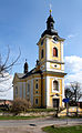 Church of the Assumption of the Virgin Mary
 -
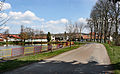
 The village of Dvořiště


References
- ^ "Population of Municipalities – 1 January 2023". Czech Statistical Office. 2023-05-23.
- ^ "Historický lexikon obcí České republiky 1869–2011 – Okres Nymburk" (in Czech). Czech Statistical Office. 2015-12-21. pp. 3–4.
- ^ "Population Census 2021: Population by sex". Public Database. Czech Statistical Office. 2021-03-27.
External links
Wikimedia Commons has media related to Chroustov.
- Official website
- v
- t
- e
Towns, market towns and villages of Nymburk District
- Běrunice
- Bobnice
- Bříství
- Budiměřice
- Chleby
- Choťánky
- Chotěšice
- Chrást
- Chroustov
- Čilec
- Činěves
- Dlouhopolsko
- Dobšice
- Dvory
- Dymokury
- Hořany
- Hořátev
- Hradčany
- Hradištko
- Hrubý Jeseník
- Jíkev
- Jiřice
- Jizbice
- Kamenné Zboží
- Kněžice
- Kněžičky
- Kolaje
- Košík
- Kostelní Lhota
- Kostomlátky
- Kostomlaty nad Labem
- Kounice
- Kouty
- Kovanice
- Krchleby
- Křečkov
- Křinec
- Libice nad Cidlinou
- Loučeň
- Lysá nad Labem
- Mcely
- Městec Králové
- Milčice
- Milovice
- Netřebice
- Nový Dvůr
- Nymburk
- Odřepsy
- Okřínek
- Opočnice
- Opolany
- Oseček
- Oskořínek
- Ostrá
- Pátek
- Písková Lhota
- Písty
- Poděbrady
- Podmoky
- Přerov nad Labem
- Rožďalovice
- Sadská
- Sány
- Seletice
- Semice
- Senice
- Sloveč
- Sokoleč
- Stará Lysá
- Starý Vestec
- Straky
- Stratov
- Třebestovice
- Úmyslovice
- Velenice
- Velenka
- Vestec
- Vlkov pod Oškobrhem
- Vrbice
- Vrbová Lhota
- Všechlapy
- Vykáň
- Záhornice
- Zbožíčko
- Žitovlice
- Zvěřínek
| Authority control databases: National |
|
|---|
 | This Central Bohemian Region location article is a stub. You can help Wikipedia by expanding it. |
- v
- t
- e


