Como, Colorado
Unincorporated community in Park County, Colorado, United States
Unincorporated community in State of Colorado, United States
39°18′58″N 105°53′34″W / 39.31611°N 105.89278°W / 39.31611; -105.89278 United States
 State of Colorado
 (2010)
80432
Como is an unincorporated community in Park County in the Rocky Mountains of central Colorado, United States. According to the 2010 census, the population of zip code 80432 is 439, including surrounding subdivisions in a 15 mile radius. Metropolitan Como proper usually has a population of 12 to 15 residents, within the Como plat.[4]
History

It is believed the town was named by miners from Como, Italy, who worked the coal fields of the area. In 1879, the town became the location of a depot of the Denver, South Park and Pacific Railroad, which was extended over Kenosha Pass to reach the silver mining areas during the Colorado Silver Boom. Later, the town served as a division point for trains going northward over Boreas Pass and southward toward Garos and over Trout Creek Pass at the western end of South Park.
Current status
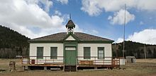
The town has many historic weathered structures, including the roundhouse, hotel, and depot. It has the air of a ghost town that is still nevertheless populated. Como has a small commercial district consisting of a post office, gallery and hotel. The roundhouse and depot have been renovated by the Denver, South Park & Pacific Historical Society with plans to make them into an area tourist attraction.[5]

Geography
Como is located at the northern end of South Park, Como is an historic railroad settlement. It sits approximately one-half mile (1 km) west of U.S. Route 285 and some nine miles (15 km) northeast of the county seat of Fairplay. Como is accessible by a paved County Road 33, which becomes gravel inside the town. Boreas Pass Road runs northwest over Boreas Pass to Breckenridge. The mountains northwest of Como form a dramatic background to the site of the town on the flank of Little Baldy Mountain.
See also
 Colorado portal

References
- ^ "US Board on Geographic Names". United States Geological Survey. October 25, 2007. Retrieved January 31, 2008.
- ^ a b U.S. Geological Survey Geographic Names Information System: Como, Colorado
- ^ "ZIP Code Lookup". United States Postal Service. December 22, 2006. Archived from the original (JavaScript/HTML) on September 3, 2007. Retrieved December 22, 2006.
- ^ "2010 Census Population for ZIP Code 80432". zip-coedes.com. Retrieved February 4, 2014.
- ^ Laura King Van Dusen, "Como High School: An Unplanned Time Capsule of Earlier Days, Artifacts Uncovered from Como's Heyday," Historic Tales from Park County: Parked in the Past (Charleston, South Carolina: The History Press, 2013), ISBN 978-1-62619-161-7, pp. 163-169.
External links
![]() Media related to Como, Colorado at Wikimedia Commons
Media related to Como, Colorado at Wikimedia Commons
- v
- t
- e
Municipalities and communities of Park County, Colorado, United States
County seat: Fairplay

communities
- Alma Junction
- Antero Junction
- Buckskin Joe
- Garo
- Tarryall
- Trump
- Colorado portal
- United States portal
Authority control databases | |
|---|---|
| International |
|
| National |
|
| Other |
|


