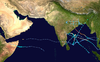
Extremely Severe Cyclonic Storm Phailin (/ˈpaɪlɪn/; Thai: ไพลิน, romanized: Phịlin, lit. 'sapphire')[1] was one of the most intense tropical cyclones to make landfall in India since the 1999 Odisha cyclone.[2] The system was first noted as a tropical depression on October 4, 2013, within the Gulf of Thailand, to the west of Phnom Penh in Cambodia. Over the next few days, it moved westwards within an area of low to moderate vertical wind shear, before as it passed over the Malay Peninsula, it moved out of the Western Pacific Basin on October 6. It emerged into the Andaman Sea during the next day and moved west-northwest into an improving environment for further development before the system was named Phailin on October 9, after it had developed into a cyclonic storm and passed over the Andaman and Nicobar Islands into the Bay of Bengal.
During the next day, Phailin intensified rapidly and became a very severe cyclonic storm on October 10, equivalent to a Category 1 hurricane on the Saffir–Simpson hurricane wind scale (SSHWS). On October 11, the system became equivalent to a Category 5 hurricane on the SSHWS, before it started to weaken during the next day, as it approached the Indian state of Odisha. It made landfall later that day, near Gopalpur in Odisha coast, at around 22:30 IST (17:00 UTC) on October 12. Phailin subsequently weakened over land (becoming a Category 1 tropical cyclone) as a result of frictional forces, before it was last noted on October 14, as it degenerated into a well-marked area of low pressure.
Officials from Odisha's state government said that around 12 million people may be affected. The cyclone prompted India's biggest evacuation in 23 years with more than 550,000 people moved up from the coastline in Odisha and Andhra Pradesh to safer places.[3] Total losses were estimated at ₹260 billion (US$4.26 billion) from the storm.
On October 4, the Japan Meteorological Agency started to monitor a tropical depression that had developed in the Gulf of Thailand, about 400 km (250 mi) west of Ho Chi Minh City in Vietnam.[4][5] Over the next couple of days, the system moved westward within an area of low to moderate vertical wind shear, before it passed over the Malay Peninsula and moved out of the Western Pacific Basin on October 6.[6][7][8] The system then subsequently emerged into the Andaman Sea during the next day, before the India Meteorological Department (IMD) started to monitor the system as Depression BOB 04, early on October 8.[9][10][11] During that day, the system moved towards the west-northwest into an environment favorable for more development, before the IMD reported that the system had become a deep depression early on October 9, as it intensified and consolidated further.[11][12] The United States Joint Typhoon Warning Center (JTWC) subsequently initiated advisories on the depression and designated it as Tropical Cyclone 02B, before the system slightly weakened, as it passed near Mayabunder in the Andaman Islands and moved into the Bay of Bengal.[13][14][15] After moving into the Bay of Bengal, the system quickly reorganized as it moved along the southern edge of a subtropical ridge of high pressure. The IMD reported that the system had intensified into a cyclonic storm and named it Phailin.[15][16]
Satellite loop of Phailin making landfall on the coast of Odisha, on October 12
After it was named, Phailin rapidly intensified further, and became the equivalent of a Category 1 hurricane on the Saffir–Simpson hurricane wind scale (SSHWS) early on October 10. After bands of atmospheric convection had wrapped into the systems low level circulation center and formed an eye feature.[17][18] Later that day, the IMD reported that the system had become a very severe cyclonic storm, before the JTWC reported that Phailin had become equivalent to a Category 4 hurricane on the SSHWS, after it had rapidly intensified throughout that day.[19][20] Early the next day the system underwent an eyewall replacement cycle and formed a new eyewall which subsequently consolidated.[21] After the new eyewall had consolidated the system slightly intensified further, with the JTWC reporting that the system had reached its peak intensity, with 1-minute sustained wind speeds of 260 km/h (160 mph) which made it equivalent to a Category 5 hurricane on the SSHWS.[22][23] Early on October 12, the system started to weaken as it underwent a second eyewall replacement cycle, before Phailin's eye started to rapidly deteriorate as it moved towards the Indian coast.[24][25] The system subsequently made landfall later that day near Gopalpur in Odisha, at around 22:30 IST (17:00 UTC), near peak intensity.[11] After the system made landfall, the JTWC issued their final advisory on Phailin; on the next day, the IMD reported that the system had weakened into a cyclonic storm. On October 14, Phailin weakened into a well-marked low-pressure area, and the IMD issued their final advisory on the storm.[26][27]
In all, 46 people were killed in India, and the economic losses reached ₹260 billion (US$4.26 billion).[28]
Andaman and Nicobar Islands
On October 8, the IMD warned the Andaman and Nicobar Islands that squally to gale-force wind speeds would be recorded over the islands and surrounding sea areas during the next two days.[10] They also warned that heavy to very heavy rainfall would occur over the islands while some damage to thatched huts, power and communication lines was expected.[10] These warnings were continued until October 11, when the IMD noted that no further adverse weather, would occur over the Andaman and Nicobar Islands.[29] Within the islands the Directorate of Health Services opened a Medical Camp in Rangat, while the Deputy Commissioner, Police and Fire Services all ensured there were no casualties.[30] Between October 8–10, rainfall totals of 734 mm (28.9 in) and 434 mm (17.1 in) were recorded in Mayabunder and on the Long Island.[30][31][32][33]
Andhra Pradesh
The Andhra Pradesh government and the Chief Minister met representatives of the Army and Navy seeking their assistance if required.[34] Utility workers striking against the division of Andhra Pradesh called off their strike partly in view of the cyclone threat to the coastal districts.[35] The state government ordered the evacuation of 64,000 people living in low-lying areas.[36]
The coastal districts of the state escaped the force of the cyclone. However, Srikakulam district experienced heavy rains and gale-force winds which uprooted tall trees and electric poles, shutting down power to areas.[37] Throughout the state, one person was killed and damage amounted to ₹500 million (US$8.2 million).[38] A total of 134,426 people were evacuated in the wake of the storm.[39]
Odisha
Twenty-four-hour rainfall forecast for Phailin.
Government of Odisha and it agency OSDMA evacuated close to a million people to cyclone shelters.[40] Distant storm warning signal was raised to two at the ports of Paradip and Gopalpur of the state.[41] The Chief Minister of Odisha wrote to the Union Defence Minister seeking support from defence personnel, particularly the Air Force and Navy, for rescue and relief operations.[42] The Odisha government had made arrangements for over 1,000,560 food packets for relief.[43] Indian Air Force helicopters were kept on standby in West Bengal to move in for help at short notice. A total of 1,154,725 people were evacuated in the wake of the storm and the following floods in the state.[39]
Heavy rainfall resulted in the death of a woman in Bhubaneswar after a tall tree fell on her.[44] Gusty winds resulted in downing of trees and powerlines.[45] It was also reported that due to high winds, seven other people were killed in Odisha.[46] In a period of 24 hours ending on 13 October, Banki and Balimundali in Odisha received heavy rainfall of 381 mm and 305 mm respectively.[47]
As the storm moved inland, wind speeds picked up from 100 km/h (62 mph) to 200 km/h (120 mph) within 30 minutes. Brahmapur, the closest city to the point of landfall suffered devastation triggered by gale winds, with fallen trees, uprooted electric poles and broken walls in various places of the city. However, there were no reports of damage to property or life according to the city police.[37] As of 18 October, 44 people have been reported dead from Odisha.[48]
The high winds and gushing sea that the cyclone brought to Chilika Lake, India's largest coastal lagoon and home to a large number of endangered animal and plant species, had hit the eco-system that may take years to recover. Mangroves had been uprooted for kilometers. Sea water has left vast stretches of land unsuitable for trees or wild plants. Though the cyclone spared Chilika's most famous residents — the dolphins, there are a few concerns.[49]
Losses across Odisha amounted to ₹42.42 billion (US$696 million).[50] Phailin damaged crops over 500,000 hectares of agricultural land throughout the state.[51]
Jharkhand
During October 13, heavy rain from the outer bands of Phailin lashed Jharkhand. A rainfall total of 74.6 mm (2.94 in) was recorded at Ranchi, while Jamshedpur recorded 52.4 mm (2.06 in), and Bokaro recorded 58.4 mm (2.30 in).[52]
Barring an early morning lightning strike at Simdradhao village in Giridih district in which a person was killed, according to police, there were no reports of rain-related casualty anywhere in the state. The Disaster Management Department and the district administrations were monitoring the situation.[52]
At least 400 huts were destroyed following heavy rains accompanied by gales in Pakur district of Jharkhand. Triggered by heavy rains, a couple of pillars of the Irga river bridge were damaged in Giridih District.[53]
Other Indian states
The areas of West Bengal, Chhattisgarh, Bihar and eastern parts of Uttar Pradesh are likely to experience heavy rainfall and strong winds. There is risk of trees falling and disruption of light or electricity poles. However, the effect here will not be as severe as that in Odisha and Andhra Pradesh.
A Merchant Ship MV Bingo was feared to have sunk in rough seas off the coast of West Bengal due to Cyclone Phailin. The crew of 20 were spotted in lifeboats by the Coast Guard and were rescued.[54]
Nepal
October rain caused by Cyclone Phailin in Panchkhal Valley
The eastern region of Nepal experienced heavy rainfall and winds while it was lighter in the central and western part of the country. Rainfall began in the eastern and mid-western region since early morning on 13 October and began in the central regional too in the afternoon . The impact of the cyclone continued until 15 October.[55] Nepalese great festival Dashain was affected by the October rain. It caused flood in Kosi and Gandaki rivers in Nepal.[56]
^Why cyclone Phailin is named so IBNLive.com (CNN–IBN), 2013-10-11.
^"Very Severe Cyclonic Storm, PHAILIN over the Bay of Bengal (08-14 October 2013) : A Report" (PDF). IMD. Archived from the original (PDF) on 6 November 2013. Retrieved October 20, 2013.
^"Cyclone Phailin triggers India's biggest evacuation operation in 23 years". NDTV. 12 October 2013. Retrieved 13 October 2013.
^"JMA WWJP25 Warning and Summary October 4, 2013 18z". Japan Meteorological Agency. October 4, 2013. Archived from the original on May 22, 2024. Retrieved October 10, 2013.
^"What is Cyclonic Storm Phailin?". Bihar Prabha. October 10, 2013. Archived from the original on October 12, 2013. Retrieved October 11, 2013.
^Joint Typhoon Warning Center (October 5, 2013). "Significant Tropical Weather Outlook for the Western and South Pacific Ocean October 5, 2013 13z". United States Navy, United States Air Force. Archived from the original on May 22, 2024. Retrieved October 10, 2013.
^Joint Typhoon Warning Center (October 6, 2013). "Significant Tropical Weather Outlook for the Western and South Pacific Ocean, October 6, 2013 06z". United States Navy, United States Air Force. Archived from the original on May 22, 2024. Retrieved October 10, 2013.
^Joint Typhoon Warning Center (October 6, 2013). "Significant Tropical Weather Outlook for the Indian Ocean October 7, 2013 06z". United States Navy, United States Air force. Archived from the original on May 22, 2024. Retrieved October 10, 2013.
^Joint Typhoon Warning Center (October 7, 2013). "Significant Tropical Weather Outlook for the Indian Ocean October 7, 2013 18z". United States Navy, United States Air Force. Archived from the original on May 22, 2024. Retrieved October 10, 2013.
^ abcRegional Specialized Meteorological Center New Delhi, India (October 8, 2013). "Cyclone Warning For Indian Coast, BOB 04/2013/01" (PDF). India Meteorological Department. Archived from the original (PDF) on October 9, 2013. Retrieved October 10, 2013.
^ abcVery Severe Cyclonic Storm Phalin over the Bay of Bengal (October 08-14 2013) (PDF) (A Report). India Meteorological Department. October 30, 2013. Archived from the original (PDF) on November 6, 2013. Retrieved November 10, 2013.
^Joint Typhoon Warning Center (October 8, 2013). "Tropical Cyclone Formation Alert October 8, 2013 10z". United States Navy, United States Air Force. Archived from the original on May 22, 2024. Retrieved October 10, 2013.
^Joint Typhoon Warning Center (October 8, 2013). "Tropical Cyclone 02B Warning 1". United States Navy, United States Air Force. Archived from the original on May 22, 2024. Retrieved October 10, 2013.
^Regional Specialized Meteorological Center New Delhi, India (October 9, 2013). "Cyclone Warning For Indian Coast, BOB 04/2013/08" (PDF). India Meteorological Department. Archived from the original (PDF) on October 10, 2013. Retrieved October 10, 2013.
^ abJoint Typhoon Warning Center (October 9, 2013). "Tropical Cyclone 02B Warning 3". United States Navy, United States Air Force. Archived from the original on May 22, 2024. Retrieved October 10, 2013.
^Regional Specialized Meteorological Center New Delhi, India (October 9, 2013). "Cyclone Warning For Indian Coast, BOB 04/2013/09" (PDF). India Meteorological Department. Archived from the original (PDF) on October 10, 2013. Retrieved October 10, 2013.
^Joint Typhoon Warning Center (October 10, 2013). "Tropical Cyclone 02B (Phailin) Warning 6". United States Navy, United States Air Force. Archived from the original on May 22, 2024. Retrieved October 11, 2013.
^Joint Typhoon Warning Center (October 10, 2013). "Tropical Cyclone 02B (Phailin) Warning 7". United States Navy, United States Air Force. Archived from the original on October 12, 2013. Retrieved October 11, 2013.
^Regional Specialized Meteorological Center New Delhi, India (October 10, 2013). "Cyclone Warning For Indian Coast, BOB 04/2013/15" (PDF). India Meteorological Department. Archived from the original (PDF) on October 10, 2013. Retrieved October 10, 2013.
^Joint Typhoon Warning Center (October 10, 2013). "Tropical Cyclone 02B (Phailin) Warning 8 October 10, 2013 21z". United States Navy, United States Air Force. Archived from the original on October 12, 2013. Retrieved October 11, 2013.
^Joint Typhoon Warning Center (October 11, 2013). "Tropical Cyclone 02B (Phailin) Warning 10 October 11, 2013 09z". United States Navy, United States Air Force. Archived from the original on May 22, 2024. Retrieved October 11, 2013.
^Joint Typhoon Warning Center (October 11, 2013). "Tropical Cyclone 02B (Phailin) Warning 11 October 11, 2013 15z". United States Navy, United States Air Force. Archived from the original on October 12, 2013. Retrieved October 11, 2013.
^Samenow, Jason (October 11, 2013). "Category 5 Phailin likely a disaster for India, catastrophic storm surge "a certainty"". The Washington Post. Retrieved October 11, 2013.
^Joint Typhoon Warning Center (October 12, 2013). "Tropical Cyclone 02B (Phailin) Warning 14 October 12, 2013 03z". United States Navy, United States Air Force. Archived from the original on October 12, 2013. Retrieved October 12, 2013.
^Joint Typhoon Warning Center (October 12, 2013). "Tropical Cyclone 02B (Phailin) Warning 15 October 12, 2013 15z". United States Navy, United States Air Force. Archived from the original on October 12, 2013. Retrieved October 12, 2013.
^Joint Typhoon Warning Center (October 12, 2013). "Tropical Cyclone 02B (Phailin) Warning 16 October 12, 2013 21z". United States Navy, United States Air Force. Archived from the original on May 22, 2024. Retrieved October 13, 2013.
^Regional Specialized Meteorological Center New Delhi, India (October 13, 2013). "Cyclone Warning For Indian Coast, BOB 04/2013/39" (PDF). India Meteorological Department. Archived from the original (PDF) on October 13, 2013. Retrieved October 13, 2013.
^"Bearing the brunt". The Tribune. May 27, 2019. Retrieved May 30, 2019.
^ abGiles, Denis (October 9, 2013). "Flood Following Heavy Rains and Cyclonic Weather Badly Affects Andamans". Andaman Chronicle. Archived from the original on October 13, 2013. Retrieved October 11, 2013.
^"All India Weather Summary October 8, 2013" (PDF). India Meteorological Department. October 8, 2013. Archived from the original (PDF) on December 8, 2015. Retrieved October 13, 2013.
^"All India Weather Summary October 9, 2013" (PDF). India Meteorological Department. October 9, 2013. Archived from the original (PDF) on October 13, 2013. Retrieved October 13, 2013.
^"All India Weather Summary October 10, 2013" (PDF). India Meteorological Department. October 10, 2013. Archived from the original (PDF) on October 13, 2013. Retrieved October 13, 2013.
^"Live: Odisha, Andhra on alert as cyclone Phailin upgraded to super storm". Firstpost. 11 October 2013. Retrieved 11 October 2013.
^"Relief for Seemandhra after power staff call off strike". The Times of India. 11 October 2013. Retrieved 11 October 2013.
^"Cyclone brings respite from agitation". The Hindu. 2013-10-10. Retrieved 2013-10-14.
^ abPatnaik, Santosh (13 October 2013). "Phailin batters Berhampur". The Hindu. Retrieved 13 October 2013.
^"Phailin claims one life in Andhra Pradesh, inflicts Rs 50cr damages". Times of India. 2013-10-14. Retrieved 2013-10-30.
^ abIndia Meteorological Department. "Very Severe Cyclonic Strom Phailin – Preliminary Report" (PDF). India Meteorological Department. Archived from the original (PDF) on 6 November 2013. Retrieved 2 November 2013.
^"Cyclone Devastation Averted: India Weathers Phailin". World Bank. 2013-10-17. Retrieved 2019-10-22.
^"Odisha, Andhra Pradesh brace for Cyclone Phailin". The Times of India. 10 October 2013. Retrieved 10 October 2013.
^PTI (2013-10-10). "Phailin intensifies into severe cyclonic storm". The Hindu. Retrieved 2013-10-14.
^"Cyclone Phailin Live: Odisha fears a repeat of 1999 super-cyclone". Zee News. 11 October 2013. Retrieved 11 October 2013.
^Karan, Jajati (12 October 2013). "Cyclone Phailin: One dead in Bhubaneswar as heavy rains lash Odisha". IBN Live. Archived from the original on 15 October 2013. Retrieved 27 October 2013.
^"Cyclone Phailin live: 1 dead in Odisha during rain as storm approaches". CNN-IBN. IBN Live. October 12, 2013. Archived from the original on October 12, 2013. Retrieved October 12, 2013.
^"Storm 60 km away from coast, 5 lakh people moved out". ibnlive.in.com. Archived from the original on 12 October 2013. Retrieved 12 October 2013.
^Special Correspondent (2013-10-18). "Odisha's death toll after cyclone, floods climbs to 44". The Hindu. Retrieved 2013-10-30.
^"Hindustan Times – Archive News". Archived from the original on October 17, 2013. Retrieved 12 September 2014.
^"Cyclone Phailin: Odisha seeks Rs 4,242 crore assistance from Centre". Firstpost. 21 October 2012. Retrieved 3 October 2018.
^"Recovery challenge looms in Odisha, Andhra Pradesh". 13 October 2013. Retrieved 13 October 2013.
^ ab"Cyclone Phailin: Heavy rains lash Jharkhand today". IBN News. October 13, 2013. Archived from the original on October 13, 2013. Retrieved October 13, 2013.
^"Phailin effect: 400 hutments destroyed in Jharkhand | India News Analysis, Op-Eds and Podcasts on Niti Central". Archived from the original on 15 September 2014. Retrieved 12 September 2014.
^"Crew of MV Bingo rescued". Sino Ship News. October 15, 2013. Archived from the original on December 3, 2013. Retrieved October 11, 2014.
^"Rainfall across Nepal' Phailin impact to continue tomorrow also". The Himalayan. 2013-10-13. Archived from the original on October 21, 2013. Retrieved 21 October 2013.
^"Heavy rains lash Bihar post Cyclone Phailin, one killed". The Indian Express. Oct 14, 2013. Retrieved 21 October 2013.
External links
Cyclone Phailin at Wikipedia's sister projects
Media from Commons
News from Wikinews
India Meteorological Department
Joint Typhoon Warning Center Archived 2015-08-09 at the Wayback Machine


 Extratropical cyclone, remnant low, tropical disturbance, or monsoon depression