Dolmen of Menga
Megalithic burial mound in Andalusia, Spain
37°01′28.51″N 4°32′46.65″W / 37.0245861°N 4.5462917°W / 37.0245861; -4.5462917 UNESCO World Heritage Site

The Dolmen of Menga (Spanish: Dolmen de Menga) is a megalithic burial mound called a tumulus, a long barrow form of dolmen, dating from 3750–3650 BCE approximately. It is near Antequera, Málaga, Spain.
It is one of the largest known ancient megalithic structures in Europe.[1][2] It is 27.5 metres (90 ft) long, 6 metres (20 ft) wide and 3.5 metres (11 ft) high, and was built with thirty-two megaliths, the largest weighing about 180 tonnes (200 tons).
After completion of the chamber (which probably served as a grave for the ruling families) and the path leading into the center, the stone structure was covered with soil and built up into the hill that can be seen today. When the grave was opened and examined in the 19th century, archaeologists found the skeletons of several hundred people inside.
The dolmen sits 70 metres (230 ft) from the Dolmen de Viera[3] and about 4 kilometres (2.5 mi) from another subterranean structure known as Tholos de El Romeral.[4]
In 2016, the dolmens of Menga, Viera, and El Romeral were all inscribed as a UNESCO World Heritage Site under the name "Antequera Dolmens Site".
Abrigo de Matacabras
The Abrigo (shelter) of Matacabras, located at the foot of the northwest face of the Peña de los Enamorados, is closely linked with the Dolmen of Menga whose central axis points directly to it. The tomb is orientated to the northeast, north of the sunrise on the summer solstice, and is the only known tomb so oriented in Europe in this cultural context. [5]
In 2018, the ATLAS research group from the University of Seville published a study of the high resolution analysis of Abrigo de Matacabras's schematic style cave paintings. The small cave has both visual and symbolic links to the Menga dolmen, establishing landscape relationships that are possibly unique in European prehistory. The results confirmed the Neolithic chronology of the cave “probably, at least, at the beginning of the 4th millennium BC... and its importance as a place of reference for the Neolithic (and possibly even older) population of the region...” [6]
Gallery
-
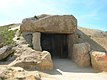 Entrance
 -
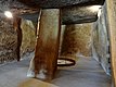
 View inside from the entrance
 -
 Back of the chamber with well
 -
 view inside the well
 -
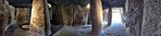 Panoramic view


See also
- List of megalithic sites
- Antequera Dolmens Site
- Dolmen de Viera
- Dolmen de Soto
References
Wikimedia Commons has media related to Dolmen of Menga.
- ^ "Antequera Dolmen Sites". Unesco.org. UNESCO. January 27, 2012. Archived from the original on September 5, 2015.
- ^ Journal for the History of Astronomy. Science History Publications. 1994. p. 556.
- ^ Dólmenes de Antequera, nuevaacropolismalaga.org. Accessed online 2010-01-23.
- ^ Conjunto Arqueológico Dólmenes de Antequera Archived June 15, 2011, at the Wayback Machine, Consejería de Cultura, Junta de Andalucía. Accessed online 2010-01-23.
- ^ Spanish Wikipedia https://es.wikipedia.org/wiki/Pe%C3%B1a_de_los_Enamorados
- ^ Crucial new data on the origin of the Dolmens of Antequera, a World Heritage Site https://www.sciencedaily.com/releases/2018/06/180628120046.htm
- v
- t
- e
- 1501-001: The Menga Dolmen and The Viera Dolmen
- 1501-002: Tholos of El Romeral
- 1501-003: Peña de los Enamorados
- 1501-004: El Torcal de Antequera
| Authority control databases |
|
|---|


