Eldon Range
Mountain range in Tasmania, Australia


Eldon Peak
Location in Tasmania, Australia
The Eldon Range is a mountain range located in the west coast region of Tasmania, Australia.
The range is located at the north eastern edge of Lake Burbury and is part of the Tasmanian Wilderness World Heritage Area which includes the Franklin-Gordon Wild Rivers National Park.[4]
The range is east of the main line of the West Coast Range and runs at right angle to it in a west–east direction. It is separated from that range by the King River valley and is bordered by the Eldon River to the north and west.
Naming
It is claimed that Henry Hellyer named the present day Mount Farrell near Tullah with this same name in 1828 after Lord Eldon Lord Chancellor of England.,[5][6] Charles Gould in 1869 gives this name to the range.[7]
Peaks
Eldon Peak (41°58′12″S 145°43′48″E / 41.97000°S 145.73000°E / -41.97000; 145.73000[2]) is a mountain that is the highest point on the range. The peak has an elevation of 1,440 metres (4,720 ft) above sea level,[2] and is the western peak, being number 23 of the Abels.[8]
The similarly named Eldon Bluff (41°58′S 145°49′E / 41.967°S 145.817°E / -41.967; 145.817) is the eastern peak. Eldon Bluff is 1,361 metres (4,465 ft) number 54 of The Abels.
A smaller peak to the south is known as the Little Eldons, with an elevation of 640 metres (2,100 ft) above sea level and it is separated from the Eldon Range by the South Eldon River. In the 1860s report of travels of Charles Gould, the Eldon range is mentioned.[9]
In the 1930s Eldon Peak was used as the starting point of a walk by F Smithies of Launceston and C Bradshaw of Linda.[10] In 1991 Crawford and Reid's climb is found described in Crawfords book on the King.[11]
Eldon Peak is one of the least visited peaks in Tasmania due to its remoteness. It was climbed in 1947 by Keith Lancaster, a Tasmanian bushwalker who recorded a cairn on the summit, indicating it was not the first European ascent.[12] Lancaster ascended from the King River valley, a route no longer possible due to the impoundment of the river. Modern approaches would be from the south-east or south arriving at Lake Ewart at the foot of Eldon Bluff. All approaches are over trackless terrain with patches of difficult scrub.
Part of the route from the south east follows the western border of the Cradle Mountain-Lake St Clair National Park, marked with poles by the bushman Charlie Spencer. Few of the poles still survive, and could not be relied upon. Navigation in this area would be extremely difficult in poor weather.
Gallery
-
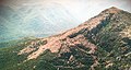 Eldon peak viewed from the south east
 -
 Eldon peak viewed from the north
 -
 Eldon peak viewed from the west


See also
 Australia portal
 Mountains portal


References
- ^ "Eldon Peak, Australia". Peakbagger.com. Retrieved 9 June 2015.
- ^ a b c "Eldon Peak (TAS)". Gazetteer of Australia online. Geoscience Australia, Australian Government.
- ^ "Eldon Range (TAS)". Gazetteer of Australia online. Geoscience Australia, Australian Government.
- ^ Jackson, Judy; Richardson, Graham (18 December 1989). "JOINT STATEMENT BY THE HON JUDY JACKSON AND SENATOR GRAHAM RICHARDSON WORLD HERITAGE FOR THE TASMANIAN WILDERNESS" (Press release). Parliament of Australia. Retrieved 9 June 2015.
- ^ Gunn, Ronald Campbell; Hellyer, Henry; Lyne, John; Mawle, William; Oakden, Philip; Parramore, William (2010). Reference to the index of miscellaneous items including letters, genealogy notes and copies of land grants of some prominent Tasmanian pioneers. University of Tasmania Library Special and Rare Materials Collection. Retrieved 9 June 2015.
- ^ Henry Hellyer; Edward Curr (1828), Miscellaneous Items Collection / Henry Hellyer Letter, retrieved 26 April 2023
- ^ Walker, James Backhouse (1993). Stoddart, D. M. (ed.). Walk to the West. Hobart: Published on behalf of the Royal Society of Tasmania by Artemis Pub. Consultants. ISBN 0-9598679-9-6.
- ^ Wilkinson, Bill (1994), The Abels : Tasmania's mountains over 1100m high, Regal Publications, ISBN 978-0-949457-67-7
- ^ "EXPLORATION OF WESTERN AND NORTH-WESTERN TASMANIA". Launceston Examiner. Vol. XX, no. 2288 and 94. Tasmania, Australia. 9 August 1860. p. 2 (AFTERNOON). Retrieved 26 April 2023 – via National Library of Australia.
- ^ "A Notable Mountaineering Exploit". The Advocate. Burnie, Tas.: National Library of Australia. 22 March 1932. p. 6. Retrieved 5 June 2015.
- ^ Crawford, Patsy (2000), King : the story of a river, Montpelier Press, ISBN 978-1-876597-02-3 see chapter titled On Eldon Peak pp 152-155
- ^ http://users.bigpond.net.au/dveltkamp/KeithLancaster/071HermitofGordonVale.htm Archived 20 December 2007 at the Wayback Machine Keith Lancaster's Mountaineering diaries
Further reading
- Charles Whitham Western Tasmania: A Land of Riches and Beauty
External links
- Tasmanian Wilderness World Heritage Area - Tasmania Parks and Wildlife Service
- v
- t
- e
Mountains in Tasmania, Australia
| Eastern |
|
|---|
- Legges Tor (1,572 m or 5,157 ft)
- Giblin Peak (1,569 m or 5,148 ft)
- Markham Heights (1,542 m or 5,059 ft)
- Hamilton Crags (1,540 m or 5,052 ft)
- Stacks Bluff (1,527 m or 5,010 ft)
- Misery Bluff (1,520 m or 4,987 ft)
- Ossian’s Throne (1,498 m or 4,915 ft)
- Coalmine Crag (1,498 m or 4,915 ft)
- Magnet Crag (1,464 m or 4,803 ft)
- Victoria (1,213 m or 3,980 ft)
- unnamed peak (1,520 m or 4,987 ft)
- Geryon North (1,516 m or 4,974 ft)
- Massif (1,514 m or 4,967 ft)
- Geryon South (1,509 m or 4,951 ft)
- Gould (1,485 m or 4,872 ft)
- Castle Crag (1,482 m or 4,862 ft)
- Thetis (1,482 m or 4,862 ft)
- The Acropolis (1,481 m or 4,859 ft)
- Achilles (1,363 m or 4,472 ft)
- Eldon Peak (1,440 m or 4,724 ft)
- Eldon Bluff
- Ironstone (1,443 m or 4,734 ft)
- Ossa (1,614 m or 5,295 ft)1
- Pelion West (1,560 m or 5,118 ft)
- Pelion East (1,461 m or 4,793 ft)
- Kunanyi / Wellington (1,269 m or 4,163 ft)
- Murchison (1,275 m or 4,183 ft)
- Jukes (1,168 m or 3,832 ft)
- Sedgwick (1,147 m or 3,763 ft)
- Owen (1,146 m or 3,760 ft)
- Sorell (1,144 m or 3,753 ft)
- Read (1,124 m or 3,688 ft)
- Proprietary Peak (1,103 m or 3,619 ft)
- Hamilton (1,103 m or 3,619 ft)
- Darwin (1,031 m or 3,383 ft)
| Heemskirk | |
|---|---|
| Sticht |
|
| Tyndall |
|
- Mount Olympus (1,472 m or 4,829 ft)
- Frenchmans Cap (1,446 m or 4,744 ft)
- Barrow (1,406 m or 4,613 ft)
1 Highest summit elevation in Tasmania
 Category
 Category


