Flat Fell


Flat Fell
Lake District, England
Flat Fell is a hill located on the edge of the English Lake District, standing at 272m. It is included in Alfred Wainwright's Outlying Fells of Lakeland book, sharing a chapter with Dent.[1] Wainwright's clockwise route to the two summits starts at Wath Brow.
Topography
Flat Fell has an elongated, slug-shaped profile, with a steep slope known as Flatfell Screes at the Eastern end. Flatfell Screes forms the one side of the valley of the Nannycatch Beck, along which runs part of the Coast to Coast Walk. Unlike Dent, Flat Fell is not forested and is mostly covered by open grassland, grazed by sheep and horses. The Southern and Eastern slopes are carpeted with large areas of bracken and Gorse (Ulex europaeus).
Ascent
Flat fell is flanked by two rights of way; a bridleway along the Southern slope and a footpath along the Northern aspect. The latter links to the Fell Road at the Kinniside Stone Circle. Both tracks link together at the end of Nannycatch road, to the West. There are no distinct paths leading from either track to the summit.
Summit and Views
The Summit of Flat Fell is marked by a cairn (not present at the time of Wainwright's visit) and provides extensive views over West Cumbria and the fells of Dent, Grike, Blakeley Raise and Lank Rigg
Gallery
-
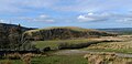
 The Summit of Flat Fell, looking East towards Grike, Blakeley Raise and Lank Rigg
 -
 East face of Flat Fell


References
- ^ Wainwright, A. (1974). "Flat Fell and Dent". The Outlying Fells of Lakeland. Kendal: Westmorland Gazette. pp. 198–201.
 Cumbria portal

- v
- t
- e
Wainwright's The Outlying Fells of Lakeland
for single summits
- Beacon Fell
- Bigland Barrow
- Black Combe
- Blawith Knott
- Boat How
- Brant Fell
- Burney
- Caermote Hill
- Carron Crag
- Cartmel Fell
- Caw
- Claife Heights
- Clints Crags
- Cold Fell
- Dunmallet
- Dunnerdale Fells
- Faulds Brow
- Finsthwaite Heights
- Hampsfell
- Great Worm Crag
- Green Quarter Fell
- Gummer's How
- Hesk Fell
- Heughscar Hill
- High Knott
- Howes
- Hugill Fell
- Humphrey Head
- Irton Pike
- Knipescar Common
- Latterbarrow
- Muncaster Fell
- Newton Fell
- Orrest Head
- Ponsonby Fell
- Potter Fell
- Reston Scar
- School Knott
- Scout Scar
- Seat Robert
- Stainton Pike
- Staveley Fell
- Stickle Pike
- Top o'Selside
- Walna Scar
- Watch Hill
- Whitbarrow
- Whit Fell
- Woodland Fell
for circuits, groups
and horseshoes


