Folsgare
Village in Friesland, Netherlands
Folsgare Folsgeare | |
|---|---|
Village | |
 | |
 Coat of arms | |
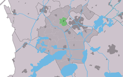 Location in the former Wymbritseradiel municipality | |
53°2′14″N 5°36′19″E / 53.03722°N 5.60528°E / 53.03722; 5.60528 | |
| Country |  Netherlands Netherlands |
| Province |  Friesland Friesland |
| Municipality |  Súdwest-Fryslân Súdwest-Fryslân |
| Area | |
| • Total | 3.83 km2 (1.48 sq mi) |
| Elevation | 0.2 m (0.7 ft) |
| Population (2021)[1] | |
| • Total | 335 |
| • Density | 87/km2 (230/sq mi) |
| Postal code | 8773[1] |
| Dialing code | 0515 |
Folsgare (West Frisian: Folsgeare) is a village in Súdwest-Fryslân in the province of Friesland, the Netherlands. It had a population of around 325 in January 2017.[3]
History
The village was first mentioned in the 13th century as Ffoldesgara and means "tapering pieces of land of Foldo (person)".[4] Folsgare is a terp (artificial living hill) village which developed in the middle ages.[5] It was located near the former Middelzee.[6] The village was well connected to the outside world by waterways.[5]
In 1498, Folsgare was attacked by the Vetkopers who burned down the church causing the death of two villagers who had been hiding in the tower. The current church dates from 1875.[5]
Folsgare was home to 141 people in 1840.[6] Before 2011, the village was part of the Wymbritseradiel municipality. In the 21st century, the city of Sneek has extended its industrial zone to close to the village.[6]
Gallery
-
 Farm in Folsgare
 -
 Church of Folsgare


References
- ^ a b c "Kerncijfers wijken en buurten 2021". Central Bureau of Statistics. Retrieved 5 April 2022.
- ^ "Postcodetool for 8773KK". Actueel Hoogtebestand Nederland (in Dutch). Het Waterschapshuis. Retrieved 5 April 2022.
- ^ Kerncijfers wijken en buurten 2017 - CBS Statline
- ^ "Folsgare - (geografische naam)". Etymologiebank (in Dutch). Retrieved 5 April 2022.
- ^ a b c "Folsgare - (geografische naam)". Friesland Wonderland (in Dutch). Retrieved 5 April 2022.
- ^ a b c "Folsgare". Plaatsengids (in Dutch). Retrieved 5 April 2022.
External links
![]() Media related to Folsgare at Wikimedia Commons
Media related to Folsgare at Wikimedia Commons
- v
- t
- e
Populated places in the municipality of Súdwest-Fryslân
- Bolsward
- Hindeloopen
- IJlst
- Sneek
- Stavoren
- Workum
- Abbegea
- Allingawier
- Arum
- Blauwhuis
- Boazum
- Breezanddijk
- Britswert
- Burgwerd
- Cornwerd
- Dearsum
- Dedgum
- Easterein
- Easterwierrum
- Exmorra
- Ferwoude
- Folsgare
- Gaast
- Gaastmeer
- Gauw
- Goënga
- Greonterp
- Hartwerd
- Heeg
- Hemelum
- Hichtum
- Hidaard
- Hieslum
- Hinnaard
- Hommerts
- Idsegahuizum
- Idzega
- Iens
- Indijk
- It Heidenskip
- Itens
- Jutrijp
- Kimswerd
- Kornwerderzand
- Koudum
- Koufurderrige
- Kûbaard
- Lollum
- Longerhouw
- Lytsewierrum
- Makkum
- Molkwerum
- Nijhuizum
- Nijland
- Oosthem
- Oppenhuizen
- Oudega
- Parrega
- Piaam
- Pingjum
- Poppenwier
- Reahûs
- Raerd
- Rien
- Sandfirden
- Scharl
- Scharnegoutum
- Schettens
- Schraard
- Sibrandabuorren
- Smallebrugge
- Tersoal
- Tirns
- Tjalhuizum
- Tjerkwerd
- Uitwellingerga
- Waaksens
- Warns
- Westhem
- Witmarsum
- Wiuwert
- Wolsum
- Wommels
- Wons
- Woudsend
- Ypecolsga
- Ysbrechtum
- Zurich
 | This Friesland location article is a stub. You can help Wikipedia by expanding it. |
- v
- t
- e


