George VI Ice Shelf
Ice shelf in Antarctica
You can help expand this article with text translated from the corresponding article in Swedish. (June 2012) Click [show] for important translation instructions.
- Machine translation, like DeepL or Google Translate, is a useful starting point for translations, but translators must revise errors as necessary and confirm that the translation is accurate, rather than simply copy-pasting machine-translated text into the English Wikipedia.
- Do not translate text that appears unreliable or low-quality. If possible, verify the text with references provided in the foreign-language article.
- You must provide copyright attribution in the edit summary accompanying your translation by providing an interlanguage link to the source of your translation. A model attribution edit summary is
Content in this edit is translated from the existing Swedish Wikipedia article at [[:sv:Georg VI:s shelfis]]; see its history for attribution. - You may also add the template
{{Translated|sv|Georg VI:s shelfis}}to the talk page. - For more guidance, see Wikipedia:Translation.
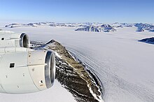
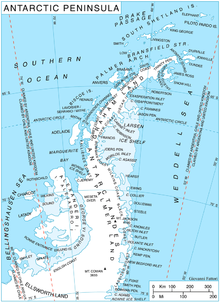
The George VI Ice Shelf (71°45′S 68°00′W / 71.750°S 68.000°W / -71.750; -68.000) is an extensive ice shelf that occupies George VI Sound which separates Alexander Island from Palmer Land in Antarctica. The ice shelf extends from Ronne Entrance, at the southwest end of the sound, to Niznik Island, about 30 nautical miles (56 km) south of the north entrance between Cape Brown and Cape Jeremy. It was named by the UK Antarctic Place-Names Committee in association with George VI Sound.[1]
History
The George VI shelf ice and George VI Strait were discovered in 1935 during a flight by Lincoln Ellsworth.
The area was explored by the British Graham Land Expedition in 1936–1937 led by John Riddoch Rymill and in 1940 by the American USAS.
In 1975, the name was determined by the American "Advisory Committee on Antarctic Names" (US-ACAN, a unit of the United States Geological Survey) and the British "Antarctic Place-Names Committee" (UK-APC, a unit of the Foreign and Commonwealth Office).[2]
Further reading
- J.Loynes, J.R.Potter, J.G.Paren, Current, temperature, and salinity beneath George VI Ice Shelf, Antarctica, Deep Sea Research Part A. Oceanographic Research Papers Volume 31, Issue 9, September 1984, Pages 1037-1055
- Jenkins, A., and S. Jacobs (2008), Circulation and melting beneath George VI Ice Shelf, Antarctica[permanent dead link], JOURNAL OF GEOPHYSICAL RESEARCH, VOL. 113, C04013, doi:10.1029/2007JC004449, 2008
- M.H. Talbot, OCEANIC ENVIRONMENT OF GEORGE VI ICE SHELF, ANTARCTIC PENINSULA Archived 31 October 2019 at the Wayback Machine, Annals of Glaciology 11 1988
- Millennial-Scale History of the George VI Ice Shelf, Antarctic Peninsula
- Bentley, M.J.; Hodgson, D.A. ; Sugden, D.E.; Roberts, S.J.; Smith, J.A.; Leng, M.J. ; Bryant, C. 2005, Early Holocene retreat of the George VI Ice Shelf, Antarctic Peninsula, Geology, 33 (3). 173–176. https://doi.org/10.1130/G21203.1
References
- ^ "George VI Ice Shelf". Geographic Names Information System. United States Geological Survey, United States Department of the Interior. Retrieved 22 April 2012.
- ^ "SCAR Composite Gazetteer". data.aad.gov.au. Retrieved 6 July 2023.
![]() This article incorporates public domain material from "George VI Ice Shelf". Geographic Names Information System. United States Geological Survey.
This article incorporates public domain material from "George VI Ice Shelf". Geographic Names Information System. United States Geological Survey.
- v
- t
- e
 | This Palmer Land location article is a stub. You can help Wikipedia by expanding it. |
- v
- t
- e


