Grade I listed buildings in Ceredigion

Map all coordinates using OpenStreetMap
Download coordinates as:
- KML
- GPX (all coordinates)
- GPX (primary coordinates)
- GPX (secondary coordinates)
In the United Kingdom, the term listed building refers to a building or other structure officially designated as being of special architectural, historical, or cultural significance; Grade I structures are those considered to be "buildings of exceptional interest".[1] Listing was begun by a provision in the Town and Country Planning Act 1947. Once listed, strict limitations are imposed on the modifications allowed to a building's structure or fittings. In Wales,[2] the authority for listing under the Planning (Listed Buildings and Conservation Areas) Act 1990[3] rests with Cadw.
Buildings
| Name | Location Grid Ref.[note 1] Geo-coordinates | Date Listed | Function | Notes | Reference Number | Image |
|---|---|---|---|---|---|---|
| St Gwenog Church, Llanwenog | Llanwenog SN4938945526 52°05′15″N 4°11′59″W / 52.087540925299°N 4.1996551595069°W / 52.087540925299; -4.1996551595069 (St Gwenog Church, Llanwenog) | 3 June 1964 | Church | Situated on E side of minor lane connecting B4338 and A475 some 750m WSW of Drefach.[4][5] | 9817 | 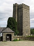 See more images |
| St Padarn's Church, Llanbadarn Fawr | Llanbadarn Fawr SN5990981012 52°24′33″N 4°03′39″W / 52.40913454502°N 4.0609502406201°W / 52.40913454502; -4.0609502406201 (St Padarn's Church, Llanbadarn Fawr) | 21 January 1964 | Church | Situated on a sloping site just W of The Square in the centre of the village.[6][7] | 9832 |  See more images |
| Nanteos | Llanfarian SN6201578629 52°23′18″N 4°01′44″W / 52.388261070129°N 4.0290277743815°W / 52.388261070129; -4.0290277743815 (Nanteos) | 12 February 1952 | Country House | Situated at the end of a long private drive which leads NE from the B4340.[8][9] | 9875 |  See more images |
| Church of St Michael, Penbryn | Penbryn SN2935952115 52°08′27″N 4°29′42″W / 52.140895617469°N 4.4950241840214°W / 52.140895617469; -4.4950241840214 (Church of St Michael, Penbryn) | 21 September 1964 | Church | Situated in circular hillside churchyard to W of Hoffnant valley some 500m inland from Penbryn beach.[10][11] | 9899 |  See more images |
| Strata Florida Abbey ruins | Ystrad Fflur SN7467665729 52°16′31″N 3°50′18″W / 52.275398853637°N 3.8382785335925°W / 52.275398853637; -3.8382785335925 (Strata Florida Abbey ruins) | 5 December 1963 | Abbey (ruin) | Situated about 1.5 km E of Pontrhydfendigaid on Abbey Road.[12][13] | 9913 |  See more images |
| Aberystwyth University Old College Building | Aberystwyth SN5806981707 52°24′54″N 4°05′18″W / 52.41490317435°N 4.0882762867696°W / 52.41490317435; -4.0882762867696 (Aberystwyth University Old College Building) | 21 July 1961 | College | Dominating the southern end of the town's seafront; railed and grassed forecourt to seaward side.[14][15] | 10251 |  See more images |
| Aberystwyth Castle | Aberystwyth SN5795681531 52°24′48″N 4°05′24″W / 52.413292583034°N 4.0898617670529°W / 52.413292583034; -4.0898617670529 (Aberystwyth Castle) | 14 September 1962 | Castle | Situated on a promontory SW of the town centre.[16][17] | 10313 |  See more images |
| Cardigan Castle | Cardigan SN1779245907 52°04′53″N 4°39′38″W / 52.081438273731°N 4.6605399362576°W / 52.081438273731; -4.6605399362576 (Cardigan Castle) | 16 June 1961 | Castle | Situated on promontory overlooking Cardigan Bridge.[18][19] | 10458 | 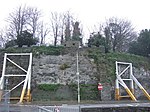 See more images |
| Llanerchaeron | Ciliau Aeron SN4792160197 52°13′08″N 4°13′39″W / 52.218937713672°N 4.2276366457559°W / 52.218937713672; -4.2276366457559 (Llanerchaeron) | 3 June 1964 | Country House | On S side of road, reached off A482. 3 km SE of Aberaeron.[20][21] | 10715 |  See more images |
| Church of the Holy Cross, Mwnt | Y Ferwig SN1950252015 52°08′13″N 4°38′20″W / 52.136855844053°N 4.638851998066°W / 52.136855844053; -4.638851998066 (Church of the Holy Cross, Mwnt) | 21 September 1964 | Church | Situated above and some 125m NW of Mwnt beach under Foel y Mwnt.[22][23] | 15874 |  See more images |
See also
 Wales portal

- Grade II* listed buildings in Ceredigion
- Listed buildings in Wales
- Scheduled monuments in Ceredigion
- Registered historic parks and gardens in Ceredigion
Notes
- ^ Sometimes known as OSGB36, the grid reference is based on the British national grid reference system used by the Ordnance Survey.
References
- ^ "Buildings & Conservation Areas". Cadw. Retrieved 18 June 2013.
- ^ "Coflein". online database of RCAHMW. Royal Commission on the Ancient and Historical Monuments of Wales. Retrieved 28 November 2016.
- ^ "Planning (Listed Buildings and Conservation Areas) Act 1990". The National Archives. Retrieved 18 June 2013.
- ^ Cadw. "St Gwenog Church (9817)". National Historic Assets of Wales. Retrieved 4 April 2019.
- ^ "St Gwenog Church". British Listed Buildings. Retrieved 4 April 2019.
- ^ Cadw. "Church of St Padarn (9832)". National Historic Assets of Wales. Retrieved 4 April 2019.
- ^ "Church of St Padarn". British Listed Buildings. Retrieved 4 April 2019.
- ^ Cadw. "Nanteos (9875)". National Historic Assets of Wales. Retrieved 4 April 2019.
- ^ "Nanteos". British Listed Buildings. Retrieved 4 April 2019.
- ^ Cadw. "Church of St Michael (9899)". National Historic Assets of Wales. Retrieved 4 April 2019.
- ^ "Church of St Michael". British Listed Buildings. Retrieved 4 April 2019.
- ^ Cadw. "Strata Florida Abbey ruins (9913)". National Historic Assets of Wales. Retrieved 4 April 2019.
- ^ "Strata Florida Abbey ruins". British Listed Buildings. Retrieved 4 April 2019.
- ^ Cadw. "University College of Wales Old College Building (10251)". National Historic Assets of Wales. Retrieved 4 April 2019.
- ^ "University College of Wales Old College Building". British Listed Buildings. Retrieved 4 April 2019.
- ^ Cadw. "Aberystwyth Castle (10313)". National Historic Assets of Wales. Retrieved 4 April 2019.
- ^ "Aberystwyth Castle". British Listed Buildings. Retrieved 4 April 2019.
- ^ Cadw. "Cardigan Castle (10458)". National Historic Assets of Wales. Retrieved 4 April 2019.
- ^ "Cardigan Castle". British Listed Buildings. Retrieved 4 April 2019.
- ^ Cadw. "Llanerchaeron, including rear Service Courtyard Ranges (previously listed as Llanaeron House) (10715)". National Historic Assets of Wales. Retrieved 4 April 2019.
- ^ "Llanerchaeron, including rear Service Courtyard Ranges (previously listed as Llanaeron House)". British Listed Buildings. Retrieved 4 April 2019.
- ^ Cadw. "Church of the Holy Cross (15874)". National Historic Assets of Wales. Retrieved 4 April 2019.
- ^ "Church of the Holy Cross". British Listed Buildings. Retrieved 4 April 2019.
External links
![]() Media related to Grade I listed buildings in Ceredigion at Wikimedia Commons
Media related to Grade I listed buildings in Ceredigion at Wikimedia Commons
- v
- t
- e
 Architecture
 Wales
Wales


