Haskeir
Island in Scotland
57°48′N 7°48′W / 57.8°N 7.8°W / 57.8; -7.8


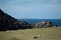
Haskeir Lighthouse, and Haskeir Eagach in the distance
Haskeir (Scottish Gaelic: Eilean Hasgeir), also known as Great Haskeir (Scottish Gaelic: Hasgeir Mhòr) is a remote, exposed and uninhabited island in the Outer Hebrides of Scotland. It lies 13 kilometres (8 miles) west-northwest of North Uist. 1 km (5⁄8 mi) southwest lie the skerries of Haskeir Eagach, made up of a colonnade of five rock stacks, and 40 km (25 mi) northwest is St Kilda.
Geography, geology and botany
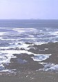
There is no anchorage or shelter and access via the steep rocky cliffs may be difficult, even in calm conditions. There are several natural rock arches and a high cliff on the northern end of the island called Castle Cliff. Various small skerries lie immediately to the north and south. There is very little vegetation save for a few sea-pinks, campion, plantain and orache that can survive the salt spray.[3]
Much of the bedrock is Lewisian gneiss[7]
History
Skilðar or Skilðir (meaning shields) may have been the Old Norse name for Haskeir.[1][2] Skildar certainly appears on a map by Nicholas de Nicolay from 1583. There are various theories that somehow the transposition of this name to nearby St Kilda may have created the name for this latter archipelago, whose origins are otherwise obscure.[8][9]
There is an active lighthouse on the island constructed in 1997 and operated by the Northern Lighthouse Board, as well as the remains of a bothy, possibly built by fishermen from the Monach Islands.
Gallery
-
 North east of Haskeir from Griminish, North Uist
 -
 Heisgeir Eagach from Rubha Ghriminis, North Uist
 -
 Haskeir (on the right) and Haskeir Eagach from Griminish Point, North Uist
 -


See also
 Scottish islands portal
 Scotland portal
 Engineering portal


- List of islands in Scotland
- List of lighthouses in Scotland
- List of Northern Lighthouse Board lighthouses
References
- ^ a b Maclean, Charles (1977) Island on the Edge of the World: the Story of St. Kilda Canongate. ISBN 0-903937-41-7. Page 33.
- ^ a b Fleming, Andrew (2005) St. Kilda and the Wider World: Tales of an Iconic Island. Windgather Press. ISBN 1-905119-00-3. Page 27. Maclean does not state which island caused the confusion, but Fleming equates 'Skilðir' with Haskeir.
- ^ a b Haswell-Smith, Hamish. (2004) The Scottish Islands. Edinburgh. Canongate.
- ^ Ordnance Survey "Get-a-Map"
- ^ Haskeir Lighthouse World of Lighthouses. Retrieved 19 May 2016
- ^ Rowlett, Russ. "Lighthouses of Scotland: Western Isles". The Lighthouse Directory. University of North Carolina at Chapel Hill. Retrieved 19 May 2016.
- ^ "The Lewisian Gneiss of North Castle, Haskeir:: OS grid NF6182 :: Geograph Britain and Ireland - photograph every grid square!". Geograph.org.uk. Retrieved 29 April 2012.
- ^ Quine, David (2000) St Kilda. Grantown-on-Spey. Colin Baxter Island Guides. ISBN 1-84107-008-4. Page 21. Quine, for example, suggests that Skildar was transcribed in error by Lucas J. Waghenaer in his 1592 charts without the trailing r and with a period after the S, creating S.Kilda. This was in turn assumed to stand for a saint by others, creating the form that has been used for several centuries, St Kilda.
- ^ de Nicolay, Nicholas (1583) Vraye & exacte description Hydrographique des costes maritimes d'Escosse & des Isles Orchades Hebrides avec partie d'Angleterre & d'Irlande servant a la navigation.[permanent dead link] Edinburgh. National Library of Scotland. Retrieved 22 December 2007.
External links
- Northern Lighthouse Board
- v
- t
- e
Uninhabited islands of the Hebrides
- Calbha Beag
- Calbha Mor
- Calve Island
- Cara
- Càrna
- Eileach an Naoimh
- Eilean an Ròin Mòr
- Eilean Dubh Mòr
- Eilean Fladday
- Eilean Horrisdale
- Eilean Ighe
- Eilean Macaskin
- Eilean Meadhonach
- Eilean Mhic Chrion
- Eilean Mòr
- Eilean Rìgh
- Eilean Tigh
- Eilean Trodday
- Eorsa
- Garbh Eileach
- Gruinard
- Gunna
- Handa
- Harlosh Island
- Horse Island
- Inch Kenneth
- Insh
- Isay
- Isle Martin
- Isle Ristol
- Little Colonsay
- Longa Island
- Longay
- Lunga
- Oldany Island
- Ornsay
- Oronsay
- Pabay
- Priest Island
- Scarba
- Shuna
- Staffa
- Tanera Beag
- Texa
- Torsa
- Wiay

- Barra Head
- Boreray
- Calbhaigh
- Ceabhaigh
- Ceallasaigh Beag
- Ceallasaigh Mòr
- Ceann Ear
- Ceann Iar
- Eilean Chaluim Chille
- Eilean Chearstaidh
- Eileanan Iasgaich
- Eilean Liubhaird
- Eilean Mhealasta
- Eilean Mhuire
- Ensay
- Fiaraidh
- Flodaigh
- Flodaigh Mòr
- Flodday
- Flodday
- Fodragaigh
- Fuaigh Beag
- Fuaigh Mòr
- Fuday
- Fuiay
- Garbh Eilean
- Gasker
- Gighay
- Groaigh
- Haskeir
- Haskeir Eagach
- Hellisay
- Hermetray
- Killegray
- Kirkibost
- Lingeigh
- Little Bernera
- Mingulay
- Muldoanich
- Orosay
- Oronsay
- Pabbay
- Pabaigh Mòr
- Ronay
- Sandray
- Scarp
- Seaforth Island
- Sgeotasaigh
- Sibhinis
- Shillay
- Soay Mòr
- Stromay
- Stockinish Island
- Stuley
- Sursaigh
- Tahay
- Taransay
- Trialabreac
- Torogaigh
- Vacsay
- Vallay
- Wiay
57°41′53″N 7°41′04″W / 57.69807°N 7.68447°W / 57.69807; -7.68447
| Authority control databases: Haskeir Lighthouse |
|
|---|


