Herrngiersdorf
You can help expand this article with text translated from the corresponding article in German. (March 2009) Click [show] for important translation instructions.
- View a machine-translated version of the German article.
- Machine translation, like DeepL or Google Translate, is a useful starting point for translations, but translators must revise errors as necessary and confirm that the translation is accurate, rather than simply copy-pasting machine-translated text into the English Wikipedia.
- Do not translate text that appears unreliable or low-quality. If possible, verify the text with references provided in the foreign-language article.
- You must provide copyright attribution in the edit summary accompanying your translation by providing an interlanguage link to the source of your translation. A model attribution edit summary is
Content in this edit is translated from the existing German Wikipedia article at [[:de:Herrngiersdorf]]; see its history for attribution. - You may also add the template
{{Translated|de|Herrngiersdorf}}to the talk page. - For more guidance, see Wikipedia:Translation.
Municipality in Bavaria, Germany

Coat of arms
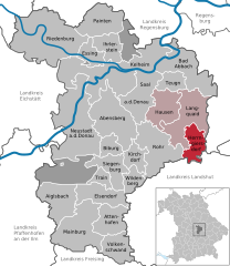
Location of Herrngiersdorf within Kelheim district
48°48′N 12°4′E / 48.800°N 12.067°E / 48.800; 12.067
(2022-12-31)[1]
84097
Herrngiersdorf is a municipality in the district of Kelheim in Bavaria in Germany. The village is dominated by the large, square Schloss Herrngiersdorf, a brewery.
Geography
Herrngiersdorf is located south of Langquaid and consists of Herrngiersdorf, Sandsbach, Semerskirchen, and Sittelsdorf.
Gallery
-
 Lake at Semerskirchen
 -
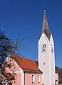 St. Martin's church
 -
 Schloss Herrngiersdorf


References
- ^ Genesis Online-Datenbank des Bayerischen Landesamtes für Statistik Tabelle 12411-003r Fortschreibung des Bevölkerungsstandes: Gemeinden, Stichtag (Einwohnerzahlen auf Grundlage des Zensus 2011).
Wikimedia Commons has media related to Herrngiersdorf.
Wikivoyage has a travel guide for Herrngiersdorf.
- v
- t
- e
Towns and municipalities in Kelheim (district)

Authority control databases | |
|---|---|
| International |
|
| National |
|
 | This Kelheim district location article is a stub. You can help Wikipedia by expanding it. |
- v
- t
- e


