Khorrambid County
County in Fars province, Iran
County in Fars, Iran
Khorrambid County Persian: شهرستان خرمبید | |
|---|---|
County | |
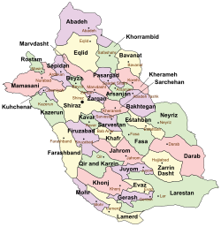 Location of Khorrambid County in Fars province (top right, green) | |
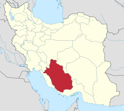 Location of Fars province in Iran | |
| Coordinates: 30°33′30″N 53°06′00″E / 30.55833°N 53.10000°E / 30.55833; 53.10000[1] | |
| Country |  Iran Iran |
| Province | Fars |
| Capital | Safashahr |
| Districts | Central, Mashhad-e Morghab |
| Population (2016)[2] | |
| • Total | 50,522 |
| Time zone | UTC+3:30 (IRST) |
| Khorrambid County can be found at GEOnet Names Server, at this link, by opening the Advanced Search box, entering "9206476" in the "Unique Feature Id" form, and clicking on "Search Database". | |
Khorrambid County (Persian: شهرستان خرمبید) is in Fars province, Iran. Its capital is the city of Safashahr.[3]
At the 2006 census, the county's population was 44,669 in 31,291 households.[4] The following census in 2011 counted 50,252 people in 13,561 households.[5] At the 2016 census, the county's population was 50,522 in 15,080 households.[2]
Administrative divisions
The population history of Khorrambid County's administrative divisions over three consecutive censuses is shown in the following table. The latest census shows two districts, three rural districts, and two cities.[2]
| Administrative Divisions | 2006[4] | 2011[5] | 2016[2] |
|---|---|---|---|
| Central District | 26,996 | 31,261 | 32,172 |
| Khorrami RD | 1,218 | 1,317 | 1,294 |
| Qeshlaq RD | 3,524 | 3,853 | 3,945 |
| Safashahr (city) | 22,254 | 26,091 | 26,933 |
| Mashhad-e Morghab District | 17,673 | 18,991 | 18,350 |
| Shahidabad RD | 3,578 | 3,199 | 3,377 |
| Qaderabad (city) | 14,095 | 15,792 | 14,973 |
| Total | 44,669 | 50,252 | 50,522 |
| RD = Rural District | |||
Wikimedia Commons has media related to Khorrambid County.
 Iran portal

References
- ^ OpenStreetMap contributors (23 September 2023). "Khorrambid County" (Map). OpenStreetMap. Retrieved 23 September 2023.
- ^ a b c d "Census of the Islamic Republic of Iran, 1395 (2016)". AMAR (in Persian). The Statistical Center of Iran. p. 07. Archived from the original (Excel) on 6 April 2022. Retrieved 19 December 2022.
- ^ Habibi, Hassan (24 February 1376). "Making changes in the scope of country divisions in Fars province". Lamtakam (in Persian). Ministry of Interior, Council of Ministers. Archived from the original on 9 December 2023. Retrieved 9 December 2023.
- ^ a b "Census of the Islamic Republic of Iran, 1385 (2006)". AMAR (in Persian). The Statistical Center of Iran. p. 07. Archived from the original (Excel) on 20 September 2011. Retrieved 25 September 2022.
- ^ a b "Census of the Islamic Republic of Iran, 1390 (2011)". Syracuse University (in Persian). The Statistical Center of Iran. p. 07. Archived from the original (Excel) on 16 January 2023. Retrieved 19 December 2022.
- v
- t
- e
Fars Province, Iran

and cities
- Afif-Abad Garden
- Amir's dam
- Arg of Karim Khan
- Barmdelak lagoon
- Bishapur
- Delgosha Garden
- Eram Garden
- Istakhr
- Ghal'eh Dokhtar
- Ka'ba-ye Zartosht
- Kazerun fire temple
- Lake Parishan
- Naqsh-e Rajab
- Naqsh-e Rustam
- Palace of Ardashir
- Sangtarashan cave
- Pars Museum
- Pasargadae
- Persepolis
- Qavam House
- Qur'an Gate
- Saadi's mausoleum
- Sarvestan Sassanian palace
- Shah Cheragh
- Colossal Statue of Shapur I in Shapur cave
- Tangeh Bolaghi
- Tomb of Ali ibn Hamzah, Shiraz
- Hāfezieh
- Tomb of Seyed Alaeddin Husayn
- Tounbbot
- Vakil Bath
- Vakil Bazaar
- Vakil Mosque
Khorrambid County | |||||||||||||||||||
|---|---|---|---|---|---|---|---|---|---|---|---|---|---|---|---|---|---|---|---|
| Capital | |||||||||||||||||||
| Districts |
| ||||||||||||||||||
 | This Fars Province location article is a stub. You can help Wikipedia by expanding it. |
- v
- t
- e


