La Selle-en-Coglès
Part of Les Portes du Coglais in Brittany, France
La Selle-en-Coglès Kell-Gougleiz | |
|---|---|
Part of Les Portes du Coglais | |
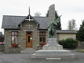 The town hall of La Selle-en-Coglès | |
Location of La Selle-en-Coglès  | |
48°26′18″N 1°20′36″W / 48.4383°N 1.3433°W / 48.4383; -1.3433 | |
| Country | France |
| Region | Brittany |
| Department | Ille-et-Vilaine |
| Arrondissement | Fougères-Vitré |
| Canton | Antrain |
| Commune | Les Portes du Coglais |
| Area 1 | 8.23 km2 (3.18 sq mi) |
| Population (2019)[1] | 583 |
| • Density | 71/km2 (180/sq mi) |
| Time zone | UTC+01:00 (CET) |
| • Summer (DST) | UTC+02:00 (CEST) |
| Postal code | 35460 |
| Elevation | 93–138 m (305–453 ft) |
| 1 French Land Register data, which excludes lakes, ponds, glaciers > 1 km2 (0.386 sq mi or 247 acres) and river estuaries. | |
La Selle-en-Coglès (French pronunciation: [la sɛl ɑ̃ kɔɡl], pronounced as La Selle-en-Cogles; Breton: Kell-Gougleiz) is a former commune in the Ille-et-Vilaine department in Brittany in northwestern France. On 1 January 2017, it was merged into the new commune Les Portes du Coglais.[2]
Population
Inhabitants of La Selle-en-Coglès are called Cellois in French.
| Year | Pop. | ±% |
|---|---|---|
| 1962 | 589 | — |
| 1968 | 580 | −1.5% |
| 1975 | 510 | −12.1% |
| 1982 | 491 | −3.7% |
| 1990 | 461 | −6.1% |
| 1999 | 447 | −3.0% |
| 2009 | 586 | +31.1% |
See also
References
External links
Wikimedia Commons has media related to La Selle-en-Coglès.
- Base Mérimée: Search for heritage in the commune, Ministère français de la Culture. (in French)
| Authority control databases: National |
|
|---|
- v
- t
- e


