List of Category A listed buildings in South Ayrshire
Map all coordinates using OpenStreetMap
Download coordinates as:
- KML
- GPX (all coordinates)
- GPX (primary coordinates)
- GPX (secondary coordinates)
This is a list of Category A listed buildings in the South Ayrshire council area in south-west Scotland.
In Scotland, the term listed building refers to a building or other structure officially designated as being of "special architectural or historic interest".[1] Category A structures are those considered to be "buildings of national or international importance, either architectural or historic, or fine little-altered examples of some particular period, style or building type."[2] Listing was begun by a provision in the Town and Country Planning (Scotland) Act 1947, and the current legislative basis for listing is the Planning (Listed Buildings and Conservation Areas) (Scotland) Act 1997.[3] The authority for listing rests with Historic Scotland, an executive agency of the Scottish Government, which inherited this role from the Scottish Development Department in 1991. Once listed, severe restrictions are imposed on the modifications allowed to a building's structure or its fittings. Listed building consent must be obtained from local authorities prior to any alteration to such a structure.[3] There are approximately 47,400 listed buildings in Scotland, of which around 8% (some 3,800) are Category A.[4]
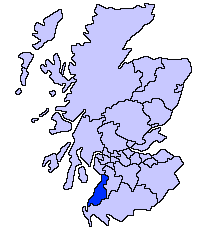
The council area of South Ayrshire covers 1,222 square kilometres (472 sq mi), and has a population of around 111,700. There are 75 Category A listed buildings in the area.
Listed buildings
| Name | Location | Date Listed | Grid Ref. [note 1] | Geo-coordinates | Notes | LB Number [note 2] | Image |
|---|---|---|---|---|---|---|---|
| Oswald Hall | Auchincruive Ayr | NS3877323468 | 55°28′42″N 4°33′09″W / 55.478369°N 4.55263°W / 55.478369; -4.55263 (Oswald Hall) | [5] | 99 | 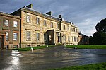 Upload another image | |
| Dalquharran Castle | Dailly | NS2705502161 | 55°16′59″N 4°43′29″W / 55.283127°N 4.724627°W / 55.283127; -4.724627 (Dalquharran Castle) | [6] | 125 |  Upload another image | |
| Kennedy Aisle | Ballantrae | NX0837982444 | 55°05′57″N 5°00′18″W / 55.099287°N 5.004894°W / 55.099287; -5.004894 (Kennedy Aisle) | [7] | 869 | 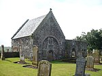 Upload another image | |
| Auchans Castle | Dundonald | NS3548034599 | 55°34′38″N 4°36′41″W / 55.577185°N 4.61129°W / 55.577185; -4.61129 (Auchans Castle) | [8] | 984 | 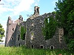 Upload another image | |
| Fairlie House | Dundonald | NS3852035973 | 55°35′26″N 4°33′50″W / 55.590535°N 4.563926°W / 55.590535; -4.563926 (Fairlie House) | [9] | 985 |  Upload Photo | |
| Lodge, Fairlie House | Dundonald | NS3885335667 | 55°35′16″N 4°33′30″W / 55.587899°N 4.558469°W / 55.587899; -4.558469 (Lodge, Fairlie House) | [10] | 987 | Upload Photo | |
| Laigh Milton Viaduct | Gatehead, over River Irvine[note 3] | NS3834936902 | 55°35′56″N 4°34′02″W / 55.598818°N 4.567181°W / 55.598818; -4.567181 (Laigh Milton Viaduct) | [11] | 990 |  Upload another image | |
| Auchincruive Estate, Oswald's Temple (Tea House) | Auchincruive, Ayr | NS3821523702 | 55°28′49″N 4°33′42″W / 55.480285°N 4.561585°W / 55.480285; -4.561585 (Auchincruive Estate, Oswald's Temple (Tea House)) | [12] | 996 | 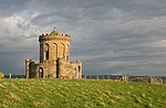 Upload another image | |
| Kildonan House | Barrhill | NX2275883095 | 55°06′38″N 4°46′49″W / 55.110478°N 4.78024°W / 55.110478; -4.78024 (Kildonan House) | [13] | 1052 | 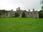 Upload another image | |
| Kilkerran House | Dailly | NS3046403051 | 55°17′32″N 4°40′18″W / 55.292301°N 4.671553°W / 55.292301; -4.671553 (Kilkerran House) | [14] | 1114 |  Upload another image | |
| Drumburle | Dailly | NS2894603089 | 55°17′32″N 4°41′44″W / 55.292117°N 4.695454°W / 55.292117; -4.695454 (Drumburle) | [15] | 1119 | Upload Photo | |
| Penkill Castle | Old Dailly | NX2315198538 | 55°14′57″N 4°47′01″W / 55.249224°N 4.783739°W / 55.249224; -4.783739 (Penkill Castle) | [16] | 1148 | 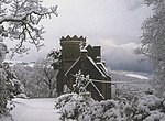 Upload another image | |
| Bargany House | Old Dailly | NS2438900245 | 55°15′54″N 4°45′55″W / 55.264987°N 4.765353°W / 55.264987; -4.765353 (Bargany House) | [17] | 1171 |  Upload another image | |
| Killochan Castle | Old Dailly | NS2272400325 | 55°15′54″N 4°47′30″W / 55.265109°N 4.791573°W / 55.265109; -4.791573 (Killochan Castle) | [18] | 1173 |  Upload another image | |
| Stables, Killochan Castle | Old Dailly | NS2271200348 | 55°15′55″N 4°47′30″W / 55.265311°N 4.791776°W / 55.265311; -4.791776 (Stables, Killochan Castle) | [19] | 1174 | Upload Photo | |
| Wallace's Monument | Barnweill, Symington | NS3415229006 | 55°31′36″N 4°37′44″W / 55.526532°N 4.628975°W / 55.526532; -4.628975 (Wallace's Monument) | [20] | 4856 |  Upload another image | |
| 3 Grey Gables | Monkton, Southwood Road | NS3415229006 | 55°31′36″N 4°37′44″W / 55.526532°N 4.628975°W / 55.526532; -4.628975 (3 Grey Gables) | [21] | 6385 | Upload Photo | |
| Ballantrae Windmill | Mill Hill, Ballantrae | NX0902783221 | 55°06′23″N 4°59′43″W / 55.106509°N 4.995275°W / 55.106509; -4.995275 (Ballantrae Windmill) | [22] | 6634 |  Upload another image | |
| Dovecote, Drumfad | Kirkmichael | NS3612308048 | 55°20′21″N 4°35′08″W / 55.339073°N 4.585452°W / 55.339073; -4.585452 (Dovecote, Drumfad) | [23] | 7558 | Upload Photo | |
| Kirkoswald Parish Church | Kirkoswald, Kirk Road | NS2396807369 | 55°19′44″N 4°46′35″W / 55.328776°N 4.776435°W / 55.328776; -4.776435 (Kirkoswald Parish Church) | [24] | 7583 | 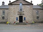 Upload another image | |
| Souter Johnnie's Cottage | Kirkoswald | NS2400707538 | 55°19′49″N 4°46′33″W / 55.330307°N 4.775927°W / 55.330307; -4.775927 (Souter Johnnie's Cottage) | [25] | 7586 |  Upload another image | |
| Baltersan Castle | Maybole | NS2825208760 | 55°20′34″N 4°42′35″W / 55.342776°N 4.709842°W / 55.342776; -4.709842 (Baltersan Castle) | [26] | 7588 |  Upload another image | |
| Crossraguel Abbey | Maybole | NS2753908334 | 55°20′19″N 4°43′15″W / 55.338703°N 4.720809°W / 55.338703; -4.720809 (Crossraguel Abbey) | [27] | 7589 |  Upload another image | |
| Culzean Castle | Maybole | NS2326510285 | 55°21′17″N 4°47′22″W / 55.354695°N 4.789342°W / 55.354695; -4.789342 (Culzean Castle) | [28] | 7595 |  Upload another image | |
| Home Farm, Culzean Castle | Maybole | NS2370110404 | 55°21′21″N 4°46′57″W / 55.355919°N 4.782549°W / 55.355919; -4.782549 (Home Farm, Culzean Castle) | [29] | 7596 |  Upload another image | |
| Camellia House, Culzean Castle | Maybole | NS2323710020 | 55°21′08″N 4°47′23″W / 55.352306°N 4.789616°W / 55.352306; -4.789616 (Camellia House, Culzean Castle) | [30] | 7597 |  Upload another image | |
| Hoolity Ha' Lodge, Culzean Castle | Maybole | NS2413510317 | 55°21′19″N 4°46′32″W / 55.355294°N 4.775657°W / 55.355294; -4.775657 (Hoolity Ha' Lodge, Culzean Castle) | [31] | 7603 |  Upload another image | |
| Aviaries and Swan Cottage, Culzean Castle | Maybole | NS2246409511 | 55°20′51″N 4°48′05″W / 55.347459°N 4.801469°W / 55.347459; -4.801469 (Aviaries and Swan Cottage, Culzean Castle) | [32] | 7605 |  Upload another image | |
| Culzean Castle, Bath House | Maybole | NS2301310158 | 55°21′15″N 4°47′38″W / 55.354046°N 4.7938317°W / 55.354046; -4.7938317 (Culzean Castle, Bath House) | [33] | 7609 | Upload Photo | |
| Culzean Castle walled garden | Maybole | 14 April 1971 | NS2312609845 | 55°21′04″N 4°47′29″W / 55.351228°N 4.7913373°W / 55.351228; -4.7913373 (Culzean Castle walled garden) | [34] | 7612 |  Upload another image |
| Gate Piers at Swinston Lodge, Culzean Castle | Maybole | NS2289509234 | 55°20′42″N 4°47′40″W / 55.345129°N 4.794506°W / 55.345129; -4.794506 (Gate Piers at Swinston Lodge, Culzean Castle) | [35] | 7614 | 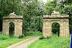 Upload another image | |
| Cassillis Castle | Dalrymple | NS3404512819 | 55°22′52″N 4°37′16″W / 55.381201°N 4.621009°W / 55.381201; -4.621009 (Cassillis Castle) | [36] | 13655 | 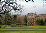 Upload another image | |
| Ruined Church of St. Cuthbert | Monkton | NS3580927688 | 55°30′55″N 4°36′07″W / 55.515262°N 4.601973°W / 55.515262; -4.601973 (Ruined Church of St. Cuthbert) | [37] | 14251 |  Upload another image | |
| Windmill, Whiteside | Monkton Windmill | NS3620928048 | 55°31′07″N 4°35′45″W / 55.518628°N 4.595858°W / 55.518628; -4.595858 (Windmill, Whiteside) | [38] | 14252 |  Upload another image | |
| Macrae Monument | Monkton | NS3654128257 | 55°31′14″N 4°35′27″W / 55.520615°N 4.590729°W / 55.520615; -4.590729 (Macrae Monument) | [39] | 14253 |  Upload another image | |
| Newark Castle | Alloway | NS3224617377 | 55°25′17″N 4°39′08″W / 55.421502°N 4.652111°W / 55.421502; -4.652111 (Newark Castle) | [40] | 14300 | Upload Photo | |
| Tarbolton Parish Church | Tarbolton, Cunningham Street | NS4302427172 | 55°30′47″N 4°29′15″W / 55.513003°N 4.487535°W / 55.513003; -4.487535 (Tarbolton Parish Church) | [41] | 14349 | 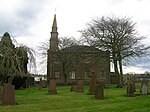 Upload another image | |
| Neilshill House | Mossblown | NS4091226179 | 55°30′12″N 4°31′13″W / 55.503406°N 4.520376°W / 55.503406; -4.520376 (Neilshill House) | [42] | 14355 | Upload Photo | |
| Parish Church and Graveyard | Symington, Main Street | NS3843631418 | 55°32′59″N 4°33′45″W / 55.54962°N 4.562592°W / 55.54962; -4.562592 (Parish Church and Graveyard) | [43] | 14357 |  Upload another image | |
| Coodham House | Symington | NS3958532659 | 55°33′40″N 4°32′42″W / 55.56114°N 4.545119°W / 55.56114; -4.545119 (Coodham House) | [44] | 14368 | 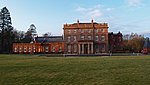 Upload another image | |
| Straiton Parish Church | Straiton, Main Street | NS3805904907 | 55°18′41″N 4°33′11″W / 55.311518°N 4.553147°W / 55.311518; -4.553147 (Straiton Parish Church) | [45] | 19089 |  Upload another image | |
| Blairquhan | Straiton | NS3653105468 | 55°18′58″N 4°34′39″W / 55.316049°N 4.577522°W / 55.316049; -4.577522 (Blairquhan) | [46] | 19094 |  Upload another image | |
| Burns Bachelors' Club | Tarbolton, Sandgate Street | NS4310027190 | 55°30′47″N 4°29′11″W / 55.513189°N 4.486343°W / 55.513189; -4.486343 (Burns Bachelors' Club) | [47] | 19689 |  Upload another image | |
| Alloway Auld Kirk | Alloway | NS3319118051 | 55°25′40″N 4°38′15″W / 55.427874°N 4.637601°W / 55.427874; -4.637601 (Alloway Auld Kirk) | [48] | 21470 |  Upload another image | |
| Brig o' Doon | Alloway | NS3324117836 | 55°25′33″N 4°38′12″W / 55.425961°N 4.636683°W / 55.425961; -4.636683 (Brig o' Doon) | [49] | 21474 |  Upload another image | |
| Robert Burns' Cottage | Alloway | NS3347418591 | 55°25′58″N 4°38′00″W / 55.432817°N 4.633457°W / 55.432817; -4.633457 (Robert Burns' Cottage) | [50] | 21476 | 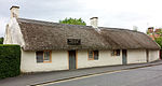 Upload another image | |
| Robert Burns Monument | Alloway | NS3323917945 | 55°25′37″N 4°38′12″W / 55.426939°N 4.63678°W / 55.426939; -4.63678 (Robert Burns Monument) | [51] | 21477 |  Upload another image | |
| Auld Brig over River Ayr | Ayr | NS3385922113 | 55°27′52″N 4°37′46″W / 55.464562°N 4.629483°W / 55.464562; -4.629483 (Auld Brig over River Ayr) | [52] | 21495 | 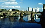 Upload another image | |
| Barns House | Ayr, Barns Crescent | NS3360321562 | 55°27′34″N 4°38′00″W / 55.459529°N 4.633197°W / 55.459529; -4.633197 (Barns House) | [53] | 21496 | Upload Photo | |
| Ayrshire Management Centre (Craigie House) | Craigie, Ayr | NS3496921386 | 55°27′30″N 4°36′41″W / 55.458412°N 4.611514°W / 55.458412; -4.611514 (Ayrshire Management Centre (Craigie House)) | [54] | 21556 | 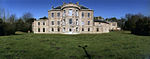 Upload another image | |
| Holy Trinity Church | Ayr, Fullarton Street | NS3362621762 | 55°27′41″N 4°37′59″W / 55.461332°N 4.632954°W / 55.461332; -4.632954 (Holy Trinity Church) | [55] | 21586 | 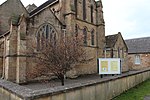 Upload another image | |
| Auld Kirk of Ayr | Ayr, Kirk Port | NS3390021920 | 55°27′46″N 4°37′43″W / 55.462843°N 4.62872°W / 55.462843; -4.62872 (Auld Kirk of Ayr) | [56] | 21653 |  Upload another image | |
| Auld Kirk of Ayr Gateway | Ayr, Kirk Port | NS3386521943 | 55°27′47″N 4°37′45″W / 55.463038°N 4.629286°W / 55.463038; -4.629286 (Auld Kirk of Ayr Gateway) | [57] | 21654 |  Upload another image | |
| Loudoun Hall | Ayr, Boat Vennal | NS3366122149 | 55°27′53″N 4°37′57″W / 55.464818°N 4.632632°W / 55.464818; -4.632632 (Loudoun Hall) | [58] | 21656 |  Upload another image | |
| 1 and 3 New Bridge Street | Ayr | NS3373922151 | 55°27′54″N 4°37′53″W / 55.464862°N 4.631401°W / 55.464862; -4.631401 (1 and 3 New Bridge Street) | [59] | 21689 |  Upload another image | |
| Town Buildings | Ayr, New Bridge Street | NS3370922080 | 55°27′51″N 4°37′55″W / 55.464215°N 4.631833°W / 55.464215; -4.631833 (Town Buildings) | [60] | 21692 |  Upload another image | |
| 34 New Bridge Street | Ayr | NS3365822081 | 55°27′51″N 4°37′58″W / 55.464206°N 4.632639°W / 55.464206; -4.632639 (34 New Bridge Street) | [61] | 21700 | Upload Photo | |
| Rozelle House | Ayr | NS3380418987 | 55°26′11″N 4°37′43″W / 55.436484°N 4.628484°W / 55.436484; -4.628484 (Rozelle House) | [62] | 21763 | Upload Photo | |
| Queen's Court House | Ayr, Sandgate | NS3363821990 | 55°27′48″N 4°37′58″W / 55.463383°N 4.632901°W / 55.463383; -4.632901 (Queen's Court House) | [63] | 21777 | Upload Photo | |
| 22 Sandgate (Lady Cathcart's House) | Ayr | NS3361222034 | 55°27′50″N 4°38′00″W / 55.463769°N 4.633338°W / 55.463769; -4.633338 (22 Sandgate (Lady Cathcart's House)) | [64] | 21788 |  Upload another image | |
| Savoy Croft | Ayr, Savoy Park | NS3325621193 | 55°27′22″N 4°38′18″W / 55.456099°N 4.638457°W / 55.456099; -4.638457 (Savoy Croft) | [65] | 21795 | Upload Photo | |
| Sheriff Court | Ayr, Wellington Square | NS3326221771 | 55°27′41″N 4°38′19″W / 55.461289°N 4.638709°W / 55.461289; -4.638709 (Sheriff Court) | [66] | 21820 |  Upload another image | |
| Collegiate Church | Maybole, Abbot Street | NS3016509876 | 55°21′12″N 4°40′49″W / 55.353458°N 4.68039°W / 55.353458; -4.68039 (Collegiate Church) | [67] | 37688 |  Upload another image | |
| Maybole Castle | Maybole | NS3013010029 | 55°21′17″N 4°40′52″W / 55.354819°N 4.681034°W / 55.354819; -4.681034 (Maybole Castle) | [68] | 37709 |  Upload another image | |
| St John's Cottage | Maybole | NS3082010179 | 55°21′23″N 4°40′13″W / 55.356404°N 4.670254°W / 55.356404; -4.670254 (St John's Cottage) | [69] | 37718 | Upload Photo | |
| Mercat Cross | Prestwick | NS3517526176 | 55°30′05″N 4°36′40″W / 55.501477°N 4.611103°W / 55.501477; -4.611103 (Mercat Cross) | [70] | 40328 |  Upload another image | |
| Salt Pan Houses at St Nicholas Golf Course | Prestwick | NS3435625001 | 55°29′26″N 4°37′24″W / 55.490653°N 4.623353°W / 55.490653; -4.623353 (Salt Pan Houses at St Nicholas Golf Course) | [71] | 40332 |  Upload another image | |
| Piersland House Hotel (formerly Piersland Lodge) | Troon, Craigend Road | NS3305429882 | 55°32′02″N 4°38′49″W / 55.534021°N 4.646877°W / 55.534021; -4.646877 (Piersland House Hotel (formerly Piersland Lodge)) | [72] | 42114 | Upload Photo | |
| Catholic Church of Our Lady of the Assumption and St Meddan | Troon, St Meddans Street | NS3268431125 | 55°32′42″N 4°39′13″W / 55.545051°N 4.653485°W / 55.545051; -4.653485 (Catholic Church of Our Lady of the Assumption and St Meddan) | [73] | 42129 |  Upload another image | |
| St Quivox Parish Church, Mausoleum | St Quivox, Ayr | NS3753224051 | 55°28′59″N 4°34′21″W / 55.483192°N 4.572585°W / 55.483192; -4.572585 (St Quivox Parish Church, Mausoleum) | [74] | 47011 | 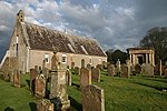 Upload another image | |
| St Quivox Parish Church | St Quivox, Ayr | NS3751324064 | 55°29′00″N 4°34′22″W / 55.483302°N 4.572893°W / 55.483302; -4.572893 (St Quivox Parish Church) | [75] | 48638 |  Upload another image | |
| Culzean Castle Courtyard | Maybole | 14 April 1971 | NS2331810298 | 55°21′17″N 4°47′19″W / 55.354831°N 4.788515°W / 55.354831; -4.788515 (Culzean Castle Courtyard) | [76] | 51823 | 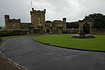 Upload another image |
| Culzean Castle Estate, Fountain Court | Maybole | 14 April 1971 | NS2330710221 | 55°21′15″N 4°47′19″W / 55.354136°N 4.788640°W / 55.354136; -4.788640 (Culzean Castle Estate, Fountain Court) | [77] | 51824 |  Upload another image |
| Culzean Castle Estate, Ruined Arch | Maybole | 14 April 1971 | NS2342110192 | 55°21′14″N 4°47′13″W / 55.353917°N 4.786826°W / 55.353917; -4.786826 (Culzean Castle Estate, Ruined Arch) | [78] | 51827 |  Upload another image |
| Culzean Castle Estate, Stable Court | Maybole | 14 April 1971 | NS 23365 10333 | 55°21′19″N 4°47′16″W / 55.355162°N 4.787797°W / 55.355162; -4.787797 (Culzean Castle Estate, Stable Court) | [79] | 51829 |  Upload another image |
See also
Notes
- ^ Sometimes known as OSGB36, the grid reference (where provided) is based on the British national grid reference system used by the Ordnance Survey.
• "Guide to National Grid". Ordnance Survey. Retrieved 12 December 2007.
• "Get-a-map". Ordnance Survey. Retrieved 17 December 2007. - ^ Historic Environment Scotland assign a unique alphanumeric identifier to each designated site in Scotland, for listed buildings this always begins with "LB", for example "LB12345".
- ^ Also in East Ayrshire, as it crosses the River Irvine which is the council boundary
References
- ^ Guide to the Protection of Scotland's Listed Buildings (PDF). Historic Scotland. 2009. p. 4. ISBN 978-1-84917-013-0. Retrieved 5 May 2010.
- ^ "What is Listing?". Historic Scotland. Retrieved 5 May 2010.
- ^ a b Scottish Historic Environment Policy (PDF). Historic Scotland. October 2008. pp. 24–25. ISBN 978-1-84917-002-4. Retrieved 5 May 2010.
- ^ Guide to the Protection of Scotland’s Listed Buildings, p. 17.
- ^ "Auchincruive Estate, Oswald Hall: Listed Building Report". Historic Scotland.
- ^ "Dalquharran Castle Including Stable Range: Listed Building Report". Historic Scotland.
- ^ "Remains Of Former Church: Listed Building Report". Historic Scotland.
- ^ "Auchans Castle: Listed Building Report". Historic Scotland.
- ^ "Fairlie House: Listed Building Report". Historic Scotland.
- ^ "Lodge, Fairlie: Listed Building Report". Historic Scotland.
- ^ "West Gatehead, Laigh Milton Viaduct: Listed Building Report". Historic Scotland.
- ^ "Auchincruive Estate, Oswald's Temple (Tea House): Listed Building Report". Historic Scotland.
- ^ "Kildonan House: Listed Building Report". Historic Scotland.
- ^ "Kilkerran House: Listed Building Report". Historic Scotland.
- ^ "Drumburle: Listed Building Report". Historic Scotland.
- ^ "Penkill Castle: Listed Building Report". Historic Scotland.
- ^ "Bargany House: Listed Building Report". Historic Scotland.
- ^ "Killochan Castle: Listed Building Report". Historic Scotland.
- ^ "Stables Killochan Castle: Listed Building Report". Historic Scotland.
- ^ "Barnweill, Wallace's Monument: Listed Building Report". Historic Scotland.
- ^ "Monkton, Southwood Road,3 Grey Gables Including Gatepiers, Terraced Garden And Garden Features: Listed Building Report". Historic Scotland.
- ^ "Old Windmill, Mill Hill: Listed Building Report". Historic Scotland.
- ^ "Dovecote, Drumfad: Listed Building Report". Historic Scotland.
- ^ "Kirkoswald Parish Church: Listed Building Report". Historic Scotland.
- ^ "Souter Johnnie's Cottage.: Listed Building Report". Historic Scotland.
- ^ "Baltersan Castle: Listed Building Report". Historic Scotland.
- ^ "Crossraguel Abbey: Listed Building Report". Historic Scotland.
- ^ "Culzean Castle: Listed Building Report". Historic Scotland.
- ^ "Home Farm, Culzean Castle: Listed Building Report". Historic Scotland.
- ^ "Camellia House: Listed Building Report". Historic Scotland.
- ^ "Hoolity Ha' Lodge: Listed Building Report". Historic Scotland.
- ^ "Aviaries And Swan Cottage: Listed Building Report". Historic Scotland.
- ^ "CULZEAN CASTLE ESTATE, BATHING COMPLEX, INCLUDING BATH HOUSE, ROUND HOUSE AND PLUNGE POOLLB7609". Historic Environment Scotland. Retrieved 23 August 2017.
- ^ "CULZEAN CASTLE ESTATE, WALLED GARDEN, INCLUDING GATES, GARDEN'S HOUSE, GARDEN'S COTTAGE, SUMMERHOUSE, GROTTO, SUNDIAL, POTTING SHEDS AND FRAME YARDLB7612". Historic Environment Scotland. Retrieved 23 August 2017.
- ^ "Gate Piers At Swinston Lodge: Listed Building Report". Historic Scotland.
- ^ "Cassillis Castle: Listed Building Report". Historic Scotland.
- ^ "Ruined Church Of St. Cuthbert, Monkton, And Old Graveyard: Listed Building Report". Historic Scotland.
- ^ "Windmill, Whiteside: Listed Building Report". Historic Scotland.
- ^ "Macrae's Monument: Listed Building Report". Historic Scotland.
- ^ "Newark Castle: Listed Building Report". Historic Scotland.
- ^ "Tarbolton, Cunningham Street, Tarbolton Parish Church (Church Of Scotland): Listed Building Report". Historic Scotland.
- ^ "Neilshill House: Listed Building Report". Historic Scotland.
- ^ "Parish Church And Graveyard: Listed Building Report". Historic Scotland.
- ^ "Coodham House: Listed Building Report". Historic Scotland.
- ^ "Parish Church And Graveyard: Listed Building Report". Historic Scotland.
- ^ "Blairquhan: Listed Building Report". Historic Scotland.
- ^ "Tarbolton, Sandgate, Burns Bachelors' Club Including Boundary Wall: Listed Building Report". Historic Scotland.
- ^ "Alloway, Alloway Auld Kirk: Listed Building Report". Historic Scotland.
- ^ "Alloway (Off), Brig O'doon: Listed Building Report". Historic Scotland.
- ^ "Alloway, Burns Cottage Including Boundary Wall: Listed Building Report". Historic Scotland.
- ^ "Alloway, Burns Monument Including Lamp Standards, Sundial, Railings, Gates And Boundary Wall: Listed Building Report". Historic Scotland.
- ^ "Auld Brig Over River Ayr, Including Lamp Standards: Listed Building Report". Historic Scotland.
- ^ "1 Barns Crescent, Barns House Including Ancillary Structures, Walled Garden, Gatepiers, Gates And Boundary Wall: Listed Building Report". Historic Scotland.
- ^ "Craigie, Ayrshire Management Centre, Including Screen Wall: Listed Building Report". Historic Scotland.
- ^ "Fullarton Street, Holy Trinity Church (Scottish Episcopal) Including Church Hall, Gatepiers, Gates, Railings And Boundary Wall: Listed Building Report". Historic Scotland.
- ^ "Kirk Port, Auld Kirk Of Ayr, Church Of Scotland: Listed Building Report". Historic Scotland.
- ^ "Kirk Port, Auld Kirk Of Ayr Gateway: Listed Building Report". Historic Scotland.
- ^ "Boat Vennal, Loudoun Hall: Listed Building Report". Historic Scotland.
- ^ "1 And 3 New Bridge Street: Listed Building Report". Historic Scotland.
- ^ "21 And 29 New Bridge Street And 1-9 (Odd Nos) High Street, Town Buildings: Listed Building Report". Historic Scotland.
- ^ "34 New Bridge Street And 2, 2a Academy Street Including Boundary Wall: Listed Building Report". Historic Scotland.
- ^ "Monument Road (Off), Rozelle Estate, Rozelle Including Lamp Standards: Listed Building Report". Historic Scotland.
- ^ "39 Sandgate, Queen's Court House: Listed Building Report". Historic Scotland.
- ^ "22 Sandgate And 2 And 4 Cathcart Street: Listed Building Report". Historic Scotland.
- ^ "3 Savoy Park, Savoy Croft Including Sundial, Gatepiers, Gates And Boundary Wall: Listed Building Report". Historic Scotland.
- ^ "14 Wellington Square, Sheriff Court: Listed Building Report". Historic Scotland.
- ^ "Collegiate Church: Listed Building Report". Historic Scotland.
- ^ "High Street, Maybole Castle, Garden Walls And Gatepiers: Listed Building Report". Historic Scotland.
- ^ "St John's Cottage: Listed Building Report". Historic Scotland.
- ^ "Mercat Cross: Listed Building Report". Historic Scotland.
- ^ "Salt Pan Houses At St Nicholas Golf Course: Listed Building Report". Historic Scotland.
- ^ "15 Craigend Road, Piersland House Hotel (Formerly Piersland Lodge), Including Summer Houses, Terrace And Columns: Listed Building Report". Historic Scotland.
- ^ "St Meddans Street, Catholic Church Of Our Lady Of The Assumption And St Meddan Including Passage And Boundary Wall: Listed Building Report". Historic Scotland.
- ^ "St Quivox, St Quivox Parish Church, Mausoleum: Listed Building Report". Historic Scotland.
- ^ "St Quivox, St Quivox Parish Church (Church Of Scotland): Listed Building Report". Historic Scotland.
- ^ "CULZEAN CASTLE ESTATE, COURTYARD INCLUDING CASTLE WALLS, MORTAR BATTERY, DOLPHIN ARCH AND COACH RINGLB51823". Historic Environment Scotland. Retrieved 24 August 2017.
- ^ "CULZEAN CASTLE ESTATE, FOUNTAIN COURT, INCLUDING FOUNTAIN, TERRACE WALLS, ORANGERY AND SHELTERLB51824". Historic Environment Scotland. Retrieved 24 August 2017.
- ^ "CULZEAN CASTLE ESTATE, RUINED ARCH AND VIADUCT". Historic Environment Scotland. Retrieved 24 August 2017.
- ^ "CULZEAN CASTLE ESTATE, STABLE COURT, INCLUDING MAIN STABLE BLOCK, GUARD HOUSE, COACH HOUSE, GAZEBO COURT, INCLUDING OLD STABLES, GAZEBO AND BATTLEMENTS, SERVICE DRIVE WALLS AND CHUTE, AND ENTRANCE PIERS AT SHORELB51829". Historic Environment Scotland. Retrieved 24 August 2017.
External links
![]() Media related to Category A listed buildings in South Ayrshire at Wikimedia Commons
Media related to Category A listed buildings in South Ayrshire at Wikimedia Commons
- v
- t
- e
- City of Aberdeen
- Aberdeenshire
- Angus
- Argyll and Bute
- Clackmannanshire
- Dumfries and Galloway
- City of Dundee
- East Ayrshire
- East Dunbartonshire
- East Lothian
- East Renfrewshire
- City of Edinburgh
- Falkirk
- Fife
- City of Glasgow
- Highland
- Inverclyde
- Midlothian
- Moray
- North Ayrshire
- North Lanarkshire
- Orkney
- Perth and Kinross
- Renfrewshire
- Scottish Borders
- Shetland
- South Ayrshire
- South Lanarkshire
- Stirling
- West Dunbartonshire
- West Lothian
- Western Isles (na h-Eileanan Siar)


