Listed buildings in Guldborgsund Municipality
Map all coordinates using OpenStreetMap
Download coordinates as:
- KML
- GPX (all coordinates)
- GPX (primary coordinates)
- GPX (secondary coordinates)
This is a list of listed buildings in Guldborgsund Municipality, Denmark.
The list
4800 Nykøbing F
| Listing name | Image | Location | Coordinates | Summary |
|---|---|---|---|---|
| Bishop's House | Østre Alle 2, 4800 Nykøbing F | 54°45′45.42″N 11°52′40.74″E / 54.7626167°N 11.8779833°E / 54.7626167; 11.8779833 | Main building from 1850 by Michael Gottlieb Bindesbøll[1] | |
| Østre Alle 2, 4800 Nykøbing F | 54°45′45.42″N 11°52′40.74″E / 54.7626167°N 11.8779833°E / 54.7626167; 11.8779833 | Arcade and one-storey building from 1910[2] | ||
| Corselitze |  | Tromnæs Alleen 2C, 4800 Nykøbing F | 54°46′5.21″N 12°1′10.81″E / 54.7681139°N 12.0196694°E / 54.7681139; 12.0196694 | Neoclassical main building from 1775 to 1777 possiblt designed by Andreas Kirkerup[3] |
| Tromnæs Alleen 2C, 4800 Nykøbing F | 54°46′5.21″N 12°1′10.81″E / 54.7681139°N 12.0196694°E / 54.7681139; 12.0196694 | The south wing of Kavalerfløjeb /staff wing) from the second half of the 18th century[4] | ||
| Tromnæs Alleen 2C, 4800 Nykøbing F | 54°46′5.21″N 12°1′10.81″E / 54.7681139°N 12.0196694°E / 54.7681139; 12.0196694 | Connecting wing between the main building and Kavalerfløjen from the 1830s[5] | ||
| Tromnæs Alleen 2D, 4800 Nykøbing F | 54°46′4.66″N 12°1′10.79″E / 54.7679611°N 12.0196639°E / 54.7679611; 12.0196639 | The western part of Kavalerfløjen (staff wing) from the second haldf of the 18th century[6] | ||
| Tromnæs Alleen 2E, 4800 Nykøbing F | 54°46′4.21″N 12°1′12.1″E / 54.7678361°N 12.020028°E / 54.7678361; 12.020028 | The central part of Kavalerfløjen (staff wing) from the second haldf of the 18th century[7] | ||
| Tromnæs Alleen 2F, 4800 Nykøbing F | 54°46′6.05″N 12°1′13.18″E / 54.7683472°N 12.0203278°E / 54.7683472; 12.0203278 | The eastern part of Kavalerfløjen (staff wing) from the second haldf of the 18th century[8] | ||
| Tromnæs Alleen 2, 4800 Nykøbing F | 54°46′3.71″N 12°1′13.09″E / 54.7676972°N 12.0203028°E / 54.7676972; 12.0203028 | Stables from 1780[9] | ||
| Det Wichfeldske Enkehuus | Lille Kirkestræde 9, 4800 Nykøbing F | 54°45′55.01″N 11°52′6.17″E / 54.7652806°N 11.8683806°E / 54.7652806; 11.8683806 | Building from c. 1828[10] | |
| Ejegod Windmill |  | Ejegodvej 4A, 4800 Nykøbing F | 54°46′48.2″N 11°51′55.31″E / 54.780056°N 11.8653639°E / 54.780056; 11.8653639 | Smock mill from c. 1850[11] |
 | Ejegodvej 6, 4800 Nykøbing F | 54°46′49.21″N 11°51′55.21″E / 54.7803361°N 11.8653361°E / 54.7803361; 11.8653361 | Residential building from c. 1850[12] | |
 | Ejegodvej 6, 4800 Nykøbing F | 54°46′49.21″N 11°51′55.21″E / 54.7803361°N 11.8653361°E / 54.7803361; 11.8653361 | Outbuilding from c. 1850[13] | |
| Falsters Minder (The Czar's House) |  | Langgade 2, 4800 Nykøbing F | 54°46′3.79″N 11°52′0.5″E / 54.7677194°N 11.866806°E / 54.7677194; 11.866806 | Half-timbered building from c. 1700[14] |
| Langgade 2, 4800 Nykøbing F | 54°46′3.79″N 11°52′0.5″E / 54.7677194°N 11.866806°E / 54.7677194; 11.866806 | [15] | ||
| Frisegade 43, | 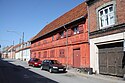 | Frisegade 43, 4800 Nykøbing F | 54°45′49.49″N 11°52′8.02″E / 54.7637472°N 11.8688944°E / 54.7637472; 11.8688944 | Half-timbered building from 1761[16] |
| Frisegade 45A, 4800 Nykøbing F | 54°45′49.2″N 11°52′8.36″E / 54.763667°N 11.8689889°E / 54.763667; 11.8689889 | Warehouse from 1845 to 1846 in the courtyard to the rear[17] | ||
| Gammel Kirstineberg | Kraghave Gaabensevej 95A, 4800 Nykøbing F | 54°47′43.74″N 11°52′9.13″E / 54.7954833°N 11.8692028°E / 54.7954833; 11.8692028 | Eastern side wing from the 18th century[18] | |
| Kraghave Gaabensevej 97, 4800 Nykøbing F | 54°47′44.95″N 11°52′7.91″E / 54.7958194°N 11.8688639°E / 54.7958194; 11.8688639 | Main building from the 18th centurye[19] | ||
| Generalens Lysthus |  | Tromnæs Alleen 10, 4800 Nykøbing F | 54°45′40.36″N 12°2′41.74″E / 54.7612111°N 12.0449278°E / 54.7612111; 12.0449278 | Thatched cottage in Tromnæs Forest from 1780 to 1790 by Andreas Kirkerup[20] |
| Guldborgvej 51 | Guldborgvej 51, 4990 Sakskøbing | [21] | ||
| Guldborgvej 51, 4990 Sakskøbing | [22] | |||
| Guldborgvej 51, 4990 Sakskøbing | [23] | |||
| Guldborgvej 51, 4990 Sakskøbing | [24] | |||
| Karleby Rectory | Tunderup Strandvej 1, 4800 Nykøbing F | 54°47′26.69″N 12°1′51.4″E / 54.7907472°N 12.030944°E / 54.7907472; 12.030944 | East wing of three-winged, half-timbered complex: Residential wing probably from 1766 to 1770[25] | |
| Tunderup Strandvej 1, 4800 Nykøbing F | 54°47′26.69″N 12°1′51.4″E / 54.7907472°N 12.030944°E / 54.7907472; 12.030944 | North wing of three-winged, half-timbered complex: Stables[26] | ||
| Tunderup Strandvej 1, 4800 Nykøbing F | 54°47′26.69″N 12°1′51.4″E / 54.7907472°N 12.030944°E / 54.7907472; 12.030944 | West wing of three-winged, half-timbered complex: Barn2[27] | ||
| Klosterfløjen (Præstebolig) |  | Kirkepladsen 3, 4800 Nykøbing F | 54°45′56.16″N 11°52′9.32″E / 54.7656000°N 11.8692556°E / 54.7656000; 11.8692556 | Late Gothic former west wing of the Franciscan monastery which has later been adapted[28] |
| Kringelborg |  | Kringelborg Alle 11, 4800 Nykøbing F | 54°45′30.22″N 11°54′10.65″E / 54.7583944°N 11.9029583°E / 54.7583944; 11.9029583 | Manor house from the late 18th century[29] |
| Langgade 16-18 |  | Langgade 16, 4800 Nykøbing F | 54°46′0.9″N 11°52′0.98″E / 54.766917°N 11.8669389°E / 54.766917; 11.8669389 | Two townhouses of which No. 16 dates from c. 1800 and No. 18 dates from 1580[30] |
| Nykøbing Abbey | Klosterstræde 1B, 4800 Nykøbing F | 54°45′54.16″N 11°52′9.56″E / 54.7650444°N 11.8693222°E / 54.7650444; 11.8693222 | Vester Kloster 1828[31] | |
| Klosterstræde 1B, 4800 Nykøbing F | 54°45′54.16″N 11°52′9.56″E / 54.7650444°N 11.8693222°E / 54.7650444; 11.8693222 | Half-timbered outbuilding[32] | ||
 | Klosterstræde 3, 4800 Nykøbing F | 54°45′53.69″N 11°52′11.42″E / 54.7649139°N 11.8698389°E / 54.7649139; 11.8698389 | Sygeklosteret: Building from 1895[33] | |
| Klosterstræde 5, 4800 Nykøbing F | 54°45′52.75″N 11°52′10.03″E / 54.7646528°N 11.8694528°E / 54.7646528; 11.8694528 | Forstanderbolig: One-storey residential building from 1828[34] | ||
| Klosterstræde 7, 4800 Nykøbing F | 54°45′51.22″N 11°52′11.17″E / 54.7642278°N 11.8697694°E / 54.7642278; 11.8697694 | Frederik VII""s Kloster: Building from 1862[35] | ||
| Klosterstræde 9, 4800 Nykøbing F | 54°45′50.11″N 11°52′12.1″E / 54.7639194°N 11.870028°E / 54.7639194; 11.870028 | Christian VIII's Kloster: Building from 1848[36] | ||
| Voldgade 8, 4800 Nykøbing F | 54°45′50.78″N 11°52′15.25″E / 54.7641056°N 11.8709028°E / 54.7641056; 11.8709028 | Christian IX""s Kloster: Building from 1876[37] | ||
| Nykøbing Castle: Former stables |  | Rosenvænget 12, 4800 Nykøbing F | 54°44′9.11″N 11°52′0.1″E / 54.7358639°N 11.866694°E / 54.7358639; 11.866694 | Former stables from 1635 by Hans van Steenwinckel the Younger[38] |
| Nykøbing Latin School | Vestergade 15, 4800 Nykøbing F | 54°46′7.33″N 11°51′56.51″E / 54.7687028°N 11.8656972°E / 54.7687028; 11.8656972 | Two-winged school building from 1786[39] | |
| Priorskov | Priorskov 11, 4800 Nykøbing F | 54°44′1.65″N 11°50′31.93″E / 54.7337917°N 11.8422028°E / 54.7337917; 11.8422028 | Granary from the 17th century[40] | |
| Ritmestergården |  | Frisegade 1, 4800 Nykøbing F | 54°45′57.16″N 11°52′2.69″E / 54.7658778°N 11.8674139°E / 54.7658778; 11.8674139 | Ikder house altered in c. 1800 with Renaissance-style wing from c. 1620 along Kirkestræde[41] |
| Slotsgade 22 | Slotsgade 22A, 4800 Nykøbing F | 54°44′9.11″N 11°52′0.1″E / 54.7358639°N 11.866694°E / 54.7358639; 11.866694 | Building from c. 1825[42] |
4840 Nørre Alslev
| Listing name | Image | Location | Coordinates | Summary |
|---|---|---|---|---|
| Gåbense Færgegård | Gåbense Strandvej 61, 4840 Nørre Alslev | 54°56′37.96″N 11°52′36.07″E / 54.9438778°N 11.8766861°E / 54.9438778; 11.8766861 | Three-winged ferry inn from the 18th to 19th century[43] | |
| Lundby Windmill | Lundbyvej 44, 4840 Nørre Alslev | 54°51′53.51″N 11°50′2.68″E / 54.8648639°N 11.8340778°E / 54.8648639; 11.8340778 | Windmill from 1856[44] | |
| Orehoved Lighthouse | Havnegade 18, 4840 Nørre Alslev | 54°57′36.44″N 11°51′6.11″E / 54.9601222°N 11.8516972°E / 54.9601222; 11.8516972 | Lighthouse from 1895 which was heightened in 1932[45] | |
| Vennerslund | Vennerslundsvej 15, 4840 Nørre Alslev | 54°51′21.61″N 11°48′8.84″E / 54.8560028°N 11.8024556°E / 54.8560028; 11.8024556 | Old main building from c. 1770[46] | |
| Vennerslundsvej 19, 4840 Nørre Alslev | 54°51′21.69″N 11°48′5.16″E / 54.8560250°N 11.8014333°E / 54.8560250; 11.8014333 | The new main building from 1845 by O.M. Glahn[47] | ||
| Vester Kippinge Rectory | Egensevej 49, 4840 Nørre Alslev | 54°54′33.91″N 11°46′22.22″E / 54.9094194°N 11.7728389°E / 54.9094194; 11.7728389 | Rectory from 1840[48] |
4850 Stubbekøbing
| Listing name | Image | Location | Coordinates | Summary |
|---|---|---|---|---|
| Grønsund Færgegård | Gl. Færgevej 6, 4850 Stubbekøbing | 54°53′9.01″N 12°7′9.59″E / 54.8858361°N 12.1193306°E / 54.8858361; 12.1193306 | Part of residential building from 1731 and later[49] | |
| Gl. Færgevej 6, 4850 Stubbekøbing | 54°53′9.01″N 12°7′9.59″E / 54.8858361°N 12.1193306°E / 54.8858361; 12.1193306 | Part of residential building from 1731 and later[50] | ||
| Gl. Færgevej 6, 4850 Stubbekøbing | 54°53′9.01″N 12°7′9.59″E / 54.8858361°N 12.1193306°E / 54.8858361; 12.1193306 | Stable for travelers from c. 1860[51] | ||
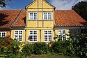
| Trojel House |  | Vestergade 16, 4850 Stubbekøbing | 54°53′25.95″N 12°2′25.94″E / 54.8905417°N 12.0405389°E / 54.8905417; 12.0405389 | Townhouse from the 18th century[52] |
| Vestergade 43 |  | Vestergade 43, 4850 Stubbekøbing | 54°48′2.09″N 12°2′17.69″E / 54.8005806°N 12.0382472°E / 54.8005806; 12.0382472 | House from 1847 probably built by af H. Thrane[53] |
4863 Eskilstrup
| Listing name | Image | Location | Coordinates | Summary |
|---|---|---|---|---|
| Torkilstrup Windmill |  | Torkilstrupvej 10A, 4863 Eskilstrup | 54°52′7.73″N 11°55′46.01″E / 54.8688139°N 11.9294472°E / 54.8688139; 11.9294472 | Stub mill from 1743[54] |
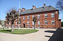
| Torkilstrup Rectory | Torkilstrupvej 14, 4863 Eskilstrup | 54°52′15.94″N 11°55′50.59″E / 54.8710944°N 11.9307194°E / 54.8710944; 11.9307194 | Three-winged rectory from 1761[55] |
4871 Horbelev
| Listing name | Image | Location | Coordinates | Summary |
|---|---|---|---|---|
| Bregninge School | Bregningevej 43, 4871 Horbelev | 54°48′52.06″N 12°4′27.4″E / 54.8144611°N 12.074278°E / 54.8144611; 12.074278 | School building from 1805[56] | |
| Bregningevej 43, 4871 Horbelev | 54°48′52.06″N 12°4′27.4″E / 54.8144611°N 12.074278°E / 54.8144611; 12.074278 | Outbuilding from 1805[57] | ||
| Moseby Rectory | Lyremosen 1, 4871 Horbelev | 54°50′22.12″N 12°6′16.96″E / 54.8394778°N 12.1047111°E / 54.8394778; 12.1047111 | Half-timbered, thatched west wing of four-winged complex[58] | |
| Hesnæsvej 56, 4871 Horbelev | 54°50′22.8″N 12°6′18.29″E / 54.839667°N 12.1050806°E / 54.839667; 12.1050806 | Residential east wing with two appendices[59] | ||
| Hesnæsvej 56, 4871 Horbelev | 54°50′22.8″N 12°6′18.29″E / 54.839667°N 12.1050806°E / 54.839667; 12.1050806 | Half-timbered north wing with stables2[60] | ||
| Hesnæsvej 56, 4871 Horbelev | 54°50′22.8″N 12°6′18.29″E / 54.839667°N 12.1050806°E / 54.839667; 12.1050806 | Half-timbered, thatched northwing with stables[61] |
4873 Væggerløse
| Listing name | Image | Location | Coordinates | Summary |
|---|---|---|---|---|
| Bøtø Nor Pumping Station |  | Møllesøvej 2, 4873 Væggerløse | 54°40′56.96″N 11°54′31.06″E / 54.6824889°N 11.9086278°E / 54.6824889; 11.9086278 | Pumping station from 1871[62] |
| Stouby Windmill | Stovbyvej 19A, 4873 Væggerløse | 54°42′54.83″N 11°53′57.67″E / 54.7152306°N 11.8993528°E / 54.7152306; 11.8993528 | Stub mill from c. 1750 which was moved to its present location in 1790[63] |
4874 Gedser
| Listing name | Image | Location | Coordinates | Summary |
|---|---|---|---|---|
| Bøtøgård Plantørbolig | Bøtøgårdsvej 23, 4874 Gedser | 54°36′43.24″N 11°57′44.93″E / 54.6120111°N 11.9624806°E / 54.6120111; 11.9624806 | House from c. 1880[64] | |
| Gjedsergaard | Gedsergaard 1, 4874 Gedser | 54°38′53.91″N 11°52′56.83″E / 54.6483083°N 11.8824528°E / 54.6483083; 11.8824528 | Main building from 1767 with extension from c. 1800[65] | |
| Gedsergaard 2, 4874 Gedser | 54°48′56.83″N 11°52′55.62″E / 54.8157861°N 11.8821167°E / 54.8157861; 11.8821167 | Kavalerfløjen: Staff wing from 1767[66] |
4880 Nysted
| Listing name | Image | Location | Coordinates | Summary |
|---|---|---|---|---|
| Aalholm |  | Ålholm Parkvej 4, 4880 Nysted | 54°39′52.52″N 11°43′23.36″E / 54.6645889°N 11.7231556°E / 54.6645889; 11.7231556 | Northeastern tower and west wall from the 14th century and eastern wing from 1581 which were all adapted in 1889 by Hans Jørgen Holm[67] |
| Ålholm Parkvej 4, 4880 Nysted | 54°39′52.52″N 11°43′23.36″E / 54.6645889°N 11.7231556°E / 54.6645889; 11.7231556 | Bjørnehuset[68] | ||
| Adelgade 11 and 17: Clausen's Warehouse and Bønnelyche's Warehouse | 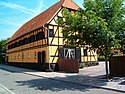 | Adelgade 11, 4880 Nysted | 54°40′9.58″N 11°43′43.61″E / 54.6693278°N 11.7287806°E / 54.6693278; 11.7287806 | Clausen's Warehouse: Half-timbered ware house from 1807[69] |
 | Adelgade 18B, 4880 Nysted | 54°40′7.42″N 11°43′45.34″E / 54.6687278°N 11.7292611°E / 54.6687278; 11.7292611 | Bønnelyche's Warehouse: Warehouse from 1851[70] | |
| Adelgade 23 | Adelgade 23, 4880 Nysted | 54°40′5.72″N 11°43′43.41″E / 54.6682556°N 11.7287250°E / 54.6682556; 11.7287250 | Townhouse from 1870[71] | |
| Adelgade 23, 4880 Nysted | 54°40′5.72″N 11°43′43.41″E / 54.6682556°N 11.7287250°E / 54.6682556; 11.7287250 | Parallel building in the courtyard to the west from 1872[72] | ||
| Adelgade 28 B | 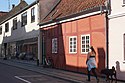 | Adelgade 28B, 4880 Nysted | 54°40′5.74″N 11°43′42.68″E / 54.6682611°N 11.7285222°E / 54.6682611; 11.7285222 | Townhouse from the first half of the 17th century[73] |
| Adelgade 40 | Adelgade 42, 4880 Nysted | 54°40′3.13″N 11°43′42.48″E / 54.6675361°N 11.7284667°E / 54.6675361; 11.7284667 | Warehouse originally dating from some time between 1781 and 1791 but altered in 1928 [74] | |
| Adelgade 80: Emil Aarestrup House | 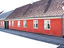 | Adelgade 80, 4880 Nysted | 54°39′55.26″N 11°43′50.45″E / 54.6653500°N 11.7306806°E / 54.6653500; 11.7306806 | House from the 18th century which was adapted in c. 1800 with southern side wing from c. 1800 and northern side wing from before 1791[75] |
| Bramsløkke |  | Bramsløkkevej 7A, 4880 Nysted | 54°43′46.54″N 11°39′37.51″E / 54.7295944°N 11.6604194°E / 54.7295944; 11.6604194 | Manor house from c. 1700[76] |
| Fiskergade 12 | Fiskergade 12, 4880 Nysted | 54°39′46.75″N 11°43′56.38″E / 54.6629861°N 11.7323278°E / 54.6629861; 11.7323278 | Townhouse from before 1761[77] | |
| Fiskergade 12, 4880 Nysted | 54°39′46.75″N 11°43′56.38″E / 54.6629861°N 11.7323278°E / 54.6629861; 11.7323278 | Side wing from before 1761[78] | ||
| Gammel Torv 2 | Gl Torv 2, 4880 Nysted | 54°39′51.47″N 11°43′55.76″E / 54.6642972°N 11.7321556°E / 54.6642972; 11.7321556 | Townhouse from 1831 which was adapted in 1922 by Johannes Holck[79] | |
| Gl Torv 2, 4880 Nysted | 54°39′51.47″N 11°43′55.76″E / 54.6642972°N 11.7321556°E / 54.6642972; 11.7321556 | Rear and side wing[80] | ||
| Gammel Torv 3-7 | Gl Torv 3, 4880 Nysted | 54°39′51.92″N 11°43′57.08″E / 54.6644222°N 11.7325222°E / 54.6644222; 11.7325222 | No. 3: Building from 1831[81] | |
 | Gl Torv 3, 4880 Nysted | 54°39′51.92″N 11°43′57.08″E / 54.6644222°N 11.7325222°E / 54.6644222; 11.7325222 | No. 5: 1846[82] | |
 | Gl Torv 3, 4880 Nysted | 54°39′51.92″N 11°43′57.08″E / 54.6644222°N 11.7325222°E / 54.6644222; 11.7325222 | No. 7: Building from the 17th century[83] | |
| Gl Torv 3, 4880 Nysted | 54°39′51.92″N 11°43′57.08″E / 54.6644222°N 11.7325222°E / 54.6644222; 11.7325222 | Building in the courtyard from 1847[84] | ||
| Nysted Smokehouse | Strandvejen 20, 4880 Nysted | 54°39′41.16″N 11°43′53.21″E / 54.6614333°N 11.7314472°E / 54.6614333; 11.7314472 | Smokehouse from 1871[85] | |
| Nysted Water Tower | 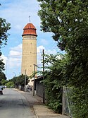 | Ny Østergade 11, 4880 Nysted | 54°40′12.1″N 11°43′47.59″E / 54.670028°N 11.7298861°E / 54.670028; 11.7298861 | Water tower from 1912 to 1913 by the architect Alf. Jørgensen and the engineer Georg Jochimsen[86] |
| Østergade 9A: Borgerstiftelsen |  | Østergade 9A, 4880 Nysted | 54°40′0.52″N 11°43′53.12″E / 54.6668111°N 11.7314222°E / 54.6668111; 11.7314222 | Building fronting the street from 1877 to 1878[87] |
| Østergade 9A, 4880 Nysted | 54°40′0.52″N 11°43′53.12″E / 54.6668111°N 11.7314222°E / 54.6668111; 11.7314222 | Rear wing from 1877 to 1878[88] | ||
| Østergade 13 | Østergade 13, 4880 Nysted | 54°39′58.8″N 11°43′54.77″E / 54.666333°N 11.7318806°E / 54.666333; 11.7318806 | Townhouse from 1876[89] |
4990 Sakskøbing
| Listing name | Image | Location | Coordinates | Summary |
|---|---|---|---|---|
| Berritzgaard | 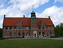 | Kogangen 8, 4990 Sakskøbing | 54°49′18.25″N 11°39′56.33″E / 54.8217361°N 11.6656472°E / 54.8217361; 11.6656472 | Manor house from 1586 possibly designed by Hans van Steenwinckel the Elder[90] |
| Hotel Saxkjøbing | 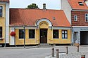 | Torvet 9A, 4990 Sakskøbing | 54°47′57.92″N 11°38′4.14″E / 54.7994222°N 11.6344833°E / 54.7994222; 11.6344833 | Building on the square, former theatre building and halkf-timbered wing on Juniorsgade from c. 1800[91] |
 | Torvet 9A, 4990 Sakskøbing | 54°47′57.92″N 11°38′4.14″E / 54.7994222°N 11.6344833°E / 54.7994222; 11.6344833 | Building on the square, former theatre building and halkf-timbered wing on Juniorsgade from c. 1800[92] | |
| Juniors Stiftelse, | Juniorsgade 6, 4990 Sakskøbing | 54°47′57.79″N 11°38′1.38″E / 54.7993861°N 11.6337167°E / 54.7993861; 11.6337167 | 22-bay, one-storey building with timber framing from 1802[93] | |
| Krenkerup |  | Krenkerupvej 27, 4990 Sakskøbing | 54°46′38.16″N 11°43′43.41″E / 54.7772667°N 11.7287250°E / 54.7772667; 11.7287250 | Main building from c. 1500-1631[94] |
| Krenkerupvej 27, 4990 Sakskøbing | 54°40′5.72″N 11°40′11.5″E / 54.6682556°N 11.669861°E / 54.6682556; 11.669861 | Stables from the 17th century and later[95] | ||
| Orebygaard | Orebygaard 5, 4990 Sakskøbing | 54°49′46.25″N 11°35′47.54″E / 54.8295139°N 11.5965389°E / 54.8295139; 11.5965389 | Manor house from the 1870s by Ove Petersen with older core[96] | |
| Wichmann House | Brogade 2A, 4990 Sakskøbing | 54°53′24.42″N 11°38′9.56″E / 54.8901167°N 11.6359889°E / 54.8901167; 11.6359889 | House from c.1770-80[97] |
4891 Toreby L
| Listing name | Image | Location | Coordinates | Summary |
|---|---|---|---|---|
| Fuglsang Manor | 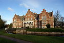 | Nystedvej 73, 4891 Toreby L | 54°43′18.99″N 11°47′51.72″E / 54.7219417°N 11.7977000°E / 54.7219417; 11.7977000 | Main building from 1868 to 1869 by J.G. Zinn[98] |
 | Nystedvej 73, 4891 Toreby L | 54°43′18.99″N 11°47′51.72″E / 54.7219417°N 11.7977000°E / 54.7219417; 11.7977000 | pavilion[99] | |
| Nystedvej 73C, 4891 Toreby L | 54°43′26.26″N 11°47′54.52″E / 54.7239611°N 11.7984778°E / 54.7239611; 11.7984778 | Warehouse from 1845 to 1846 in the courtyard to the rear[100] |
4930 Maribo
| Listing name | Image | Location | Coordinates | Summary |
|---|---|---|---|---|
| Engestofte |  | Engestoftevej 95, 4930 Maribo | 54°45′45.58″N 11°33′43.03″E / 54.7626611°N 11.5619528°E / 54.7626611; 11.5619528 | Main building from 1805 to 1807[101] |
Delisted buildings
| Listing name | Image | Location | Coordinates | Summary |
|---|---|---|---|---|
| Ønslev Præstegårds Forpagterbolig | Lundbyvej 12, 4863 Eskilstrup | 54°51′0.84″N 11°51′4.73″E / 54.8502333°N 11.8513139°E / 54.8502333; 11.8513139 | [102] |
References
- ^ "FBB - sag".
- ^ "FBB - sag".
- ^ "FBB - sag".
- ^ "FBB - sag".
- ^ "FBB - sag".
- ^ "FBB - sag".
- ^ "FBB - sag".
- ^ "FBB - sag".
- ^ "FBB - sag".
- ^ "FBB - sag".
- ^ "FBB - sag".
- ^ "FBB - sag".
- ^ "FBB - sag".
- ^ "FBB - sag".
- ^ "FBB - sag".
- ^ "FBB - sag".
- ^ "FBB - sag".
- ^ "FBB - sag".
- ^ "FBB - sag".
- ^ "FBB - sag".
- ^ "FBB - sag".
- ^ "FBB - sag".
- ^ "FBB - sag".
- ^ "FBB - sag".
- ^ "FBB - sag".
- ^ "FBB - sag".
- ^ "FBB - sag".
- ^ "FBB - sag".
- ^ "FBB - sag".
- ^ "FBB - sag".
- ^ "FBB - sag".
- ^ "FBB - sag".
- ^ "FBB - sag".
- ^ "FBB - sag".
- ^ "FBB - sag".
- ^ "FBB - sag".
- ^ "FBB - sag".
- ^ "FBB - sag".
- ^ "FBB - sag".
- ^ "FBB - sag".
- ^ "FBB - sag".
- ^ "FBB - sag".
- ^ "FBB - sag".
- ^ "FBB - sag".
- ^ "FBB - sag".
- ^ "FBB - sag".
- ^ "FBB - sag".
- ^ "FBB - sag".
- ^ "FBB - sag".
- ^ "FBB - sag".
- ^ "FBB - sag".
- ^ "FBB - sag".
- ^ "FBB - sag".
- ^ "FBB - sag".
- ^ "FBB - sag".
- ^ "FBB - sag".
- ^ "FBB - sag".
- ^ "FBB - sag".
- ^ "FBB - sag".
- ^ "FBB - sag".
- ^ "FBB - sag".
- ^ "FBB - sag".
- ^ "FBB - sag".
- ^ "FBB - sag".
- ^ "FBB - sag".
- ^ "FBB - sag".
- ^ "FBB - sag".
- ^ "FBB - sag".
- ^ "FBB - sag".
- ^ "FBB - sag".
- ^ "FBB - sag".
- ^ "FBB - sag".
- ^ "FBB - sag".
- ^ "FBB - sag".
- ^ "FBB - sag".
- ^ "FBB - sag".
- ^ "FBB - sag".
- ^ "FBB - sag".
- ^ "FBB - sag".
- ^ "FBB - sag".
- ^ "FBB - sag".
- ^ "FBB - sag".
- ^ "FBB - sag".
- ^ "FBB - sag".
- ^ "FBB - sag".
- ^ "FBB - sag".
- ^ "FBB - sag".
- ^ "FBB - sag".
- ^ "FBB - sag".
- ^ "FBB - sag".
- ^ "FBB - sag".
- ^ "FBB - sag".
- ^ "FBB - sag".
- ^ "FBB - sag".
- ^ "FBB - sag".
- ^ "FBB - sag".
- ^ "FBB - sag".
- ^ "FBB - sag".
- ^ "FBB - sag".
- ^ "FBB - sag".
- ^ "FBB - sag".
- ^ "FBB - sag".
External links
Wikimedia Commons has media related to Listed buildings in Guldborgsund Kommune.
- Danish Agency of Culture
- v
- t
- e
Listed buildings in Denmark by municipality
- Albertslund
- Allerød
- Assens
- Ballerup
- Billund
- Bornholm
- Brøndby
- Brønderslev
- Copenhagen
- Dragør
- Egedal
- Esbjerg
- Faaborg-Midtfyn
- Fanø
- Favrskov
- Faxe
- Fredensborg
- Fredericia
- Frederiksberg
- Frederikshavn
- Frederikssund
- Furesø
- Gentofte
- Gladsaxe
- Glostrup
- Greve
- Gribskov
- Guldborgsund
- Haderslev
- Halsnæs
- Hedensted
- Helsingør
- Herlev
- Herning
- Hillerød
- Hjørring
- Høje-Taastrup
- Hørsholm
- Holbæk
- Holstebro
- Horsens
- Hvidovre
- Ikast-Brande
- Ishøj
- Jammerbugt
- Kalundborg
- Kerteminde
- Køge
- Kolding
- Læsø
- Langeland
- Lejre
- Lemvig
- Lolland
- Lyngby-Taarbæk
- Mariagerfjord
- Middelfart
- Morsø
- Næstved
- Norddjurs
- Nordfyn
- Nyborg
- Odder
- Odense
- Odsherred
- Randers
- Rebild
- Ringsted
- Ringkøbing-Skjern
- Rødovre
- Roskilde
- Rudersdal
- Samsø
- Silkeborg
- Skanderborg
- Skive
- Slagelse
- Solrød
- Sønderborg
- Sorø
- Stevns
- Struer
- Svendborg
- Syddjurs
- Tårnby
- Thisted
- Tønder
- Vallensbæk
- Varde
- Vejen
- Vejle
- Vesthimmerland
- Vibrg
- Vordingborg
- Ærø
- Aabenraa
- Aalborg
- Aarhus


