Lužce
Municipality in Central Bohemian, Czech Republic
49°59′3″N 14°11′48″E / 49.98417°N 14.19667°E / 49.98417; 14.19667 Czech Republic
 (2023-01-01)[1]
267 18
Lužce is a municipality and village in Beroun District in the Central Bohemian Region of the Czech Republic. It has about 100 inhabitants.
Geography
Lužce is located about 9 kilometres (6 mi) east of Beroun and 15 km (9 mi) west of Prague. It lies in the Hořovice Uplands. The highest point is at 428 m (1,404 ft) above sea level. There is a set of small fishponds, supplied by the stream Karlický potok.
Demographics
| Year | Pop. | ±% |
|---|---|---|
| 1869 | 191 | — |
| 1880 | 203 | +6.3% |
| 1890 | 223 | +9.9% |
| 1900 | 212 | −4.9% |
| 1910 | 225 | +6.1% |
| 1921 | 226 | +0.4% |
| 1930 | 252 | +11.5% |
| 1950 | 129 | −48.8% |
| 1961 | 147 | +14.0% |
| 1970 | 132 | −10.2% |
| 1980 | 112 | −15.2% |
| 1991 | 91 | −18.8% |
| 2001 | 96 | +5.5% |
| 2011 | 122 | +27.1% |
| 2021 | 155 | +27.0% |
| Source: Censuses[2][3] | ||
Gallery
-
 Municipal office
 -
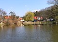 Lower pond


References
- ^ "Population of Municipalities – 1 January 2023". Czech Statistical Office. 2023-05-23.
- ^ "Historický lexikon obcí České republiky 1869–2011 – Okres Beroun" (in Czech). Czech Statistical Office. 2015-12-21. pp. 7–8.
- ^ "Population Census 2021: Population by sex". Public Database. Czech Statistical Office. 2021-03-27.
External links
Wikimedia Commons has media related to Lužce.
- Official website
- v
- t
- e
Towns, market towns and villages of Beroun District
- Bavoryně
- Beroun
- Běštín
- Broumy
- Březová
- Bubovice
- Bykoš
- Bzová
- Cerhovice
- Chaloupky
- Chlustina
- Chodouň
- Chrustenice
- Chyňava
- Drozdov
- Felbabka
- Hlásná Třebaň
- Hořovice
- Hostomice
- Hředle
- Hudlice
- Hvozdec
- Hýskov
- Jivina
- Karlštejn
- Komárov
- Koněprusy
- Korno
- Kotopeky
- Králův Dvůr
- Kublov
- Lážovice
- Lhotka
- Libomyšl
- Liteň
- Lochovice
- Loděnice
- Lužce
- Malá Víska
- Málkov
- Měňany
- Mezouň
- Mořina
- Mořinka
- Nenačovice
- Nesvačily
- Neumětely
- Nižbor
- Nový Jáchymov
- Olešná
- Osek
- Osov
- Otmíče
- Otročiněves
- Podbrdy
- Podluhy
- Praskolesy
- Rpety
- Skřipel
- Skuhrov
- Srbsko
- Stašov
- Suchomasty
- Svatá
- Svatý Jan pod Skalou
- Svinaře
- Tetín
- Tlustice
- Tmaň
- Točník
- Trubín
- Trubská
- Újezd
- Velký Chlumec
- Vinařice
- Vižina
- Vráž
- Všeradice
- Vysoký Újezd
- Zadní Třebaň
- Zaječov
- Záluží
- Zdice
- Žebrák
- Železná
| Authority control databases: National |
|
|---|
This Beroun District location article is a stub. You can help Wikipedia by expanding it. |
- v
- t
- e


