Mýrdalsjökull
Glacier in Iceland

Mýrdalsjökull (pronounced [ˈmirˌtalsˌjœːkʏtl̥] ⓘ, Icelandic for "(the) mire dale glacier" or "(the) mire valley glacier") is an ice cap in the south of Iceland. It is to the north of Vík í Mýrdal and to the east of the smaller ice cap Eyjafjallajökull. Between these two glaciers is Fimmvörðuháls pass. Its peak reaches 1,493 m (4,898 ft) in height and in the year 1980 it covered an area of approximately 595 km2 (230 sq mi).[1] In 2016 the covered area of Mýrdalsjökull was believed to be 540 km2 (210 sq mi).[2]
The icecap of the glacier covers an active volcano called Katla. The caldera of the volcano has a diameter of 10 km (6 mi) and the volcano erupts usually every 40–80 years. The last eruption took place in 1918. Scientists are actively monitoring the volcano, particularly after the eruption of nearby Eyjafjallajökull began in April 2010. Since the year 930, 16 eruptions have been documented.
The Eldgjá, a volcanic eruption fissure about 30 km (19 mi) long, which erupted in the year 939, is part of the same volcanic system.[3]
Before the Hringvegur (the main ring road round the island) was built, people feared traversing the plains in front of the volcano because of the frequent jökulhlaups (glacial floods) and the deep rivers to be crossed, although the road is still vulnerable to major events. Especially dangerous was the glacial flood after the eruption of 1918 when the coastline was extended by 5 km (3.1 mi) by laharic flood deposits.
Mýrdalsjökull is an exceedingly wet location, with models suggesting it receives more than 10 metres of precipitation annually.[4]
-
 Mýrdalsjökull ice cap concealing Katla volcano
 -
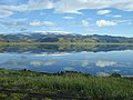
 Mýrdalsjökull
 -
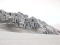 An "ice castle" formation on Mýrdalsjökull
 -
 Mýrdalsjökull glacier covered volcanic ash
 -
 Outlet glacier Sólheimajökull


See also
- Geography of Iceland
- Glaciers of Iceland
- Iceland plume
- List of lakes in Iceland
- List of islands of Iceland
- List of volcanoes in Iceland
- List of rivers of Iceland
- Volcanism of Iceland
- Waterfalls of Iceland
- List of glaciers
References
- ^ Humlum, Ole (1985). "Changes in Texture and Fabric of Particles in Glacial Traction with Distance from Source, Mỳrdalsjökull, Iceland". Journal of Glaciology. 31 (108): 150–156. doi:10.1017/S0022143000006390. ISSN 0022-1430.
- ^ Björnsson, Helgi (2017), Björnsson, Helgi (ed.), "Glaciers of Southern Iceland", The Glaciers of Iceland: A Historical, Cultural and Scientific Overview, Paris: Atlantis Press, pp. 211–273, doi:10.2991/978-94-6239-207-6_5, ISBN 978-94-6239-207-6, retrieved 2024-04-26
- ^ Moreland, William Michael; Thordarson, Thor; Houghton, Bruce F.; Larsen, Gudrún (28 August 2019). "Driving mechanisms of subaerial and subglacial explosive episodes during the 10th century Eldgjá fissure eruption, southern Iceland". Volcanica. 2 (2): 129–150. doi:10.30909/vol.02.02.129150. ISSN 2610-3540. S2CID 202923626.
- ^ "Late Holocene Glacial History of Sólheimajökull, Southern Iceland" (PDF). Archived from the original (PDF) on 2014-03-20.
External links
Wikimedia Commons has media related to Katla.
- http://www.nimbus.it/glaciorisk/Glacier_view.asp?IdGlacier=3965&Vista=paese&Paese=Iceland&IdTipoRischio= (Details of all known Glacier Runs from Mýrdalsjökull)
- http://isafold.de/strutstigur02/img_jokull.htm (Photo of Mýrdalsjökull)
- https://web.archive.org/web/20040504154433/http://volcano.und.edu/vwdocs/volc_images/europe_west_asia/eldgja.html (Volcanism)
- Katla: eruption preparedness for tourists
- v
- t
- e

| Authority control databases |
|
|---|
63°40′N 19°06′W / 63.667°N 19.100°W / 63.667; -19.100


