Maloja Pass
High alpine pass in Swiss canton of Graubünden


Maloja Pass
Location in Switzerland
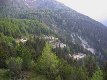
Maloja Pass (Italian: Passo del Maloja, German: Malojapass) (1815m a.s.l.) is a high mountain pass in the Swiss Alps in the canton of Graubünden, linking the Engadine with the Val Bregaglia, still in Switzerland and Chiavenna in Italy. It marks the divide between the Danube and Po watersheds. Lägh da Bitabergh is near the pass.[1]
The road from Chiavenna to Silvaplana with distances and elevation:
- 0 km Chiavenna 333 m
- 10 km Castasegna (Italian-Swiss border) 696 m
- 13 km Promontogno 802 m
- 16 km Stampa 994 m
- 18 km Borgonovo 1029 m
- 19 km Vicosoprano 1065 m
- 27 km Casaccia 1458 m
- 32 km Maloja Pass 1815 m
- 33 km Maloja 1809 m
- 40 km Sils im Engadin/Segl 1798 m
- 44 km Silvaplana 1802 m
The Maloja Pass is open in winter. However, after heavy snowfalls the road may be closed for a couple of hours or for an entire day. Even if open, the road might be covered with snow making snow/winter tires, or chains, a necessity.
The lowest point of the col, and the lowest point on the watershed between the basins of the Inn and the Po in Switzerland lies at an altitude of 1,812 m.
See also
- Engadine Line, a geological structure
- List of highest paved roads in Switzerland (roads above 1,850 m)
- List of highest road passes in Switzerland
- List of mountain passes in Switzerland
- Maloja Wind
References
- ^ "Malojapass". www.engadin.ch.
External links
- Cyclists descend the pass on the seventh stage of the 92nd Giro d'Italia
| Authority control databases |
|
|---|


