Marsham, Norfolk
Human settlement in England
- Marsham
- Broadland
- Norfolk
- East
Marsham is a village and civil parish in the English county of Norfolk, about 10 miles (16 km) north of Norwich. It covers an area of 7.40 km2 (2.86 sq mi) and had a population of 674 in 282 households at the 2001 census.[1]
For local government purposes, it falls within the district of Broadland. Marsham has its own Parish Council, Marsham Parish Council.[2]
History
The Imperial Gazetteer of England and Wales (1870–1872) described Marsham thus:
MARSHAM, a village and a parish in Aylsham district, Norfolk. The village stands near the river Bure, 2 miles S of Aylsham, and 11 N of Norwich r. station; and gives the title of Viscount to Earl Romney. The parish comprises 1,819 acres. Real property, £2,314. Pop., 622. Houses, 148. The property is subdivided. Bolwick Hall is the seat of J. H. Warnes, Esq. The ancestors of Earl Romney resided in the parish in the 12th century. The living is a rectory in the diocese of Norwich. Value, £281. Patrons, Miss C. Blake and the Rev. E. T. Yates. The church consists of nave and chancel, with a tower; and contains an ancient screen, a carved font, and monuments of the Norrises and others. There are a Primitive Methodist chapel, and charities £18.[3]
Gallery
-
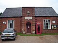 The Mutual Improvement Institution is a Grade II listed building dating back to 1857.
 -
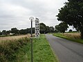 The village sign was erected in 1953 to commemorate the coronation of Queen Elizabeth II.
 -
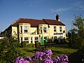 The Plough Inn Marsham
 -
 The village sign depicts the peewit bird


References
- ^ Census population and household counts for unparished urban areas and all parishes. Office for National Statistics & Norfolk County Council (2001). Retrieved 20 June 2009.
- ^ "Marsham Parish Council".
- ^ Wilson, John Marius, Imperial Gazetteer of England and Wales (1870-1872), extract for Marsham online at visionofbritain.org.uk, accessed 24 January 2009
Wikimedia Commons has media related to Marsham.
- v
- t
- e
- Acle
- Alderford
- Attlebridge
- Aylsham
- Beeston St Andrew
- Beighton
- Belaugh
- Blickling
- Blofield
- Booton
- Brampton
- Brandiston
- Brundall
- Burgh and Tuttington
- Buxton with Lammas
- Cantley, Limpenhoe and Southwood
- Cawston
- Coltishall
- Crostwick
- Drayton
- Felthorpe
- Foulsham
- Freethorpe
- Frettenham
- Great and Little Plumstead
- Great Witchingham
- Guestwick
- Hainford
- Halvergate
- Haveringland
- Hellesdon
- Hemblington
- Hevingham
- Heydon
- Honingham
- Horsford
- Horsham St Faith and Newton St Faith
- Horstead with Stanninghall
- Lingwood and Burlingham
- Little Witchingham
- Marsham
- Morton on the Hill
- Old Catton
- Oulton
- Postwick with Witton
- Rackheath
- Reedham
- Reepham
- Ringland
- Salhouse
- Salle
- South Walsham
- Spixworth
- Sprowston
- Stratton Strawless
- Strumpshaw
- Swannington
- Taverham
- Themelthorpe
- Thorpe St Andrew
- Upton with Fishley
- Weston Longville
- Woodbastwick
- Wood Dalling
- Wroxham
- See also
- Breckland
- Great Yarmouth
- King's Lynn and West Norfolk
- North Norfolk
- South Norfolk
 | This Norfolk location article is a stub. You can help Wikipedia by expanding it. |
- v
- t
- e


