Meroo National Park
Protected area in New South Wales, Australia
35°25′15″S 150°24′15″E / 35.42083°S 150.40417°E / -35.42083; 150.40417New South Wales
Meroo National Park is a national park in on South Coast of New South Wales, Australia.
History
Meroo has only recently been designated as a National Park. Previously it was a state forest which contained an unregulated camp ground with beautiful beaches and bushland. The area was badly damaged over ten years ago by bushfires. Because of this damage and its constant use by holiday goers the National Park lands authority decided to create a National Park on this State Forest land in an attempt to help regenerate the bushland.
Description
As well as the beaches there are tidal rockpools and a rocky island that can be reached at low tide. Many sea creatures can be found such as crabs, star fish, small fish and sea urchins. Since its creation as a National Park new rules and regulations have been brought in to increase care of the natural bushland and native fauna. Fenced off areas around the headlands to stop erosion have been created and areas for camping have been reduced. This has helped to increase the natural bush regenerate from the devastating fires. The park's wildlife appears to be increasing in numbers with wallabies and possums being seen regularly. The sound of native birds can be heard again too. The park forms part of the Ulladulla to Merimbula Important Bird Area, identified as such by BirdLife International because of its importance for swift parrots.[1]
Meroo is home to 12 endangered wildlife species, including the nationally endangered green and golden bell frog.[2]
The average elevation of the terrain is 55 metres above sea level.[3]
-
 Beach directly south of Termeil Point
 -
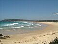
 View north from Termeil Point towards Tabourie Lake
 -
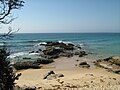 Rocks at Termeil Point, Meroo National Park


See also
- Protected areas of New South Wales (Australia)
References
- ^ BirdLife International. (2012). Important Bird Areas factsheet: Ulladulla to Merimbula. Downloaded from http://www.birdlife.org on 2012-01-02.
- ^ "Meroo National Park | Learn more". NSW National Parks. Retrieved 28 October 2021.
- ^ "Meroo National Park topographic map, elevation, relief". topographic-map.com. Retrieved 28 October 2021.
- v
- t
- e
National parks of New South Wales, Australia
- Abercrombie
- Breelong
- Capertee
- Conimbla
- Coolah Tops
- Drillwarrina
- Gardens of Stone
- Garrawilla
- Goobang
- Goulburn
- Kanangra-Boyd
- Lachlan Valley
- Marrangaroo
- Nangar
- Popran
- Turon
- Warrumbungle
- Weddin Mountains
- Wollemi
- Brindingabba
- Culgoa
- Gundabooka
- Kalyarr
- Kemendok
- Kinchega
- Koonaburra
- Mallee Cliffs
- Mungo
- Mutawintji
- Narriearra Caryapundy Swamp
- Paroo-Darling
- Sturt
- Toorale
- Yanga
- Barakee
- Barrington Tops
- Belford
- Ben Halls Gap
- Biriwal Bulga
- Booti Booti
- Bouddi
- Brisbane Water
- Coolah Tops
- Coorabakh
- Crawney Pass
- Crowdy Bay
- Dharug
- Gir-um-bit
- Goulburn River
- Gin-Doo-Ee
- Hunter Wetlands
- Karuah
- Middle Brother
- Mount Royal
- Myall Lakes
- Saltwater
- Scone Mountain
- Tapin Tops
- Tilligerry
- Towarri
- Tomaree
- Wallarah
- Wallingat
- Watagans
- Werakata
- Woko
- Wollemi
- Wyrrabalong
- Yengo
- Bald Rock
- Barool
- Basket Swamp
- Boonoo Boonoo
- Ben Halls Gap
- Burral Yurrul
- Butterleaf
- Capoompeta
- Carrai
- Cascade
- Cataract
- Cathedral Rock
- Coolah Tops
- Cottan-Bimbang
- Couradda
- Crawney Pass
- Cunnawarra
- Dowe
- Gibraltar Range
- Guy Fawkes River
- Indwarra
- Kings Plain
- Koreelah
- Kwiambal
- Maryland
- Mount Clunie
- Mount Kaputar
- Mount Nothofagus
- Mummel Gulf
- New England
- Nowendoc
- Nullamanna
- Nymboida
- Oxley Wild Rivers
- Single
- Timbarra
- Tooloom
- Towarri
- Warra
- Warrabah
- Washpool
- Watsons Creek
- Werrikimbe
- Arakwal
- Bago Bluff
- Bellinger River
- Bindarri
- Biriwal Bulga
- Bongil Bongil
- Border Ranges
- Broadwater
- Bundjalung
- Bungawalbin
- Carrai
- Chaelundi
- Cottan-Bimbang
- Crowdy Bay
- Dooragan
- Dorrigo
- Dunggir
- Fortis Creek
- Gibraltar Range
- Goonengerry
- Guy Fawkes River
- Hat Head
- Junuy Juluum
- Kumbatine
- Limeburners Creek
- Mallanganee
- Maria
- Mebbin
- Middle Brother
- Mooball
- Mount Jerusalem
- Mount Nothofagus
- Mount Pikapene
- New England
- Nightcap
- Nymboi-Binderay
- Nymboida
- Ramornie
- Richmond Range
- Sea Acres
- Toonumber
- Ulidarra
- Washpool
- Werrikimbe
- Willi Willi
- Wollumbin
- Yabbra
- Yarrahapinni Wetlands
- Yarriabini
- Yuraygir
- Benambra
- Brindabella
- Cocoparra
- Jimberoo
- Jindalee
- Kalyarr
- Kosciuszko
- Lachlan Valley
- Livingstone
- Minjary
- Murray Valley
- Murrumbidgee Valley
- Oolambeyan
- Willandra
- Woomargama
- Yanga
- Abercrombie
- Bangadilly
- Beowa
- Biamanga
- Blue Mountains
- Bournda
- Brindabella
- Budawang
- Budderoo
- Clyde River
- Deua
- Eurobodalla
- Gourock
- Gulaga
- Kooraban
- Kosciuszko
- Mares Forest
- Macquarie Pass
- Mimosa Rocks
- Monga
- Morton
- Mount Imlay
- Murramarang
- Nattai
- South East Forests
- Tallaganda
- Tarlo River
- Wadbilliga
- Yanununbeyan
 | This New South Wales protected areas related article is a stub. You can help Wikipedia by expanding it. |
- v
- t
- e


