Moss Bank railway station
Former railway station in England
53°28′27″N 2°44′24″W / 53.474130°N 2.739972°W / 53.474130; -2.739972
St Helens & Runcorn Gap Railway | |||||||||||||||||||||||||||||||||||||||||||||||||||||||||||||||||||||||||||||||||||||||||||||||||||||||||||||||||||||||||||||||||||||||||||||||||||||||||||||||||||||||||||||||||||||||||||||||||||||||||||||||||||||||||||||||||||||||||||||||||||||||||||||||||||||||||||||||||||||||||||||||||||||||||||||||||||||||||||||||||||||||||||||||||||||||||||||||||||||||||||||||||||||||||||||||||||||||||||||||||||||||||||||||||||||||||||||||||||||||||||||||||||||||||||||||||||||||||||||||||||||||||||||||||||||||||||||||||||||||||||||||||||
|---|---|---|---|---|---|---|---|---|---|---|---|---|---|---|---|---|---|---|---|---|---|---|---|---|---|---|---|---|---|---|---|---|---|---|---|---|---|---|---|---|---|---|---|---|---|---|---|---|---|---|---|---|---|---|---|---|---|---|---|---|---|---|---|---|---|---|---|---|---|---|---|---|---|---|---|---|---|---|---|---|---|---|---|---|---|---|---|---|---|---|---|---|---|---|---|---|---|---|---|---|---|---|---|---|---|---|---|---|---|---|---|---|---|---|---|---|---|---|---|---|---|---|---|---|---|---|---|---|---|---|---|---|---|---|---|---|---|---|---|---|---|---|---|---|---|---|---|---|---|---|---|---|---|---|---|---|---|---|---|---|---|---|---|---|---|---|---|---|---|---|---|---|---|---|---|---|---|---|---|---|---|---|---|---|---|---|---|---|---|---|---|---|---|---|---|---|---|---|---|---|---|---|---|---|---|---|---|---|---|---|---|---|---|---|---|---|---|---|---|---|---|---|---|---|---|---|---|---|---|---|---|---|---|---|---|---|---|---|---|---|---|---|---|---|---|---|---|---|---|---|---|---|---|---|---|---|---|---|---|---|---|---|---|---|---|---|---|---|---|---|---|---|---|---|---|---|---|---|---|---|---|---|---|---|---|---|---|---|---|---|---|---|---|---|---|---|---|---|---|---|---|---|---|---|---|---|---|---|---|---|---|---|---|---|---|---|---|---|---|---|---|---|---|---|---|---|---|---|---|---|---|---|---|---|---|---|---|---|---|---|---|---|---|---|---|---|---|---|---|---|---|---|---|---|---|---|---|---|---|---|---|---|---|---|---|---|---|---|---|---|---|---|---|---|---|---|---|---|---|---|---|---|---|---|---|---|---|---|---|---|---|---|---|---|---|---|---|---|---|---|---|---|---|---|---|---|---|---|---|---|---|---|---|---|---|---|---|---|---|---|---|---|---|---|---|---|---|---|---|---|---|---|---|---|---|---|---|---|---|---|---|---|---|---|---|---|---|---|---|---|---|---|---|---|---|---|---|---|---|---|---|---|---|---|---|---|---|---|---|---|---|---|---|---|---|---|---|---|---|---|---|---|---|---|---|---|---|---|---|---|---|---|---|---|---|---|---|---|---|---|---|---|---|---|---|---|---|---|---|---|---|---|---|---|---|---|---|---|---|---|---|---|---|---|---|---|---|---|---|---|---|
Legend | |||||||||||||||||||||||||||||||||||||||||||||||||||||||||||||||||||||||||||||||||||||||||||||||||||||||||||||||||||||||||||||||||||||||||||||||||||||||||||||||||||||||||||||||||||||||||||||||||||||||||||||||||||||||||||||||||||||||||||||||||||||||||||||||||||||||||||||||||||||||||||||||||||||||||||||||||||||||||||||||||||||||||||||||||||||||||||||||||||||||||||||||||||||||||||||||||||||||||||||||||||||||||||||||||||||||||||||||||||||||||||||||||||||||||||||||||||||||||||||||||||||||||||||||||||||||||||||||||||||||||||||||||||
| |||||||||||||||||||||||||||||||||||||||||||||||||||||||||||||||||||||||||||||||||||||||||||||||||||||||||||||||||||||||||||||||||||||||||||||||||||||||||||||||||||||||||||||||||||||||||||||||||||||||||||||||||||||||||||||||||||||||||||||||||||||||||||||||||||||||||||||||||||||||||||||||||||||||||||||||||||||||||||||||||||||||||||||||||||||||||||||||||||||||||||||||||||||||||||||||||||||||||||||||||||||||||||||||||||||||||||||||||||||||||||||||||||||||||||||||||||||||||||||||||||||||||||||||||||||||||||||||||||||||||||||||||||
This diagram:
| |||||||||||||||||||||||||||||||||||||||||||||||||||||||||||||||||||||||||||||||||||||||||||||||||||||||||||||||||||||||||||||||||||||||||||||||||||||||||||||||||||||||||||||||||||||||||||||||||||||||||||||||||||||||||||||||||||||||||||||||||||||||||||||||||||||||||||||||||||||||||||||||||||||||||||||||||||||||||||||||||||||||||||||||||||||||||||||||||||||||||||||||||||||||||||||||||||||||||||||||||||||||||||||||||||||||||||||||||||||||||||||||||||||||||||||||||||||||||||||||||||||||||||||||||||||||||||||||||||||||||||||||||||


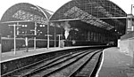
Moss Bank railway station was on the St Helens to Rainford Junction[1] then Ormskirk line on the northern edge of St Helens, England.[2] It opened on 3 February 1858 and closed to passengers on 18 June 1951. The line through the station closed in 1964 and has since been lifted.
The station had distinctive wooden buildings on each platform with curved overhanging roofs[3] to provide protection from inclement weather. Some other stations on the line had buildings of the same pattern.
The station has been demolished. Scafell Road runs through its site.
Services
In July 1922 thirteen "Up" (southbound) trains called at the station on weekdays, with an extra on Saturday evenings. All originated at Ormskirk, several with connections from Southport. Ten Up trains called on Sundays. All trains continued all stations to St Helens. The "Down" (northbound) service was similar.[4]
The trains all consisted of "Motor Cars - One class only". Please note that 'Motor Cars' then did not have their modern meaning, but consisted of a single railway coach joined to a dedicated steam locomotive. Their generic type is summarised in L&YR railmotors. Photographs appear in Bob Pixton's work on the line.[5]
In 1951 the Up service consisted of five trains on weekdays with three extra on Saturdays, all stations to St Helens. The rolling stock was "Third Class Only". No trains called on Sundays. The Down service was similar.
All local trains plying between Ormskirk and St Helens called at Rainford Junction, entailing a reverse. None used the 'direct line' between Bushey Lane Junction[6] and Randle Junction[7] which formed the third side of the triangle shown near the top of the route diagram. That stretch was the preserve of goods trains, diversions and occasional specials.[8]
Private Sidings
A siding was provided immediately south of the station for use by the Gamble Estate. It was small scale and was probably only used for agricultural traffic. It was in use in 1916 but seemed to have closed a few years later.[9]
In 1930 a siding was provided for the contractors building the nearby East Lancashire Road. It had been removed by 28 May 1934 when the road building contract had been completed.[10]
| Preceding station | Disused railways | Following station | ||
|---|---|---|---|---|
| Gerards Bridge Line and station closed | London and North Western Railway St Helens Canal and Railway | Crank Halt Line and station closed |
References
Notes
- ^ Engineers' Line Reference & mileages via railwaycodes
- ^ Smith & Turner 2012, Map 45
- ^ Pixton 1996, p. 101
- ^ Bradshaw 1985, p. 485
- ^ Pixton 1996, pp 87-90 & 101
- ^ Pixton 1996, p. 92
- ^ Pixton 1996, p. 98
- ^ Pixton 1996, p. 102
- ^ Townley & Peden 2002, pp. 519–521
- ^ Townley & Peden 2002, p. 519
Sources
- Bradshaw, George (1985) [July 1922]. Bradshaw's General Railway and Steam Navigation guide for Great Britain and Ireland: A reprint of the July 1922 issue. Newton Abbot: David & Charles. ISBN 978-0-7153-8708-5. OCLC 12500436.
- Pixton, Bob (1996), The Archive Photographs Series Widnes and St Helens Railways, The Chalford Publishing Company, ISBN 0 7524 0751 1
- Smith, Paul; Turner, Keith (2012), Railway Atlas Then and Now, Ian Allan Publishing, ISBN 978 0 7110 3695 6
- Townley, C H A; Peden, J A (2002), Industrial Railways of St Helens, Widnes and Warrington, Part 2, Industrial Railway Society, ISBN 1 901556 25 5
External links
- A more detailed history via Disused Stations UK
- The station on an 1888-1913 Overlay OS Map via National Library of Scotland
- The station on an old O.S. Map via npemaps