Mount Wilson, New South Wales
Town in New South Wales, Australia
33°30′S 150°23′E / 33.500°S 150.383°E / -33.500; 150.383- 130 km (81 mi) NW of Sydney CBD
- 34 km (21 mi) E of Lithgow
| Localities around Mount Wilson: | ||
| Bell | Blue Mountains National Park | Mount Irvine |
| Bell | Mount Wilson | Mount Irvine |
| Blue Mountains National Park | Mount Tomah | Mount Tomah |
| Mount Wilson | |
|---|---|
 Tributary to Waterfall Creek, Waterfall Reserve | |
| Highest point | |
| Elevation | 1,008 m (3,307 ft) |
| Parent peak | Bell Range |
| Coordinates | 33°31′S 150°22′E / 33.517°S 150.367°E / -33.517; 150.367[2] |
| Geography | |
  Mount Wilson Location in New South Wales | |
| Location | Blue Mountains, New South Wales, Australia |
Mount Wilson is a village in the Blue Mountains region of New South Wales, Australia. The village is about 14 kilometres (8.7 mi) east of the township of Bell, and about 100 kilometres (62 mi) west of the Sydney CBD. At the 2021 census, the village of Mount Wilson had a population of 81 people.[1]
Description
Mount Wilson is a long, low mountain formation that sprawls for 5 kilometres (3.1 mi) in the northern Blue Mountains area. It is completely surrounded by the Blue Mountains National Park, a World Heritage Area. It has been partly developed as a residential area, with elaborate gardens that have become a tourist attraction. The area is particularly popular in the autumn when the red and orange leaves give it extra colour. According to some, the "well-organised locals have managed to resist the tidal wave of development which swept through the other mountain towns."[3]

History
The Mount Wilson area was surveyed in 1868 by Edward Wyndham. It was subsequently named after Bowie Wilson, the then Secretary for Lands in the Government of New South Wales.[4] The new township became popular as a summer retreat for the wealthy in the latter part of the 19th century. Extensive gardens were planted around the houses there, taking advantage of the volcanic soils. Historical features that can still be seen include St George's Church, which was built by the children of Henry Marcus Clark and consecrated in 1916; and the house Withycombe, in The Avenue, which was built by George Henry Cox, a grandson of William Cox, who built the first road over the Blue Mountains.[5]
The novelist Patrick White spent some of his youth there, writing about the place in his 1981 memoir Flaws in the Glass; his parents had lived in Mount Wilson between 1912 and 1937. In Flaws in the Glass, he referred to "one of those tedious Australian, would-be tourists attractions called Chinaman's Hat," a reference to a local rock formation.[6]
Heritage listings
Mount Wilson has a number of heritage-listed sites, including:
- 68-78 The Avenue: Wynstay Estate[7]
Activities
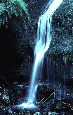
Apart from visiting the gardens for which the area is famous, it is also possible to do a number of walks in places like Waterfall Reserve, the rainforest pocket in Davies Lane, the Cathedral of Ferns, Pheasants Cave, Chinamans Hat and, for more experienced walkers, the track to the Wollangambe River.[8] There are also lookouts, e.g. Wynnes Rocks Lookout and Du Faurs Rocks Lookout. There are no authorised camping areas, but it is possible to camp in the Waterfall Reserve picnic area. The area offers plenty of scope for photography. The village offers easy and delightful cycling on the quiet roads, outside of busy autumn and spring weekends. The 10 km ride to Mt Irvine offers experienced cyclists a very beautiful ride on bitumen road through rainforest and magnificent Blue Mountains Ash forests.
-
 Withycombe, built by George Henry Cox
 -
 Cathedral of Ferns
 -
 St George's Church


See also
 New South Wales portal
 Mountains portal


References
- ^ a b Australian Bureau of Statistics (28 June 2022). "Mount Wilson". 2021 Census QuickStats. Retrieved 21 September 2022.

- ^ "Mount Wilson (mountain)". Geographical Names Register (GNR) of NSW. Geographical Names Board of New South Wales. Retrieved 12 May 2015.
- ^ Smith, Jim (1986). How to See The Blue Mountains. Second Back Row Press. p. 31.
- ^ "Mount Wilson (village)". Geographical Names Register (GNR) of NSW. Geographical Names Board of New South Wales. Retrieved 2 November 2009.
- ^ Hungerford; Donald (1982). Exploring the Blue Mountains. Kangaroo Press. pp. 172–173.
- ^ White, Patrick (1981). Flaws in the Glass. Jonathan Cape.
- ^ "Wynstay Estate". New South Wales State Heritage Register. Department of Planning & Environment. H01520. Retrieved 18 May 2018.
 Text is licensed by State of New South Wales (Department of Planning and Environment) under CC-BY 4.0 licence.
 - ^ Paton, Neil (2004). Sydney and Blue Mountains Bushwalks. Kangaroo Press. pp. 291–298.
External links
Wikivoyage has a travel guide for Mount Wilson.
Wikimedia Commons has media related to Mount Wilson, New South Wales.
- Mount Wilson Website
- Mt Wilson to Bilpin Bush Run - held each August
- Article about Mount Wilson in the Sydney Morning Herald
- Ian Jack (2008). "Mount Wilson". Dictionary of Sydney. Retrieved 28 September 2015. [CC-By-SA]
- v
- t
- e
Blue Mountains topics
and localities
- Bell
- Berambing
- Bilpin
- Blaxland
- Blackheath
- Bullaburra
- Clarence
- Faulconbridge
- Glenbrook
- Hartley Vale
- Hazelbrook
- Katoomba
- Kings Tableland
- Lapstone
- Lawson
- Leura
- Linden
- Little Hartley
- Medlow Bath
- Megalong
- Mount Irvine
- Mount Riverview
- Mount Tomah
- Mount Victoria
- Mount Wilson
- North Katoomba
- Shipley
- Springwood
- Sun Valley
- Valley Heights
- Warrimoo
- Wentworth Falls
- Winmalee
- Woodford
- Yellow Rock
- Yosemite
- Govetts Leap
- Kanangra
- Katoomba Falls
- Wentworth
- 1813 crossing of the Blue Mountains
- Clarence Tunnel
- Glenbrook rail deviations
- 1892
- 1913
- Glenbrook tunnels
- 1892
- 1913
- Lapstone Zig Zag
- Lennox Bridge, Glenbrook
- Lithgow Zig Zag
- Bargo
- Bedford
- Capertee
- Colo
- Coxs
- Du Faur
- Erskine
- Grose
- Hollanders
- Jenolan
- Jooriland
- Kedumba
- Kowmung
- Little (Oberon)
- Little (Wollondilly)
- Macdonald
- Nattai
- Nepean
- Tonalli
- Wingecarribee
- Wolgan
- Wollangambe
- Wollondilly
- Blaxland High
- Blue Mountains Grammar
- Springwood High
- Winmalee High
- Warrimoo Public
- 1999 Glenbrook rail accident
- 2001 Black Christmas / Warragamba bushfires
- 2013 New South Wales Bushfires


