National Register of Historic Places listings in Colquitt County, Georgia
This is a list of properties and districts in Colquitt County, Georgia that are listed on the National Register of Historic Places (NRHP).
Map all coordinates using OpenStreetMap
Download coordinates as:
- KML
- GPX (all coordinates)
- GPX (primary coordinates)
- GPX (secondary coordinates)
This National Park Service list is complete through NPS recent listings posted June 14, 2024.[1]
- v
- t
- e
Properties on the National Register of Historic Places in Georgia by county
- Appling
- Atkinson
- Bacon
- Baker
- Baldwin
- Banks
- Barrow
- Bartow
- Ben Hill
- Berrien
- Bibb
- Bleckley
- Brantley
- Brooks
- Bryan
- Bulloch
- Burke
- Butts
- Calhoun
- Camden
- Candler
- Carroll
- Catoosa
- Charlton
- Chatham
- Chattahoochee
- Chattooga
- Cherokee
- Clarke
- Clay
- Clayton
- Clinch
- Cobb
- Coffee
- Colquitt
- Columbia
- Cook
- Coweta
- Crawford
- Crisp
- Dade
- Dawson
- Decatur
- DeKalb
- Dodge
- Dooly
- Dougherty
- Douglas
- Early
- Echols
- Effingham
- Elbert
- Emanuel
- Evans
- Fannin
- Fayette
- Floyd
- Forsyth
- Franklin
- Fulton
- Gilmer
- Glascock
- Glynn
- Gordon
- Grady
- Greene
- Gwinnett
- Habersham
- Hall
- Hancock
- Haralson
- Harris
- Hart
- Heard
- Henry
- Houston
- Irwin
- Jackson
- Jasper
- Jeff Davis
- Jefferson
- Jenkins
- Johnson
- Jones
- Lamar
- Lanier
- Laurens
- Lee
- Liberty
- Lincoln
- Long
- Lowndes
- Lumpkin
- Macon
- Madison
- Marion
- McDuffie
- McIntosh
- Meriwether
- Miller
- Mitchell
- Monroe
- Montgomery
- Morgan
- Murray
- Muscogee
- Newton
- Oconee
- Oglethorpe
- Paulding
- Peach
- Pickens
- Pierce
- Pike
- Polk
- Pulaski
- Putnam
- Quitman
- Rabun
- Randolph
- Richmond
- Rockdale
- Schley
- Screven
- Seminole
- Spalding
- Stephens
- Stewart
- Sumter
- Talbot
- Taliaferro
- Tattnall
- Taylor
- Telfair
- Terrell
- Thomas
- Tift
- Toombs
- Towns
- Treutlen
- Troup
- Turner
- Twiggs
- Union
- Upson
- Walker
- Walton
- Ware
- Warren
- Washington
- Wayne
- Webster
- Wheeler
- White
- Whitfield
- Wilcox
- Wilkes
- Wilkinson
- Worth

Current listings
| [2] | Name on the Register | Image | Date listed[3] | Location | City or town | Description |
|---|---|---|---|---|---|---|
| 1 | W. W. Ashburn House | Upload image | July 15, 1982 (#82002396) | 609 1st Ave. 31°10′43″N 83°47′45″W / 31.17863°N 83.79584°W / 31.17863; -83.79584 (W. W. Ashburn House) | Moultrie | Is visible in bird's-eye view but gone in satellite view; this house was moved to Brooks County, GA, in pieces sometime in late 2012 or early 2013, exact location unknown |
| 2 | Carnegie Library of Moultrie |  | July 15, 1982 (#82002397) | 39 N. Main St. 31°10′50″N 83°47′21″W / 31.180556°N 83.789167°W / 31.180556; -83.789167 (Carnegie Library of Moultrie) | Moultrie | |
| 3 | James W. Coleman House |  | December 22, 1983 (#83003555) | GA 33 31°13′28″N 83°47′49″W / 31.224444°N 83.796944°W / 31.224444; -83.796944 (James W. Coleman House) | Moultrie | |
| 4 | Colquitt County Courthouse | 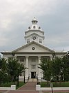 | September 18, 1980 (#80001003) | Courthouse Sq. 31°10′45″N 83°47′18″W / 31.179167°N 83.788333°W / 31.179167; -83.788333 (Colquitt County Courthouse) | Moultrie | |
| 5 | Colquitt County Jail |  | October 10, 1980 (#80001004) | 126 1st Ave., SE 31°10′42″N 83°47′12″W / 31.178333°N 83.786667°W / 31.178333; -83.786667 (Colquitt County Jail) | Moultrie | |
| 6 | Mother Easter Baptist Church and Parsonage | 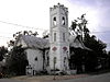 | April 1, 1999 (#99000413) | 400 Second Ave., NW 31°10′55″N 83°47′37″W / 31.182°N 83.7937°W / 31.182; -83.7937 (Mother Easter Baptist Church and Parsonage) | Moultrie | |
| 7 | Moultrie Commercial Historic District |  | June 3, 1994 (#94000543) | Roughly bounded by NE. First Ave., SE. Second Ave., W. First St. and E. Fourth St. 31°10′48″N 83°47′14″W / 31.18°N 83.787222°W / 31.18; -83.787222 (Moultrie Commercial Historic District) | Moultrie | Colquitt Towers - former hotel called Hotel Colquitt |
| 8 | Moultrie High School |  | June 17, 1982 (#82002398) | 401 7th Ave. SW 31°10′20″N 83°47′40″W / 31.172222°N 83.794444°W / 31.172222; -83.794444 (Moultrie High School) | Moultrie | |
| 9 | Henry Crawford Tucker Log House and Farmstead | Upload image | July 26, 1982 (#82002399) | Off GA 37 31°12′37″N 83°50′39″W / 31.210278°N 83.844167°W / 31.210278; -83.844167 (Henry Crawford Tucker Log House and Farmstead) | Moultrie | Moultrie Observer |
References
- ^ National Park Service, United States Department of the Interior, "National Register of Historic Places: Weekly List Actions", retrieved June 14, 2024.
- ^ Numbers represent an alphabetical ordering by significant words. Various colorings, defined here, differentiate National Historic Landmarks and historic districts from other NRHP buildings, structures, sites or objects.
- ^ The eight-digit number below each date is the number assigned to each location in the National Register Information System database, which can be viewed by clicking the number.
Wikimedia Commons has media related to National Register of Historic Places in Colquitt County, Georgia.


