National Register of Historic Places listings in Porter County, Indiana

This is a list of the National Register of Historic Places listings in Porter County, Indiana.
This is intended to be a complete list of the properties and districts on the National Register of Historic Places in Porter County, Indiana, United States. Latitude and longitude coordinates are provided for many National Register properties and districts; these locations may be seen together in a map.[1]
There are 39 properties and districts listed on the National Register in the county, including 1 National Historic Landmark.
Properties and districts located in incorporated areas display the name of the municipality, while properties and districts in unincorporated areas display the name of their civil township. Properties and districts split between multiple jurisdictions display the names of all jurisdictions.
This National Park Service list is complete through NPS recent listings posted May 31, 2024.[2]
Map all coordinates using OpenStreetMap
Download coordinates as:
- KML
- GPX (all coordinates)
- GPX (primary coordinates)
- GPX (secondary coordinates)
Current listings
| [3] | Name on the Register[4] | Image | Date listed[5] | Location | City or town | Description |
|---|---|---|---|---|---|---|
| 1 | Joseph Bailly Homestead |  | October 15, 1966 (#66000005) | West of Porter on U.S. Route 20 on the Indiana Dunes National Lakeshore 41°37′23″N 87°05′39″W / 41.623056°N 87.094167°W / 41.623056; -87.094167 (Joseph Bailly Homestead) | Porter | Joseph Bailly acquired the Homestead and surrounding lands during the 1830s when the Calumet was opened to white settlement. When he died in 1835, the Homestead went to his wife. |
| 2 | Bartlett Real Estate Office |  | March 23, 2004 (#04000208) | 500 S. Broadway 41°40′24″N 86°59′12″W / 41.673333°N 86.986667°W / 41.673333; -86.986667 (Bartlett Real Estate Office) | Beverly Shores | Within Indiana Dunes National Park. |
| 3 | Beverly Shores South Shore Railroad Station |  | July 19, 1989 (#89000411) | Broadway Ave. and U.S. Route 12 41°40′24″N 86°59′09″W / 41.673333°N 86.985833°W / 41.673333; -86.985833 (Beverly Shores South Shore Railroad Station) | Beverly Shores | Beverly Shores Station is the last example of the "Insull Spanish" architecture style used for station houses along the electric railroad lines acquired by Samuel Insull in the first part of the twentieth century. Within Indiana Dunes National Park. |
| 4 | Beverly Shores-Century of Progress Architectural District |  | June 30, 1986 (#86001472) | 208, 210, 212, 214, and 215 Lake Front Dr. 41°41′03″N 87°00′06″W / 41.684167°N 87.001667°W / 41.684167; -87.001667 (Beverly Shores-Century of Progress Architectural District) | Beverly Shores | The Century of Progress Architectural District consists of five buildings, all from the Homes of Tomorrow Exhibition during the 1933 Century of Progress World's Fair which took place in Chicago. Within Indiana Dunes National Park. |
| 5 | Conrad and Catherine Bloch House |  | June 23, 2011 (#11000386) | 608 Academy St. 41°28′25″N 87°03′52″W / 41.473611°N 87.064444°W / 41.473611; -87.064444 (Conrad and Catherine Bloch House) | Valparaiso | |
| 6 | George Brown Mansion | 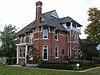 | August 28, 1998 (#98001101) | 700 W. Porter Ave. 41°36′25″N 87°03′41″W / 41.606944°N 87.061389°W / 41.606944; -87.061389 (George Brown Mansion) | Chesterton | |
| 7 | Chesterton Commercial Historic District |  | September 9, 1999 (#99001102) | 109-193 N. Calumet Rd. and 130-134 N. Calumet Rd. 41°36′39″N 87°03′08″W / 41.610833°N 87.052222°W / 41.610833; -87.052222 (Chesterton Commercial Historic District) | Chesterton | The town's location along the railroad helped industry to grow. Soon, there was a cooperage, sawmills, a washing machine factory, and an organ company. Among the better examples of the towns growth are the commercial building on the southwest corner of Broadway and Calumet Rd, and the old Chesterton Tribune Building. |
| 8 | Chesterton Residential Historic District |  | December 24, 2009 (#09001134) | Roughly a two-block area between Lincoln and W. Indiana Aves. 41°36′32″N 87°03′13″W / 41.608889°N 87.053611°W / 41.608889; -87.053611 (Chesterton Residential Historic District) | Chesterton | |
| 9 | Chicago Mica Co.- Continental Diamond Fibre Co.-ANCO Factory | Upload image | December 26, 2023 (#100009652) | 350 South Campbell Street 41°27′52″N 87°03′58″W / 41.4644°N 87.0661°W / 41.4644; -87.0661 (Chicago Mica Co.- Continental Diamond Fibre Co.-ANCO Factory) | Valparaiso | |
| 10 | Patrick and Catherine Clifford House | Upload image | November 16, 2021 (#100007173) | 106 Washington St. 41°28′10″N 87°03′40″W / 41.4694°N 87.0610°W / 41.4694; -87.0610 (Patrick and Catherine Clifford House) | Valparaiso | |
| 11 | Collier Lodge site | 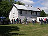 | December 24, 2009 (#09001133) | 1099 Baum's Bridge Rd., southwest of Kouts[6] 41°16′32″N 87°04′18″W / 41.275556°N 87.071667°W / 41.275556; -87.071667 (Collier Lodge site) | Pleasant Township | |
| 12 | Norris and Harriet Coambs Lustron House |  | September 17, 1992 (#92001165) | 411 Bowser Ave. 41°36′29″N 87°02′44″W / 41.607917°N 87.045694°W / 41.607917; -87.045694 (Norris and Harriet Coambs Lustron House) | Chesterton | |
| 13 | Dune Acres Clubhouse | 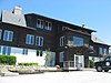 | January 25, 2007 (#06001295) | Clubhouse Dr. 41°39′08″N 87°05′10″W / 41.652222°N 87.086111°W / 41.652222; -87.086111 (Dune Acres Clubhouse) | Dune Acres | |
| 14 | Clinton D. Gilson Barn |  | September 20, 1984 (#84001229) | 522 W. 650S, northeast of Hebron 41°20′22″N 87°09′59″W / 41.339444°N 87.166389°W / 41.339444; -87.166389 (Clinton D. Gilson Barn) | Boone Township | |
| 15 | Good Fellow Club Youth Camp |  | August 8, 2013 (#13000593) | 700 Howe Rd. 41°37′36″N 87°06′02″W / 41.626667°N 87.100556°W / 41.626667; -87.100556 (Good Fellow Club Youth Camp) | Porter | Within Indiana Dunes National Park. |
| 16 | Haste-Crumpacker House | 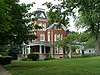 | June 24, 2010 (#10000374) | 208 N Michigan St. 41°28′14″N 87°03′31″W / 41.470556°N 87.058611°W / 41.470556; -87.058611 (Haste-Crumpacker House) | Valparaiso | |
| 17 | Heritage Hall |  | July 12, 1976 (#76000016) | Campus Mall, S. College Ave. 41°27′43″N 87°03′15″W / 41.461944°N 87.054167°W / 41.461944; -87.054167 (Heritage Hall) | Valparaiso | Heritage Hall is the oldest building on the campus of Valparaiso University. Erected in 1875, the building was named Flint Hall after the contractor. It was renamed after Richard Aaron Heritage, head of the music department from 1878-1894. |
| 18 | Imre and Maria Horner House |  | September 25, 1996 (#96001006) | 2 Merrivale Ave. 41°41′32″N 86°58′46″W / 41.692361°N 86.979444°W / 41.692361; -86.979444 (Imre and Maria Horner House) | Beverly Shores | |
| 19 | Hour Glass Cottage | Upload image | August 31, 2023 (#100009294) | 8 Lupine Ln. 41°37′26″N 87°11′35″W / 41.6238°N 87.1930°W / 41.6238; -87.1930 (Hour Glass Cottage) | Ogden Dunes | |
| 20 | Immanuel Lutheran Church |  | February 19, 1982 (#82000028) | 308 N. Washington St. 41°28′17″N 87°03′39″W / 41.471389°N 87.060833°W / 41.471389; -87.060833 (Immanuel Lutheran Church) | Valparaiso | The congregation was founded in 1862 by 45 German families. The church was erected in 1891 by Henry Lemster and his son Charles. |
| 21 | Dr. David J. Loring Residence and Clinic |  | December 6, 1984 (#84000520) | 102 Washington St. 41°28′09″N 87°03′38″W / 41.469028°N 87.060556°W / 41.469028; -87.060556 (Dr. David J. Loring Residence and Clinic) | Valparaiso | The Loring Residence and Clinic was the first facility built to provide medical services to the community. Dr Loring used his home as his medical office until his death in 1914. |
| 22 | William McCallum House | 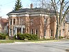 | January 25, 2007 (#06001293) | 507 E. Lincolnway 41°28′05″N 87°03′14″W / 41.468056°N 87.053889°W / 41.468056; -87.053889 (William McCallum House) | Valparaiso | |
| 23 | Charles S. and Mary McGill House |  | June 25, 2013 (#13000426) | 505 N. Washington St. 41°28′22″N 87°03′41″W / 41.472778°N 87.061389°W / 41.472778; -87.061389 (Charles S. and Mary McGill House) | Valparaiso | |
| 24 | Dr. John and Gerda Meyer House |  | November 28, 2012 (#12000974) | 360 W. Fairwater Ave. 41°40′52″N 87°00′29″W / 41.681111°N 87.008194°W / 41.681111; -87.008194 (Dr. John and Gerda Meyer House) | Beverly Shores | Within Indiana Dunes National Park. |
| 25 | New York Central Railroad Passenger Depot |  | August 28, 1998 (#98001103) | 220 Broadway 41°36′41″N 87°03′16″W / 41.611389°N 87.054444°W / 41.611389; -87.054444 (New York Central Railroad Passenger Depot) | Chesterton | |
| 26 | Nike Missile Site C47 | 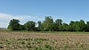 | January 21, 2000 (#99001669) | County Roads 600N and 700N, south of Portage 41°31′24″N 87°10′40″W / 41.523333°N 87.177778°W / 41.523333; -87.177778 (Nike Missile Site C47) | Portage Township | One of 300 Nike missile bases, and one of a dozen located around Chicago. The sites were decommissioned and sold. This is one of the more complete sites. The administrative area is used as a paintball site, while the launch site remains in government ownership. |
| 27 | Porter County Jail and Sheriff's House |  | June 23, 1976 (#76000017) | 153 Franklin St. 41°27′59″N 87°03′34″W / 41.466389°N 87.059444°W / 41.466389; -87.059444 (Porter County Jail and Sheriff's House) | Valparaiso | The sheriff’s residence was built in 1860. The structure is Italianate in design. It is located on East Indiana Ave, which was Mechanic Street when the house was built. The Jail was added in 1871. |
| 28 | Porter County Memorial Hall |  | May 23, 1984 (#84001231) | 104 Indiana Ave. 41°28′00″N 87°03′33″W / 41.466667°N 87.059167°W / 41.466667; -87.059167 (Porter County Memorial Hall) | Valparaiso | Originally, the Chaplain Brown GAR Post No. 106. Designed in 1892 by local architect, Charles F. Lembke, using Romanesque styling, it was built in 1892-3 to seat 100 people. It was also used as the local opera house. |
| 29 | Porter Town Hall |  | June 29, 2000 (#00000678) | 303 Franklin St. 41°36′59″N 87°04′20″W / 41.616250°N 87.072222°W / 41.616250; -87.072222 (Porter Town Hall) | Porter | Replaced by a modern structure in 2006. |
| 30 | Read Dunes House |  | December 8, 2011 (#10000858) | 1453 Tremont Rd., north of Chesterton 41°38′40″N 87°02′52″W / 41.644444°N 87.047778°W / 41.644444; -87.047778 (Read Dunes House) | Westchester Township | Within Indiana Dunes National Park. |
| 31 | David Garland Rose House |  | July 17, 1980 (#80000030) | 156 Garfield St. 41°27′59″N 87°03′06″W / 41.466250°N 87.051667°W / 41.466250; -87.051667 (David Garland Rose House) | Valparaiso | The David Garland Rose House was built circa 1860 in Valparaiso, Indiana, USA. This Gothic Revival house is unusual in that it is eight-sided, an octagon. |
| 32 | Eli Sigler House |  | March 21, 2011 (#11000124) | 104 W. Church St. 41°19′03″N 87°12′01″W / 41.317500°N 87.200278°W / 41.317500; -87.200278 (Eli Sigler House) | Hebron | |
| 33 | DeForest Skinner House |  | June 24, 2008 (#08000568) | 208 Washington St. 41°28′14″N 87°03′39″W / 41.470556°N 87.060833°W / 41.470556; -87.060833 (DeForest Skinner House) | Valparaiso | |
| 34 | Solomon Enclave |  | April 27, 2011 (#11000220) | 901, 903, 907 E. Lake Front Dr. 41°41′58″N 86°57′44″W / 41.699444°N 86.962222°W / 41.699444; -86.962222 (Solomon Enclave) | Beverly Shores | Within Indiana Dunes National Park. |
| 35 | Valparaiso Downtown Commercial District |  | February 23, 1990 (#90000327) | Roughly bounded by Jefferson, Morgan, Indiana, and Napoleon; also the northwestern corner of the junction of Lincolnway and Napoleon St. 41°28′02″N 87°03′37″W / 41.467222°N 87.060278°W / 41.467222; -87.060278 (Valparaiso Downtown Commercial District) | Valparaiso | Second set of addresses represents a boundary increase of December 27, 2010 |
| 36 | Valparaiso University Chapel of the Resurrection |  | November 16, 2021 (#100007172) | 1600 Chapel Dr. 41°27′48″N 87°02′32″W / 41.4633°N 87.0422°W / 41.4633; -87.0422 (Valparaiso University Chapel of the Resurrection) | Valparaiso | |
| 37 | Weller House |  | April 22, 1982 (#82000029) | 1200 North Rd., east of Chesterton 41°36′26″N 86°57′04″W / 41.607222°N 86.951111°W / 41.607222; -86.951111 (Weller House) | Pine Township | |
| 38 | Josephus Wolf House |  | December 19, 2007 (#07001281) | 453 W. 700N, northwest of Valparaiso 41°32′11″N 87°09′14″W / 41.536278°N 87.153889°W / 41.536278; -87.153889 (Josephus Wolf House) | Portage Township | |
| 39 | Martin Young House |  | March 29, 2007 (#07000208) | 324 2nd St. 41°36′29″N 87°03′15″W / 41.608194°N 87.054028°W / 41.608194; -87.054028 (Martin Young House) | Chesterton |
See also
Wikimedia Commons has media related to National Register of Historic Places in Porter County, Indiana.
- List of National Historic Landmarks in Indiana
- National Register of Historic Places listings in Indiana
- Listings in neighboring counties: Berrien (MI), Jasper, Lake, LaPorte, Starke
- List of Indiana state historical markers in Porter County
References
- ^ The latitude and longitude information provided in this table was derived originally from the National Register Information System, which has been found to be fairly accurate for about 99% of listings. Some locations in this table may have been corrected to current GPS standards.
- ^ National Park Service, United States Department of the Interior, "National Register of Historic Places: Weekly List Actions", retrieved May 31, 2024.
- ^ Numbers represent an alphabetical ordering by significant words. Various colorings, defined here, differentiate National Historic Landmarks and historic districts from other NRHP buildings, structures, sites or objects.
- ^ "National Register Information System". National Register of Historic Places. National Park Service. March 13, 2009.
- ^ The eight-digit number below each date is the number assigned to each location in the National Register Information System database, which can be viewed by clicking the number.
- ^ Location derived from the relevant agenda of the Indiana Historic Preservation Review Board; the NRIS lists the site as "Address Restricted"
- v
- t
- e
- List of U.S. National Historic Landmarks by state:
- Alabama
- Alaska
- Arizona
- Arkansas
- California
- Colorado
- Connecticut
- Delaware
- Florida
- Georgia
- Hawaii
- Idaho
- Illinois
- Indiana
- Iowa
- Kansas
- Kentucky
- Louisiana
- Maine
- Maryland
- Massachusetts
- Michigan
- Minnesota
- Mississippi
- Missouri
- Montana
- Nebraska
- Nevada
- New Hampshire
- New Jersey
- New Mexico
- New York
- North Carolina
- North Dakota
- Ohio
- Oklahoma
- Oregon
- Pennsylvania
- Rhode Island
- South Carolina
- South Dakota
- Tennessee
- Texas
- Utah
- Vermont
- Virginia
- Washington
- West Virginia
- Wisconsin
- Wyoming
 National Register of Historic Places portal
 Category


Municipalities and communities of Porter County, Indiana, United States | ||
|---|---|---|
County seat: Valparaiso | ||
| Cities |  | |
| Towns | ||
| Townships | ||
| CDPs | ||
| Other communities | ||
| Ghost towns | ||
| Footnotes | ‡This populated place also has portions in an adjacent county or counties | |
| ||


