National Register of Historic Places listings in Tallahatchie County, Mississippi

This is a list of the National Register of Historic Places listings in Tallahatchie County, Mississippi.
This is intended to be a complete list of the properties and districts on the National Register of Historic Places in Tallahatchie County, Mississippi, United States. Latitude and longitude coordinates are provided for many National Register properties and districts; these locations may be seen together in a map.[1]
There are 10 properties and districts listed on the National Register in the county.
This National Park Service list is complete through NPS recent listings posted June 7, 2024.[2]
Map all coordinates using OpenStreetMap
Download coordinates as:
- KML
- GPX (all coordinates)
- GPX (primary coordinates)
- GPX (secondary coordinates)
Current listings
| [3] | Name on the Register | Image | Date listed[4] | Location | City or town | Description |
|---|---|---|---|---|---|---|
| 1 | Allison Mound (22Tl1024) | Upload image | December 14, 1988 (#88002708) | Address restricted[5] | Webb | |
| 2 | Black Bayou Bridge | Upload image | March 21, 2011 (#11000112) | 2nd St. 33°49′26″N 90°17′38″W / 33.823889°N 90.293889°W / 33.823889; -90.293889 (Black Bayou Bridge) | Glendora | |
| 3 | Buford Site (22Tl501) | Upload image | October 15, 1986 (#86002797) | Southeastern quarter of the southwestern quarter of Section 36, Township 25 North, Range 2 West[6]: 58 33°59′14″N 90°21′28″W / 33.987222°N 90.357778°W / 33.987222; -90.357778 (Buford Site (22Tl501)) | Sumner | |
| 4 | Dell Bullion Mound (22Tl998) | Upload image | December 14, 1988 (#88002706) | Address restricted[5] | Grenada | |
| 5 | Dr. Tandy and Sarah Harrison House | 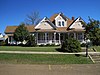 | January 24, 2019 (#100003346) | 112 S. Panola St. 34°00′23″N 90°03′25″W / 34.0063°N 90.0570°W / 34.0063; -90.0570 (Dr. Tandy and Sarah Harrison House) | Charleston | |
| 6 | Jacks Site | Upload image | March 24, 1978 (#78001630) | Address restricted[5] | Philipp | |
| 7 | Lamb-Fish Bridge | Upload image | May 17, 1982 (#82004631) | Northwest of Charleston 34°01′20″N 90°11′32″W / 34.022222°N 90.192222°W / 34.022222; -90.192222 (Lamb-Fish Bridge) | Charleston | |
| 8 | Murphey-Jennings House | Upload image | March 25, 1982 (#82004632) | 307 Walnut St. 33°58′01″N 90°22′10″W / 33.966944°N 90.369444°W / 33.966944; -90.369444 (Murphey-Jennings House) | Sumner | |
| 9 | Spivey Site | Upload image | December 6, 1978 (#78001629) | Address restricted[5] | Crowder | |
| 10 | Tallahatchie County Second District Courthouse |  | March 6, 2007 (#07000149) | 108 Main St. 33°58′13″N 90°22′10″W / 33.970278°N 90.369444°W / 33.970278; -90.369444 (Tallahatchie County Second District Courthouse) | Sumner |
See also
Wikimedia Commons has media related to National Register of Historic Places in Tallahatchie County, Mississippi.
- List of National Historic Landmarks in Mississippi
- National Register of Historic Places listings in Mississippi
References
- ^ The latitude and longitude information provided in this table was derived originally from the National Register Information System, which has been found to be fairly accurate for about 99% of listings. Some locations in this table may have been corrected to current GPS standards.
- ^ National Park Service, United States Department of the Interior, "National Register of Historic Places: Weekly List Actions", retrieved June 7, 2024.
- ^ Numbers represent an alphabetical ordering by significant words. Various colorings, defined here, differentiate National Historic Landmarks and historic districts from other NRHP buildings, structures, sites or objects.
- ^ The eight-digit number below each date is the number assigned to each location in the National Register Information System database, which can be viewed by clicking the number.
- ^ a b c d Federal and state laws and practices restrict general public access to information regarding the specific location of this resource. In some cases, this is to protect archeological sites from vandalism, while in other cases it is restricted at the request of the owner. See: Knoerl, John; Miller, Diane; Shrimpton, Rebecca H. (1990), Guidelines for Restricting Information about Historic and Prehistoric Resources, National Register Bulletin, National Park Service, U.S. Department of the Interior, OCLC 20706997.
- ^ Phillips, Philip, et al. Archaeological Survey in the Lower Mississippi Alluvial Valley 1940-1947. Reprint ed. Tuscaloosa: U of Alabama P, 2003.
- v
- t
- e
by county
- Adams
- Alcorn
- Amite
- Attala
- Benton
- Bolivar
- Calhoun
- Carroll
- Chickasaw
- Choctaw
- Claiborne
- Clarke
- Clay
- Coahoma
- Copiah
- Covington
- DeSoto
- Forrest
- Franklin
- George
- Greene
- Grenada
- Hancock
- Harrison
- Hinds
- Holmes
- Humphreys
- Issaquena
- Itawamba
- Jackson
- Jasper
- Jefferson
- Jefferson Davis
- Jones
- Kemper
- Lafayette
- Lamar
- Lauderdale
- Lawrence
- Leake
- Lee
- Leflore
- Lincoln
- Lowndes
- Madison
- Marion
- Marshall
- Monroe
- Montgomery
- Neshoba
- Newton
- Noxubee
- Oktibbeha
- Panola
- Pearl River
- Perry
- Pike
- Pontotoc
- Prentiss
- Quitman
- Rankin
- Scott
- Sharkey
- Simpson
- Smith
- Stone
- Sunflower
- Tallahatchie
- Tate
- Tippah
- Tishomingo
- Tunica
- Union
- Walthall
- Warren
- Washington
- Wayne
- Webster
- Wilkinson
- Winston
- Yalobusha
- Yazoo

Municipalities and communities of Tallahatchie County, Mississippi, United States | ||
|---|---|---|
County seats: Charleston and Sumner | ||
| City | 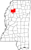 | |
| Towns | ||
| Village | ||
| Unincorporated communities | ||
| Ghost towns | ||
| Footnotes | ‡This populated place also has portions in an adjacent county or counties | |
| ||


