Old Kent Road railway station
Former railway station in England

Old Kent Road was a railway station on the South London line section of London, Brighton and South Coast Railway in south London, England. It took its name from the Old Kent Road on which it was located. The station opened on 13 August 1866 and closed on 1 January 1917.
History
The station opened on 13 August 1866 as part of the initial South London line service between London Bridge and Loughborough Park.[1][2] Service was extended from Loughborough Park to Victoria on 1 May 1867.[3]
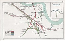
It was located on a viaduct to the south of Old Kent Road in the Peckham division of the parish of Camberwell. The boundary with the hamlet of Hatcham in the parish of St Paul Deptford was located just to the east of the station. The railway crossed the road on a bridge.
To the north the next station was South Bermondsey and to the south the next station was Queen's Road. The station was renamed in 1870 to Old Kent Road and Hatcham.
South London line service converted to overhead electric traction from 1 December 1909 and was marketed as the South London Elevated Electric Railway.[3]
The station closed temporarily on 1 January 1917 during the First World War as an economy measure, but was not reopened after the end of the war despite public complaints.[3]
East London Railway connection
To the north of Old Kent Road the Old Kent Road junction provided a connection to Deptford Road on the East London Railway.
LBSCR passenger service between Old Kent Road and Wapping on the East London Railway commenced on 13 March 1871. Services were extended to Liverpool Street on 11 April 1876 and Peckham Rye on 1 August 1877. From 31 December 1885 the service was cut back to Shoreditch from Liverpool Street.[3]
The passenger train service to East London was withdrawn on 1 June 1911 and the track was removed in 1912.[4]
The connection to the East London line from Old Kent Road junction was restored in December 2012 with services operated by the London Overground.
Proposed new stations
A new station named Surrey Canal on the London Overground is proposed to be situated about 700 metres north of the site of the former Old Kent Road station.[5]
A new London Underground station at Old Kent Road was proposed in 2014 as part of plans for the Bakerloo line extension,[6] for which the route has been safeguarded, as of 2021.[7]
References
- ^ Borley, H. V. (1982). Chronology of London railways. Oakham, Leisc: Railway & Canal Historical Soc. ISBN 0901461334.
- ^ London's Disused Stations by J.E.Connor
- ^ a b c d Mitchell, Vic; Smith, Keith (1995). South London Line: London Bridge to Victoria. Middleton Press. ISBN 1873793464.
- ^ Londons Disused Stations Volume 6 by J.E.Connor
- ^ Johnson, Thomas (30 October 2023). "TfL seeks funding options for long-awaited Surrey Canal Overground station". New Civil Engineer. Retrieved 20 February 2024.
- ^ Foley, Amanda (1 October 2014). "£3bn Bakerloo Line expansion unveiled". The Tunnelling Journal.
- ^ "Bakerloo line extension: safeguarding directions". GOV.UK. Retrieved 27 March 2024.
| Preceding station | Disused railways | Following station | ||
|---|---|---|---|---|
| Queen's Road Peckham | London, Brighton & South Coast Railway | South Bermondsey |
- v
- t
- e
- Addiscombe
- Alexandra Palace
- Angel Road
- Bandon Halt
- Bath Road Halt
- Battersea
- Battersea Park
- Battersea Park Road
- Beckton
- Beddington Lane
- Belmont
- Bingham Road
- Bishopsgate
- Bishopsgate (Low Level)
- Blackfriars Bridge
- Blackfriars Road
- Blackheath Hill
- Blackwall
- Borough Road
- Bow
- Bow Road
- Brentford
- Brentham for North Ealing and Greystoke Park
- Bricklayers Arms
- Broad Street
- Brockley Lane
- Burdett Road
- Camberwell
- Camden Road (Midland)
- Cannon Street Road
- Carterhatch Lane Halt
- Central
- Central Croydon
- Chelsea & Fulham
- Church Manor Way Halt
- Clapham Common
- Coborn Road
- Commercial Dock
- Connaught Road
- Coombe Road
- Coulsdon North
- Cowley
- Cranley Gardens
- Crouch End
- Crowlands
- Crystal Palace (High Level)
- Devonshire Street
- Dudding Hill
- East Brixton
- Edgware
- Eltham Park
- Eltham Well Hall
- Enfield
- Finchley Road
- Gallions
- Globe Road & Devonshire Street
- Greenwich Park
- Grosvenor Road
- Haggerston
- Hammersmith & Chiswick
- Hammersmith (Grove Road)
- Harlesden
- Haverstock Hill
- Heathrow Junction
- Highgate
- Highgate Road
- Holborn Viaduct
- Holloway & Caledonian Road
- Holloway car dock
- Honor Oak
- Hornsey Road
- Junction Road
- Kensal Green & Harlesden
- Kew
- King's Cross Thameslink
- Leman Street
- Lewisham Road
- Limehouse
- Lordship Lane
- Lower Edmonton (Low Level)
- Ludgate Hill
- Maiden Lane
- Manor Way
- Merton Abbey
- Merton Park
- Mildmay Park
- Mile End
- Mill Hill (The Hale)
- Millwall Docks
- Millwall Junction
- Minories
- Mitcham
- Morden Road
- Muswell Hill
- Necropolis
- New Wandsworth
- Nine Elms
- Noel Park & Wood Green
- North Acton
- North Greenwich
- North Woolwich
- Old Ford
- Old Kent Road
- Old Oak Lane Halt
- Palace Gates
- Park Royal
- Park Royal West Halt
- Perivale Halt
- Pimlico terminus
- Poplar
- Poplar (East India Road)
- Primrose Hill
- Rugby Road Halt
- Selsdon
- Shadwell & St. George's East
- Shepherd's Bush
- Shern Hall Street
- Shoreditch
- Silvertown
- South Bromley
- South Dock
- South Harefield Halt
- Southwark Park
- Spa Road
- Spencer Road Halt
- St. Ann's Road
- St. Quintin Park & Wormwood Scrubs
- Stanmore Village
- Stewarts Lane
- Stratford Market
- Stroud Green
- Tidal Basin
- Tooting Junction
- Trumpers Crossing Halte
- Twyford Abbey Halt
- Upper Sydenham
- Uxbridge High Street
- Uxbridge Road
- Uxbridge Vine Street
- Victoria Park
- Victoria Park & Bow
- Waddon Marsh
- Walworth Road
- Welsh Harp
- Wembley Stadium
- West Green
- West India Docks
- Willesden
- Woodside
- Woodstock Road Halt

Broad Street (1865–1986)
51°28′42″N 0°03′16″W / 51.4782°N 0.0545°W / 51.4782; -0.0545


