Pittsford Green Historic District
Historic district in Vermont, United States
United States historic place
Pittsford Green Historic District | |
 | |
43°42′26″N 73°1′44″W / 43.70722°N 73.02889°W / 43.70722; -73.02889 | |
| Area | 15 acres (6.1 ha) |
|---|---|
| Architectural style | Mid 19th Century Revival, Federal, Late Victorian |
| NRHP reference No. | 82001704[1] |
| Added to NRHP | May 13, 1982 |
The Pittsford Green Historic District encompasses the heart of the traditional village center of Pittsford, Vermont. Centered on a stretch of United States Route 7, the village's development began in the late 18th century, and now consists almost entirely of buildings from the 19th century. The district was listed on the National Register of Historic Places in 1982.[1]
Description and history
The area that is now the town of Pittsford was first permanently settled by colonists in 1769, and the area that is now its village center began to take shape around 1795, with the opening of a tavern, the founding by Israel Keith of an iron foundry nearby, and the establishment of a marble quarry by Jeremiah Sheldon across Otter Creek to the west. The village became a stagecoach stop on the main road between Rutland and Vergennes, now United States Route 7. The village green, located on the east side of US 7, took a more definite shape with the construction of the Congregational Church in 1837. By the turn of the 20th century, most of the area's industries were in decline, the marble quarries being the notable exception.[2]
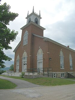
The historic district extends from the northern end of the village green southward along Main Street (US 7), to a four-way junction with Elm and Arch Streets where US 7 turns sharply to the east. The village green is roughly triangular in shape, and is lined on the east side by houses, with the Congregational Church set prominently on a rise at its north end. Most of the buildings in the district are wood frame residences. There are only five brick buildings: one is the church, another is the Romanesque Maclure (Walker Memorial) Library (1894–95). Five of the surviving houses date to the 1790s, representing the earliest surviving period of development.[2]
See also
References
- ^ a b "National Register Information System". National Register of Historic Places. National Park Service. July 9, 2010.
- ^ a b "NRHP nomination for Pittsford Green Historic District". National Park Service. Retrieved April 23, 2016.
- v
- t
- e
National Register of Historic Places in Rutland County, Vermont
Historic
Landmark
- Brown Covered Bridge

- Benson Village
- Brandon State School
- Brandon Village Historic District
- Castleton Village Historic District
- Danby Village Historic District
- East Poultney Historic District
- Fair Haven Green Historic District
- Gifford Woods State Park
- Hosford–Sherman Farm
- Kingsley Grist Mill Historic District
- Marble Street Historic District
- Middletown Springs Historic District
- Mission of the Church of Our Savior
- Mountain View Stock Farm
- Pittsford Green Historic District
- Poultney Main Street Historic District
- Rural Otter Creek Valley Historic District
- Rutland Courthouse Historic District
- Rutland Downtown Historic District
- Simeon Smith Mansion
- Tinmouth Historic District
- Wallingford Main Street Historic District
| Commercial |
|
|---|---|
| Education |
|
| Government | |
| Industrial | |
| Religious | |
| Residential |
|
| Transportation |
- Bridge 4
- Colburn Bridge
- Cold River Bridge
- Cooley Covered Bridge
- Dean Covered Bridge
- Depot Covered Bridge
- Gorham Covered Bridge
- Hammond Covered Bridge
- Kingsley Covered Bridge
- Marble Bridge
- Sanderson Covered Bridge


