Plata Bridge
Historic bridge in Bayamón and Naranjito municipalities, Puerto Rico
United States historic place
Plata Bridge | |
 | |
| 18°18′14″N 66°12′41″W / 18.30384°N 66.21132°W / 18.30384; -66.21132 | |
| Built | 1908 |
|---|---|
| Built by | American Bridge Co., Groton Bridge Co., Jose Lago |
| Architectural style | Parker truss |
| MPS | Historic Bridges of Puerto Rico MPS |
| NRHP reference No. | 95000849[1] |
| Added to NRHP | July 19, 1995 |
Plata Bridge (Spanish: Puente Plata), listed in Puerto Rico's bridge inventory as Bridge #374 and now also known as Antiguo Puente Plata, was built in 1908. It is significant as "the only extant large multi span truss bridge in Puerto Rico", according to its nomination document for listing on the National Register of Historic Places. It includes two Parker truss spans and was built in 1908. It brought what is now Puerto Rico Highway 167[2] across the Rio La Plata, spanning from Bayamon municipality into and Naranjito, and connected several mountain towns to the coastal road along Puerto Rico's north coast.
It consists of two steel Parker trusses, each span of length 42 metres (138 ft), atop massive masonry supports, 40 feet (12 m) tall. The masonry includes ashlar buttresses and relief decoration. A contractor, Jose Lago, built its masonry supports for $9,000. The trusses cost $13,228 and were manufactured by the prolific American Bridge Co. They were installed by American Bridge Co.'s subsidiary Groton Bridge Co.[3] It was one of nine steel bridges built in 1908 that were financed by Puerto Rico's first public works bond issue, of 1906, which raised $1 million.[4]: 16
It was listed on the National Register of Historic Places in 1995.[1] At the time, the setting was relatively unchanged from its date of construction, although a modern bridge had been built adjacent to it. And it was deemed to have "a high degree of integrity of design, workmanship, feeling, association, materials, and setting." Its condition was then judged "fair".[3]
It is now unused. The modern bridge that carries traffic is on the upstream side of the historic bridge.[2] Faster connection to the coast is now provided by Puerto Rico Highway 5, which crosses the Rio la Plata on the cable-stayed Jesús Izcoa Moure Bridge about 2 miles (3.2 km) downstream. On August 28, 2017 the bridge collapsed, thus being an unstable half of the historic bridge.
Gallery
-
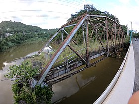 Plata Bridge remains
 -
 What remains of the Plata Bridge from the shore
 -
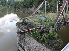 Part of Plata Bridge collapsed


References
- ^ a b "National Register Information System". National Register of Historic Places. National Park Service. March 13, 2009.
- ^ a b Per Google and Bing maps, including their satellite views, accessed May 16, 2016.
- ^ a b Luis Pumarada O'Neill and PRSHPO (July 31, 1994). "Plata Bridge". National Park Service. Retrieved 2016-05-16. with 3 photos from 1993
- ^ Luis F. Pumarada O'Neill (July 31, 1994). "Historic Bridges of Puerto Rico, c. 1840 – 1950". National Park Service. Retrieved 2016-05-13.
External links
 Puerto Rico portal

 Media related to Plata Bridge at Wikimedia Commons
- Summary sheet from the Puerto Rico State Historic Preservation Office (in Spanish)
- v
- t
- e

‡ This historic property also has portions in an adjacent municipality.


