Rajpora
Village in Pulwama, J&K, India
Tehsil in Jammu and Kashmir, India
Rajpora Rajpur | |
|---|---|
Tehsil | |
 Pulwama District | |
| Country |  India India |
| State |  Jammu and Kashmir Jammu and Kashmir |
| Division | Kashmir |
| District | Pulwama |
| Elevation | 1,800 m (5,905 ft) |
| Population | |
| • Total | 5,215[1] |
| Languages | |
| • Official | Kashmiri, Hindi, Urdu, Dogri, English[2][3] |
| Time zone | UTC+5:30 (IST) |
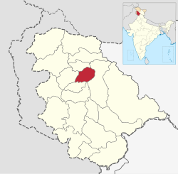
Rajpora, also known as Rajpur, [4] is a Village and a Tehsil in the Pulwama district of the Kashmir Valley of Jammu and Kashmir, India.[5][6] It is located 43 km (27 mi) away from Srinagar and 299 km (186 mi) away from Jammu. Rajpora is situated at 1,800 metres (5,900 ft) above the mean sea level.
Demographics
As per census of 2011 population of Rajpora stands at 5,215, with 2,756 males and 2,459 females.[1] Population of people under the age of 6 in Rajpora is 1,169, which is 22.42% of total population of the village. Average Sex Ratio of Rajpora village is 892 and child Sex Ratio of the Rajpora as per census of 2011 is 729. In 2011, literacy rate of Rajpora was 62% in which male literacy stands at 57.67% while female literacy rate stands at 51.61%.[1]
Villages
1. Gulshanabad 2. Achagoza 3. Bamnoo 4. Pachahar 5. Drabgam 6. Rohmoo 7. Kalampora 8. Shadimarg 9. Sangarwani 10. Thokerpora 11. Mirgund 12. Khaigam 13. Rahmoo 14. Bellow 15. Abhama
Governance
Under the Panchyati Raj Act, Rajpora is administered by the Sarpanch.[1]
Economy
Out of total population only 3,289 people were employed as of 2011 census.[1] Rest of the population is engaged in orchard business. This village has huge dependency on horticulture and other allied sectors like dairy and bread business, a local bread namely Shirmal is world wide famous of this village, exported to other countries like USA ,Australia, UAE ,and other Gulf countries.... [citation needed]
Education
- Government Degree College, Rajpora
- Govt Model Higher Secondary Rajpora
- Govt Girls High School Rajpora
- Abu Hanifa Memorial Institute Rajpora
Castes
Schedule Tribe (ST) constitutes 0.29% of total population in Rajpora. No Scheduled Caste (SC) live in Rajpora.[1]
References
- ^ a b c d e f "Raj Pora Village Population - Pulwama - Pulwama, Jammu and Kashmir". www.census2011.co.in.
- ^ "The Jammu and Kashmir Official Languages Act, 2020" (PDF). The Gazette of India. 27 September 2020. Retrieved 27 September 2020.
- ^ "Parliament passes JK Official Languages Bill, 2020". Rising Kashmir. 23 September 2020. Retrieved 30 May 2021.
- ^ Excelsior, Daily (1 December 2021). "Jaish IED expert, Pakistani terrorist killed in Pulwama: J&K Top Cop". Jammu Kashmir Latest News | Tourism | Breaking News J&K. Retrieved 13 August 2023.
- ^ "About District | Pulwama District, Government of Jammu and Kashmir | India". Retrieved 13 August 2023.
- ^ "Rajpora Pin Code | Postal Code (Zip Code) of Rajpora, Pulwama, Jammu & Kashmir, India". www.indiatvnews.com. Retrieved 13 August 2023.
- v
- t
- e
India topics
History | |||||||||||||||||
|---|---|---|---|---|---|---|---|---|---|---|---|---|---|---|---|---|---|
| |||||||||||||||||
| |||||||||||||||
| |||||||||||||||||
| |||||||||||||||||||||
| |||||
|---|---|---|---|---|---|
| |||||

| ||
|---|---|---|
| Passes |  | |
| Valleys | ||
| Cities | ||
| Towns |
| |
| Rivers | ||
| Glaciers | ||
| Lakes | ||
| Mountains | ||
| Hill stations and Mughal gardens | ||
| Protected areas | ||
| See also |
| |
33°49′27.35″N 74°51′11.29″E / 33.8242639°N 74.8531361°E / 33.8242639; 74.8531361


