Stepenitztal
Municipality in Mecklenburg-Vorpommern, Germany
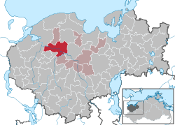
Location of Stepenitztal within Nordwestmecklenburg district
53°52′N 11°05′E / 53.867°N 11.083°E / 53.867; 11.083
(2022-12-31)[1]
23936, 23923
Stepenitztal is a municipality in the Nordwestmecklenburg district, in Mecklenburg-Vorpommern, Germany. It takes its name from the river Stepenitz. It was formed on 25 May 2014 by the merger of the former municipalities Börzow, Mallentin and Papenhusen.
References
- ^ "Bevölkerungsstand der Kreise, Ämter und Gemeinden 2022" (XLS) (in German). Statistisches Amt Mecklenburg-Vorpommern. 2023.
- v
- t
- e
Towns and municipalities in Nordwestmecklenburg
- Alt Meteln
- Bad Kleinen
- Barnekow
- Benz
- Bernstorf
- Bibow
- Blowatz
- Bobitz
- Boiensdorf
- Boltenhagen
- Brüsewitz
- Carlow
- Cramonshagen
- Dalberg-Wendelstorf
- Damshagen
- Dassow
- Dechow
- Dorf Mecklenburg
- Dragun
- Gadebusch
- Gägelow
- Glasin
- Gottesgabe
- Grambow
- Grevesmühlen
- Grieben
- Groß Molzahn
- Groß Stieten
- Hohen Viecheln
- Hohenkirchen
- Holdorf
- Hornstorf
- Insel Poel
- Jesendorf
- Kalkhorst
- Klein Trebbow
- Klütz
- Kneese
- Königsfeld
- Krembz
- Krusenhagen
- Lübberstorf
- Lübow
- Lübstorf
- Lüdersdorf
- Lützow
- Menzendorf
- Metelsdorf
- Mühlen Eichsen
- Neuburg
- Neukloster
- Passee
- Perlin
- Pingelshagen
- Pokrent
- Rehna
- Rieps
- Roduchelstorf
- Roggendorf
- Roggenstorf
- Rögnitz
- Rüting
- Schildetal
- Schlagsdorf
- Schönberg
- Seehof
- Selmsdorf
- Siemz-Niendorf
- Stepenitztal
- Testorf-Steinfort
- Thandorf
- Upahl
- Utecht
- Veelböken
- Ventschow
- Warin
- Warnow
- Wedendorfersee
- Wismar
- Zickhusen
- Zierow
- Zurow
- Züsow

 | This Nordwestmecklenburg location article is a stub. You can help Wikipedia by expanding it. |
- v
- t
- e


