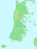
Tarahuín Lake
Lake in Chile
42°42′52.30″S 73°44′11.76″W / 42.7145278°S 73.7366000°W / -42.7145278; -73.7366000Tarahuín Lake (Spanish: Lago Tarahuín) is a lake in south-central Chiloé Island, Chile. It has an area of 7.7 km2.[1] The lake's catchment basin is mostly made up of hilly terrain that is covered by native forest, and to a lesser extent natural prairies.[1]
Chile Route 5 passes bext to the lake's western end.
References
- ^ a b c Villalobos, L., Parra, O., Grandjean, M., Jaque, E., Woelfl, S., Campos, H. (2003). A study of the river basins and limnology of five humic lakes on Chiloé Island. Revista Chilena de Historia Natural, 76 (4), 563–590.
- v
- t
- e
Hydrography of Los Lagos Region
- Bueno
- Contaco
- Corcovado
- Damas
- Gol-Gol
- Futaleufú
- Huellelhue
- Llesquehue
- Llico
- Maullín
- Negro
- Palena
- Petrohué
- Pichi Damas
- Pilmaiquén
- Puelo
- Rahue
- Reñihué
- Yelcho
- Petrohué
- Salto del Indio
- Chaiguata
- Chapo
- Constancia
- Cucao
- Huillinco
- Llanquihue
- Natri
- Palena
- Puyehue
- Reñihue
- Rupanco
- Tarahuín
- Tepuhueico
- Todos los Santos
- Tres Marias
- Yaldad
- Yelcho
 | This Los Lagos Region location article is a stub. You can help Wikipedia by expanding it. |
- v
- t
- e


