Toplița, Hunedoara
Commune in Hunedoara, Romania

Coat of arms

Location in Hunedoara County
(2021-12-01)[1]
337480
Toplița (Hungarian: Királybányatoplica) is a commune in Hunedoara County, Transylvania, Romania. It is composed of eight villages: Curpenii Silvașului, Dăbâca (Doboka), Dealu Mic (Párosza), Goleș (Golles), Hășdău (Hosdó), Mosoru (Moszor), Toplița, and Vălari (Valár).
The commune is located in the central-west part of the county, 18 km (11 mi) southwest of Hunedoara, at the foot of the Poiana Ruscă Mountains. It lies on the banks of the Cerna River and its tributary, the Bunila.
References
- ^ "Populaţia rezidentă după grupa de vârstă, pe județe și municipii, orașe, comune, la 1 decembrie 2021" (XLS). National Institute of Statistics.
-
 Tourism office in Toplița
 -
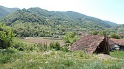 Hășdău


- v
- t
- e
Hunedoara County, Romania
- Băcia
- Baia de Criș
- Băița
- Balșa
- Bănița
- Baru
- Bătrâna
- Beriu
- Blăjeni
- Boșorod
- Brănișca
- Bretea Română
- Buceș
- Bucureșci
- Bulzeștii de Sus
- Bunila
- Burjuc
- Cârjiți
- Cerbăl
- Certeju de Sus
- Crișcior
- Densuș
- Dobra
- General Berthelot
- Ghelari
- Gurasada
- Hărău
- Ilia
- Lăpugiu de Jos
- Lelese
- Lunca Cernii de Jos
- Luncoiu de Jos
- Mărtinești
- Orăștioara de Sus
- Pestișu Mic
- Pui
- Răchitova
- Rapoltu Mare
- Râu de Mori
- Ribița
- Romos
- Sălașu de Sus
- Sântămăria-Orlea
- Sarmizegetusa
- Șoimuș
- Teliucu Inferior
- Tomești
- Toplița
- Totești
- Turdaș
- Vălișoara
- Vața de Jos
- Vețel
- Vorța
- Zam
 | This Hunedoara County location article is a stub. You can help Wikipedia by expanding it. |
- v
- t
- e


