Tvarditsa, Sliven Province
Place in Sliven, Bulgaria
Tvarditsa Твърдица | |
|---|---|
 Overview of Tvarditsa | |
 Coat of arms | |
| 42°42′N 25°54′E / 42.700°N 25.900°E / 42.700; 25.900 | |
| Country | Bulgaria |
| Provinces (Oblast) | Sliven |
| Government | |
| • Mayor | Maria Gvozdeikova |
| Elevation | 396 m (1,299 ft) |
| Population (2018-12-31)[1] | |
| • Total | 5,659 |
| Time zone | UTC+2 (EET) |
| • Summer (DST) | UTC+3 (EEST) |
| Postal Code | 8890 |
| Area code | 0454 |
| License plate | CH |
Tvarditsa (Bulgarian: Твърдица [tvɐrˈdit͡sɐ]) is a town in Sliven Province, Southeastern Bulgaria. It is the administrative centre of the homonymous Tvarditsa Municipality. As of December 2018, the town has a population of 5,659 inhabitants.[1]
Tvarditsa is located in the Tvarditsa Valley on the southern slopes of Stara Planina. The area around is known as the Tvarditsa Coal Basin, the only place in the country where soft coal is mined.
Tvarditsa Rocks in the South Shetland Islands, Antarctica are named after Tvarditsa.[2] The Bessarabian Bulgarian village of Tvardiţa in Taraclia District, Moldova, was founded by refugees from Tvardisa, who named it after their ancestral town.[3]
Population
As of December 2018, the town of Tvarditsa has 5,659 inhabitants, while the municipality of Tvarditsa has 13,413 inhabitants. Most inhabitants are ethnic Bulgarians (89%), followed by a large Romani minority (9%). The main faith is Orthodox Christianity.

Wikimedia Commons has media related to Tvarditsa.
Gallery
-
 Main square and city hall
 -
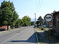 The main road to the Balkan pass
 -
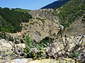 Balkan mountains
 -
 Entrance to the Church of Saint Petka


Notes
- v
- t
- e

- Sofia (capital)

- Balchik
- Bankya
- Berkovitsa
- Byala Slatina
- Cherven Bryag
- Chirpan
- Elhovo
- Etropole
- Gotse Delchev
- Harmanli
- Ihtiman
- Karnobat
- Kavarna
- Knezha
- Kostinbrod
- Kozloduy
- Mezdra
- Nesebar
- Novi Iskar
- Novi Pazar
- Panagyurishte
- Parvomay
- Pavlikeni
- Peshtera
- Pomorie
- Popovo
- Provadia
- Radnevo
- Radomir
- Rakovski
- Razlog
- Stamboliyski
- Svilengrad
- Aksakovo
- Bansko
- Belene
- Belogradchik
- Beloslav
- Bobov Dol
- Bozhurishte
- Byala, Ruse Province
- Chepelare
- Devin
- Devnya
- Dolni Chiflik
- Dryanovo
- Dulovo
- Elena
- Elin Pelin
- Galabovo
- General Toshevo
- Hisarya
- Isperih
- Kostenets
- Kotel
- Krichim
- Krumovgrad
- Kubrat
- Kuklen
- Levski
- Lukovit
- Lyaskovets
- Lyubimets
- Madan
- Momchilgrad
- Omurtag
- Oryahovo
- Perushtitsa
- Pirdop
- Rakitovo
- Saedinenie
- Septemvri
- Simeonovgrad
- Simitli
- Slivnitsa
- Sopot, Plovdiv Province
- Sredets
- Straldzha
- Svoge
- Tervel
- Teteven
- Topolovgrad
- Tryavna
- Tsarevo
- Tutrakan
- Tvarditsa
- Varshets
- Veliki Preslav
- Yakoruda
- Zlatitsa
- Zlatograd
- Aheloy
- Apriltsi
- Ardino
- Banya
- Batak
- Batanovtsi
- Belitsa
- Belovo
- Borovo
- Bratsigovo
- Bregovo
- Breznik
- Byala
- Chernomorets
- Dalgopol
- Debelets
- Dobrinishte
- Dolna Banya
- Dolna Mitropoliya
- Dolna Oryahovitsa
- Dolni Dabnik
- Dospat
- Dragoman
- Dunavtsi
- Dve Mogili
- Dzhebel
- Glodzhevo
- Godech
- Gulyantsi
- Gurkovo
- Hadzhidimovo
- Ignatievo*
- Iskar
- Ivaylovgrad
- Kableshkovo
- Kalofer
- Kameno
- Kaspichan
- Kilifarevo
- Klisura
- Kocherinovo
- Koprivshtitsa
- Kostandovo
- Koynare
- Kresna
- Kran
- Krivodol
- Kula
- Laki
- Letnitsa
- Loznitsa
- Maglizh
- Malko Tarnovo
- Marten
- Мizia
- Nedelino
- Nikolaevo
- Nikopol
- Obzor
- Opaka
- Pavel Banya
- Polski Trambesh
- Pordim
- Pravets
- Primorsko
- Rila
- Roman
- Rudozem
- Sadovo
- Sapareva Banya
- Sarnitsa
- Shabla
- Shivachevo
- Slavyanovo
- Slivo Pole
- Smyadovo
- Sozopol
- Strazhitsa
- Strelcha
- Sungurlare
- Suvorovo
- Sveti Vlas
- Tran
- Trastenik
- Tsar Kaloyan
- Ugarchin
- Valchedram
- Valchi Dol
- Varbitsa
- Vetovo
- Vetren
- Yablanitsa
- Zavet
- Zlataritsa
- city status after the census of 01.02.2011: Ignatievo, Kran
Authority control databases | |
|---|---|
| International |
|
| National |
|
42°42′N 25°54′E / 42.700°N 25.900°E / 42.700; 25.900


