Ubachsberg
Village in Limburg, Netherlands
50°51′10″N 5°56′50″E / 50.85278°N 5.94722°E / 50.85278; 5.94722 (2021)[1]
6367[1]
Ubachsberg (Dutch pronunciation: [ˈybɑɣzbɛr(ə)x]) is a village in the Dutch province of Limburg. It is located in the municipality of Voerendaal.[3]
The village was first mentioned in 1380 as "opten Berch", and means "hill of the Ubachs family".[4] Ubachsberg developed in the Early Middle Ages on the road from Simpelveld to Sittard.[5]
The Catholic St Bernardus Church is a neoclassic cruciform church built in 1842.[5]
Restaurant De Leuf (2 Michelin stars) is located in the village.[6]
-
 Chapel in the "Oude Schoolstraat"
 -
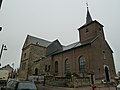 Sint-Bernarduskerk
 -
 Maria statue Hunsstraat
 -
 Limekiln


References
- ^ a b c "Kerncijfers wijken en buurten 2021". Central Bureau of Statistics. Retrieved 26 April 2022.
- ^ "Postcodetool for 6367AA". Actueel Hoogtebestand Nederland (in Dutch). Het Waterschapshuis. Retrieved 26 April 2022.
- ^ ANWB Topografische Atlas Nederland, Topografische Dienst and ANWB, 2005.
- ^ "Ubachsberg - (geografische naam)". Etymologiebank (in Dutch). Retrieved 26 April 2022.
- ^ a b Sabine Broekhoven, & Ronald Stenvert (2003). Ubachsberg (in Dutch). Zwolle: Waanders. ISBN 90 400 9623 6. Retrieved 26 April 2022.
- ^ (in Dutch) De Leuf
- v
- t
- e


