Upper Camster
Human settlement in Scotland
- Highland
Upper Camster is a small hamlet, which lies at the source of the Camster Burn, 4 miles north of Lybster, in Caithness, Scottish Highlands and is in the Scottish council area of Highland.[1]
The Grey Cairns of Camster are two large Neolithic chambered cairns located about quarter of a mile north of Upper Camster. The cairns, which are considered to be examples of the Orkney-Cromarty type of chambered cairn, were constructed in the third or fourth millennium BC in a desolate stretch of boggy peat-covered moorland in the Flow Country of Caithness.[2]
Gallery
-
 Camster Long Cairn, Upper Camster
 -
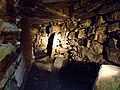 Burial chamber inside Camster Long.
 -
 Camster Cairns.
 -
 The Grey Cairns of Camster. These cairns are open to the public.
 -
 Grey Cairns of Camster, Caithness, Scotland - Camster Long Cairn, exterior
 -
 Remote road in the flow country


References
- v
- t
- e


