Vaghuhas
Place
Vaghuhas Վաղուհաս | ||
|---|---|---|
| Qozlu | ||
 | ||
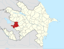
| Coordinates: |  Azerbaijan Azerbaijan | |
| • District | Kalbajar | |
| Elevation | 988 m (3,241 ft) | |
| Population (2015)[1] | ||
| • Total | 678 | |
| Time zone | UTC+4 (AZT) | |
Vaghuhas (Armenian: Վաղուհաս) or Gozlu (Azerbaijani: Qozlu) is a village located in the Kalbajar District of Azerbaijan, in the disputed region of Nagorno-Karabakh. The village has an ethnic Armenian-majority population, and also had an Armenian majority in 1989.[2]
History
During the Soviet period, the village was a part of the Mardakert District of the Nagorno-Karabakh Autonomous Oblast.
According to civilian reports, during the 2023 Azerbaijani offensive in Nagorno-Karabakh, Azerbaijani soldiers entered the village and forcibly demanded that its entire Armenian population leave while firing their weapons in the air.[3][4]
Historical heritage sites
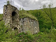
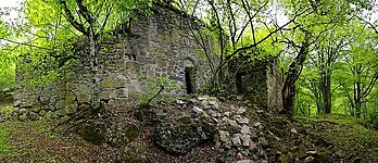
Historical heritage sites in and around the village include the ruins of the ancient Armenian settlement of Mayrakahag (Armenian: Մայրաքաղաք), including the Tiramayr Monastery (Armenian: Տիրամայր Վանք) built in 1183,[5] an 8th/9th-century chapel, a 12th/13th-century cemetery, the monastery of Khatravank (Armenian: Խաթրավանք) built in 1204, the monastery of Karmiravan (Armenian: Կարմիրավան) built in 1224, also known as the Red Monastery – Karmir Vank, Կարմիր վանք, and the medieval village of Hin Vaghuhas (Armenian: Հին Վաղուհաս, lit. 'Old Vaghuhas').[1]
Economy and culture
The population is mainly engaged in agriculture and animal husbandry. As of 2015, the village has a municipal building, a house of culture, a secondary school, seven shops, and a medical centre.[1]
Demographics
The village had 638 inhabitants in 2005,[6] and 678 inhabitants in 2015.[1]
Gallery
-
 Scenery around Vaghuhas
 -
 Forest near the village
 -
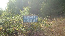 A sign in Armenian reading "Vaghuhas"
 -
 Khachkars of Khatravank
 -
 Forest near the village
 -
 Aerial view of Vaghuhas
 -
 Interior of Khatravank
 -
 The 13th-century Karmiravan Monastery
 -
 Inscriptions in Armenian on the walls of the Karmiravan Monastery


References
- ^ a b c d Hakob Ghahramanyan. "Directory of socio-economic characteristics of NKR administrative-territorial units (2015)".
- ^ Андрей Зубов. "Андрей Зубов. Карабах: Мир и Война". drugoivzgliad.com.
- ^ Hauer, Neil (September 29, 2023). "Tragedy in real time: The Armenian exodus from Nagorno-Karabakh". Canada: CTV News.
- ^ Grigoryan, Rima; Makiyan, Hayk (September 27, 2023). "Stranded in Goris: Karabakh Family Sleeps in Van". Armenia: Hetq.
- ^ Ш. Мкртчян / Майракахак или монастырь Тирамайр /Историко-архитектурные памятники Нагорно-Карабаха/ стр. 47-48 (360)
- ^ "The Results of the 2005 Census of the Nagorno-Karabakh Republic" (PDF). National Statistic Service of the Republic of Artsakh.
External links
Wikimedia Commons has media related to Qozlu.
- Vaghuhas at GEOnet Names Server
- v
- t
- e
Capital: Martakert

- Aghabekalanj
- Arajadzor
- Chankatagh
- Chapar
- Chldran
- Drmbon
- Garnakar
- Ghazarahogh
- Getavan
- Harutyunagomer
- Haterk
- Imar
- Jraberd
- Khnkavan
- Kichan
- Kmkadzor
- Kochoghot
- Kolatak
- Kusapat
- Maghavuz
- Mehmana
- Mets Shen
- Mokhratagh
- Nareshtar
- Nerkin Horatagh
- Nor Ghazanchi
- Poghosagomer
- Seysulan
- Shahmasur
- Tblghu
- Tonashen
- Tsaghkashen
- Tsmakahogh
- Vaghuhas
- Vank
- Vardadzor
- Varnkatagh
- Verin Horatagh
- Zaglik
- Zardakhach
Portal:
 Geography


