West Boulevard
Neighborhood of Cleveland, Ohio, United States
Neighborhood of Cleveland in Cuyahoga County, Ohio, United States
West Boulevard | |
|---|---|
Neighborhood of Cleveland | |
 Lorain Station Historic District in West Boulevard | |
 | |
| Country | United States |
| State | Ohio |
| County | Cuyahoga County |
| City | Cleveland |
| Population (2020)[1] | |
| • Total | 19,737 |
| Demographics[1] | |
| • White | 55.5% |
| • Black | 23.8% |
| • Hispanic (of any race) | 27.5% |
| • Asian and Pacific Islander | 3.2% |
| • Mixed and Other | 17.5% |
| Time zone | UTC-5 (EST) |
| • Summer (DST) | UTC-4 (EDT) |
| Area code | 216 |
| Median income[1] | $33,784 |
| Source: 2020 U.S. Census | |
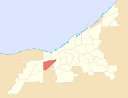
West Boulevard is a neighborhood on the West Side of Cleveland, Ohio. It borders the suburbs of Brooklyn and Linndale to the south, Interstate 90 and the neighborhoods of Cudell and Detroit–Shoreway to the north, Stockyards to the east, and Jefferson to the west.[2] Its name is derived "from the West Blvd. thoroughfare which runs north-south through the district’s center."[3]
The principal portion of the neighborhood was incorporated into Cleveland in 1902 as part of Linndale. One year later, Cleveland annexed the majority of the land as what is now known as the West Boulevard neighborhood.[3]
West Boulevard has been historically home to a mixed population of Hungarians, Czechs, and Germans,[3] and in recent years, it has also been home to a growing Hispanic community.[1] As of 2019, the neighborhood had an estimated foreign-born population of 18.5%, with most being immigrants from Latin America (especially El Salvador and Mexico) and Vietnam.[4]
Notable neighborhood attractions include the St. Ignatius of Antioch Catholic Church, completed in 1903,[5] and Ray's MTB Indoor Park, the world's first multi-terrain indoor bike park.
References
- ^ a b c d "Cleveland Neighborhoods and Wards: West Boulevard Neighborhood Factsheet (2021)" (PDF). The Center for Community Solutions (Cleveland). Retrieved June 3, 2022.
- ^ "Map of West Boulevard, Implemented by the City of Cleveland in 2012" (PDF). Northern Ohio Data and Information Service (NODIS), Levin College of Urban Affairs (Cleveland State University). Retrieved July 23, 2022.
- ^ a b c Roy, Christopher (24 August 2020). "West Boulevard Neighborhood". The Encyclopedia of Cleveland History. Case Western Reserve University. Retrieved June 25, 2021.
- ^ "National Origins in West Boulevard, Cleveland, Ohio (Neighborhood)". Statistical Atlas. Retrieved July 23, 2022.
- ^ "1. Early History - Saint Ignatius of Antioch".
- v
- t
- e

| Local | |
|---|---|
| State | |
| Federal |
| Land | |
|---|---|
| Air | |
| Water |
| Historic places |
|
|---|---|
| Museums |
|
| Parks and nature | |
| Performing arts | |
| Sports, concert, and convention venues | |
| Traditions |
- Broadway–Slavic Village
- Brooklyn Centre
- Buckeye–Shaker
- Buckeye–Woodhill
- Central
- Clark–Fulton
- Collinwood
- Cudell
- Cuyahoga Valley
- The Flats
- Whiskey Island
- Detroit–Shoreway
- Downtown
- Campus District
- Civic Center
- East 4th Street
- Gateway District
- Nine-Twelve District
- North Coast Harbor
- Short Vincent
- Superior Arts District
- Warehouse District
- Edgewater
- Euclid–Green
- Fairfax
- Glenville
- Goodrich–Kirtland Park
- Hough
- Kinsman
- Lee–Miles
- Mount Pleasant
- Ohio City
- Old Brooklyn
- St. Clair–Superior
- Stockyards
- Tremont
- Union–Miles Park
- University Circle
- West Boulevard
- West Park
| Major league |
|
|---|---|
| Minor League |
|
| College |
|
Places adjacent to West Boulevard | ||||||||||||||||
|---|---|---|---|---|---|---|---|---|---|---|---|---|---|---|---|---|
| ||||||||||||||||


41°27′32″N 81°45′18″W / 41.459°N 81.755°W / 41.459; -81.755
 | This Cuyahoga County, Ohio state location article is a stub. You can help Wikipedia by expanding it. |
- v
- t
- e


