Wicklewood
Human settlement in England
- Wicklewood
- South Norfolk
- Norfolk
- East
- Mid Norfolk
Wicklewood is a village and civil parish in the South Norfolk district of Norfolk, England. It is located 11 miles (18 km) west of Norwich next to the market town of Wymondham, neighbouring the villages of Deopham, Hackford and Kimberley. It covers an area of 8.75 km2 (3.38 sq mi) and had a population of 886 in 345 households at the 2001 census,[1] which had increased to 922 at the 2011 Census.[2]
The villages name probably means, 'wych-elm wood/clearing'. 'Wood' is redundant.[3]
Governance
An electoral ward in the same name exists. This ward has a population of 3,308 at the 2011 Census.[4]
Amenities
The village has a small primary school, Wicklewood School, as well as a small church, St Andrews and All Saints.
Wicklewood has a local cricket team that participates in various Sunday League matches and was the holder of the Wicklewood Shield trophy won in 2006.[citation needed]
The village also has one public house called the Cherry Tree where the full range of Buffy's ales, made in Tivetshall St. Mary, can be tasted.
Hospital Road is the site of a large neo-Georgian building, now private homes. This is the former Forehoe workhouse, built in the late 19th century. In 1948 it was incorporated into the National Health Service as Hill House Hospital, later Wicklewood Geriatric Hospital, before closing in 1974.[5]
The former Ashcroft supported housing centre on Milestone Lane has been closed since 2015:[6] as of 2019, the buildings are for sale to be redeveloped as private housing.[7]
The former St James Church on Low Street served the community of Crownthorpe. Its patron was Lord Wodehouse.[8] It is now a private residence.[9]
Roman remains
The site of a Romano-Celtic temple near Wicklewood was discovered from cropmarks in 1959, and was excavated in that year. It evidently served a settlement nearby, as many Roman objects have been found.[10]
- Wicklewood Gallery
-
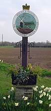 Signpost in Wicklewood
 -
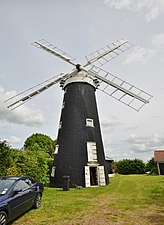 Wicklewood Mill
 -
 The inside of the mill
 -
 St Andrews and All Saints Church
 -
 A close up of the church


References
- ^ "Wicklewood parish information". South Norfolk Council. 20 May 2009. Retrieved 20 June 2009.
- ^ "Parish population 2011". Retrieved 10 September 2015.
- ^ "Key to English Place-names".
- ^ "Ward population 2011". Retrieved 10 September 2015.
- ^ "Forehoe, Norfolk". The Workhouse history of an institution.
- ^ "A Vital Mental Health Service in Norfolk Due to Close as a Result of Insufficient Funding". Julian Support.
- ^ "Detached house for sale in Milestone Lane, Wicklewood, Wymondham NR18". Primelocation.
- ^ "Crowfield - Croydon Pages 737-742 A Topographical Dictionary of England". British History Online. S Lewis, London 1848. Retrieved 19 November 2023.
- ^ "St James, Crownthorpe". Norfolk Churches. Retrieved 19 November 2023.
- ^ Historic England. "Romano-Celtic temple 590m south east of St James's Church (1020862)". National Heritage List for England. Retrieved 26 September 2023.
External links
Wikimedia Commons has media related to Wicklewood.
- Wicklewood Archive
- The Cherry Tree
- Buffy's Brewery
- Wicklewood home page
- Wicklewood Parish Council
- Wicklewood School
- v
- t
- e
- Alburgh
- Aldeby
- Alpington
- Ashby St Mary
- Ashwellthorpe and Fundenhall
- Aslacton
- Barford
- Barnham Broom
- Bawburgh
- Bedingham
- Bergh Apton
- Bracon Ash
- Bramerton
- Brandon Parva, Coston, Runhall and Welborne
- Bressingham
- Brockdish
- Brooke
- Broome
- Bunwell
- Burgh St Peter
- Burston and Shimpling
- Caistor St Edmund and Bixley
- Carleton Rode
- Carleton St Peter
- Chedgrave
- Claxton
- Colney
- Costessey
- Cringleford
- Denton
- Deopham
- Dickleburgh and Rushall
- Diss
- Ditchingham
- Earsham
- East Carleton
- Easton
- Ellingham
- Flordon
- Forncett
- Framingham Earl
- Framingham Pigot
- Geldeston
- Gillingham
- Gissing
- Great Melton
- Great Moulton
- Haddiscoe
- Hales
- Heckingham
- Hedenham
- Hellington
- Hempnall
- Heywood
- Hethersett
- Hingham
- Holverston
- Howe
- Keswick and Intwood
- Ketteringham
- Kimberley
- Kirby Bedon
- Kirby Cane
- Kirstead
- Langley with Hardley
- Little Melton
- Loddon
- Long Stratton
- Marlingford and Colton
- Morley
- Morningthorpe and Fritton
- Mulbarton
- Mundham
- Needham
- Newton Flotman
- Norton Subcourse
- Poringland
- Pulham Market
- Pulham St Mary
- Raveningham
- Redenhall with Harleston
- Rockland St Mary
- Roydon
- Saxlingham Nethergate
- Scole
- Seething
- Shelfanger
- Shelton and Hardwick
- Shotesham
- Sisland
- Spooner Row
- Starston
- Stockton
- Stoke Holy Cross
- Surlingham
- Swainsthorpe
- Swardeston
- Tacolneston
- Tasburgh
- Tharston and Hapton
- Thurlton
- Thurton
- Thwaite
- Tibenham
- Tivetshall
- Toft Monks
- Topcroft
- Trowse
- Wacton
- Wheatacre
- Wicklewood
- Winfarthing
- Woodton
- Wortwell
- Wramplingham
- Wreningham
- Wymondham
- Yelverton
 | This Norfolk location article is a stub. You can help Wikipedia by expanding it. |
- v
- t
- e


