District de Bruck an der Leitha

Cet article est une ébauche concernant l’Autriche.
Vous pouvez partager vos connaissances en l’améliorant (comment ?) selon les recommandations des projets correspondants.
| Bruck an der Leitha | |||
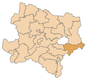 Localisation du district de Bruck an der Leitha dans le Land autrichien de Basse-Autriche. | |||
| Administration | |||
|---|---|---|---|
| Pays |  Autriche Autriche | ||
| Land |  Basse-Autriche Basse-Autriche | ||
| Centre administratif | Bruck an der Leitha | ||
| Immatriculation | BL | ||
| Démographie | |||
| Population | 44 969 hab. ([1]) | ||
| Densité | 64 hab./km2 | ||
| Géographie | |||
| Coordonnées | 48° 01′ 45″ nord, 16° 46′ 44″ est | ||
| Superficie | 70 322 ha = 703,22 km2 | ||
| Localisation | |||
| Géolocalisation sur la carte : Autriche
Géolocalisation sur la carte : Autriche
| |||
modifier  | |||


Le district de Bruck an der Leitha est une subdivision territoriale du Land de Basse-Autriche en Autriche.
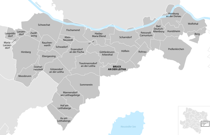
Communes
Le district de Bruck an der Leitha est subdivisé en 33 communes :
- Au am Leithaberge
- Bad Deutsch-Altenburg
- Berg
- Bruck an der Leitha
- Ebergassing
- Enzersdorf an der Fischa
- Fischamend
- Göttlesbrunn-Arbesthal
- Götzendorf an der Leitha
- Gramatneusiedl
- Hainburg an der Donau
- Haslau-Maria Ellend
- Himberg
- Hof am Leithaberge
- Höflein
- Hundsheim
- Klein-Neusiedl
- Lanzendorf
- Leopoldsdorf
- Mannersdorf am Leithagebirge
- Maria Lanzendorf
- Moosbrunn
- Petronell-Carnuntum
- Prellenkirchen
- Rauchenwarth
- Rohrau
- Scharndorf
- Schwadorf
- Schwechat
- Sommerein
- Trautmannsdorf an der Leitha
- Wolfsthal
- Zwölfaxing
Carte interactive des communes du district de Bruck an der Leitha

Les subdivisions administratives.

v · m | ||
|---|---|---|
| Les 21 districts (Bezirke) et les 4 villes à statut (Statutarstädte) de la Basse-Autriche, en Autriche | ||
| Villes à statut |  | |
| Districts |
| |
 Portail de l'Autriche

- ↑ « http://www.statistik.at/wcm/idc/idcplg?IdcService=GET_NATIVE_FILE&RevisionSelectionMethod=LatestReleased&dDocName=080904 » (consulté le )
- ↑ a b et c Bevölkerung zu Jahresbeginn nach Gemeinden seit 2002, (statistique publique), Statistik Austria, , [lire en ligne]

- ↑ a b c d e f g h i j k l m n o p q r s t u v w x y z aa ab ac et ad « Einwohnerzahl 1.1.2018 nach Gemeinden mit Status, Gebietsstand 1.1.2018 », Statistik Austria (en) (consulté le )


