Ribble Valley
Niet-metropolitaans district in Engeland  | |||
|---|---|---|---|
  | |||
| Situering | |||
| Land | Engeland | ||
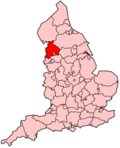
| County | Lancashire | ||
| Regio | North West England | ||
| Coördinaten | 53°53'NB, 2°24'WL | ||
| Algemeen | |||
| Oppervlakte | 583,1857[1] km² | ||
| Inwoners (2018[2]) | 60.057 (103 inw./km²) | ||
| ONS-code | E07000124 | ||
| Detailkaart | |||
 | |||
| |||

Ribble Valley is een Engels district erkend als borough in het shire-graafschap (non-metropolitan county OF county) Lancashire en telt 60.000 inwoners. De oppervlakte bedraagt 584 km².
Van de bevolking is 20.2% ouder dan 65 jaar. De werkloosheid bedraagt 2,1% van de beroepsbevolking (cijfers volkstelling 2011).[3]
Civil parishes in district Ribble Valley
Aighton, Bailey and Chaigley, Balderstone, Bashall Eaves, Billington and Langho, Bolton-by-Bowland, Bowland Forest High, Bowland Forest Low, Bowland-with-Leagram, Chatburn, Chipping, Clayton-le-Dale, Clitheroe, Dinckley, Downham, Dutton, Easington, Gisburn, Gisburn Forest, Great Mitton, Grindleton, Horton, Hothersall, Little Mitton, Longridge, Mearley, Mellor, Middop, Newsholme, Newton, Osbaldeston, Paythorne, Pendleton, Ramsgreave, Read, Ribchester, Rimington, Sabden, Salesbury, Sawley, Simonstone, Slaidburn, Thornley-with-Wheatley, Twiston, Waddington, West Bradford, Whalley, Wilpshire, Wiswell, Worston.
Bronnen, noten en/of referenties
|


