Bonyhádvarasd
Village in Southern Transdanubia, Hungary

Coat of arms
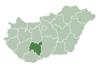
 Hungary
 (2022)[1]
7158
Bonyhádvarasd is a village in Tolna County, Hungary.[2]
References
- ^ a b c "Bonyhádvarasd". Detailed Gazetteer of Hungary. Hungarian Central Statistical Office. Retrieved 2024-01-13.
- ^ "MAGYARORSZÁG HELYSÉGNÉVTÁRA, 2012". ksh.hu. Retrieved 23 October 2015.
46°22′N 18°29′E / 46.367°N 18.483°E / 46.367; 18.483

| ||
|---|---|---|
| City with county rights |
|   |
| Towns | ||
| Large villages | ||
| Villages |
| |
| Other topics |
| |
| Authority control databases |
|
|---|
 | This Tolna location article is a stub. You can help Wikipedia by expanding it. |
- v
- t
- e


