List of bridges on the National Register of Historic Places in Puerto Rico
Bridges in Puerto Rico listed on the US National Register of Historic Places
This is a list of bridges and tunnels on the National Register of Historic Places in the U.S. territory of Puerto Rico.[1]
| Name | Image | Built | Listed | Location | Type |
|---|---|---|---|---|---|
| Arenas Bridge |  | 1894 | 1995-07-19 | Cayey 18°8′11″N 66°8′18″W / 18.13639°N 66.13833°W / 18.13639; -66.13833 (Arenas Bridge) | Metal truss |
| Blanco Bridge | 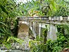 | 1924 | 1995-07-19 | Utuado | Elliptical concrete arch |
| Bridge No. 122 |  | 1918 | 1995-07-19 | Naguabo 18°11′16″N 65°43′48″W / 18.18778°N 65.73000°W / 18.18778; -65.73000 (Bridge No. 122) | |
| Cambalache Bridge | 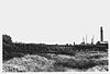 | 1893 | 1995-07-19 | Arecibo 18°27′20″N 66°42′9″W / 18.45556°N 66.70250°W / 18.45556; -66.70250 (Cambalache Bridge) | Double intersection Pratt truss |
| Cayey Bridge | 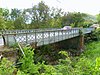 | 1891 | 1995-07-19 | Guayama 18°0′9″N 66°6′55″W / 18.00250°N 66.11528°W / 18.00250; -66.11528 (Cayey Bridge) | Iron lateral lattice girder |
| Del Treinta Bridge | 1924 | 1995-07-19 | Maricao | Rolled steel beam | |
| General Méndez Vigo Bridge | 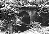 | 1898 | 1995-07-19 | Coamo | Brick barrel vault |
| General Norzagaray Bridge |  | 1855, 1927 | 1995-07-19 | San Juan 18°21′14″N 66°5′31″W / 18.35389°N 66.09194°W / 18.35389; -66.09194 (General Norzagaray Bridge) | Brick barrel vault |
| La Liendre Bridge |  | 1877 | 1995-07-19 | Cayey 18°8′11″N 66°7′52″W / 18.13639°N 66.13111°W / 18.13639; -66.13111 (La Liendre Bridge) | Iron lattice lateral girder |
| Las Cabañas Bridge |  | 1919 | 1995-07-19 | Adjuntas | |
| Manatí Bridge at Mata de Plátano | 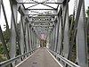 | 1905 | 1995-07-19 | Ciales 18°21′39″N 66°28′45″W / 18.36083°N 66.47917°W / 18.36083; -66.47917 (Manatí Bridge at Mata de Plátano) | Double intersection Pratt truss |
| Marqués de la Serna Bridge |  | 1869, 1881, 1889 | 1995-07-19 | Bayamón 18°24′17″N 66°9′21″W / 18.40472°N 66.15583°W / 18.40472; -66.15583 (Marques de la Serna Bridge) | Rolled iron segmented arch |
| Martín Peña Bridge | 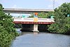 | 1939 | 2008-8-27 | San Juan 18°24′17″N 66°9′21″W / 18.40472°N 66.15583°W / 18.40472; -66.15583 (Marques de la Serna Bridge) | Art Deco style bridge |
| Mavilla Bridge | 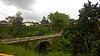 | 1903, 1909 | 1995-07-19 | Corozal | Segmented arch |
| Padre Íñigo Bridge | 1853 | 1995-07-19 | Coamo | Brick barrel vault | |
| Plata Bridge | 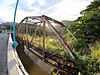 | 1908 | 1995-07-19 | Naranjito 18°18′14″N 66°12′41″W / 18.30384°N 66.21132°W / 18.30384; -66.21132 (Plata Bridge) | Two Parker truss spans |
| Puente de Añasco | 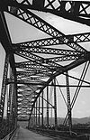 | 2011-1-18 | Añasco vicinity | ||
| Puente Blanco |  | 1922 | 1984-2-23 | Quebradillas 18°29′17″N 66°55′35″W / 18.48806°N 66.92639°W / 18.48806; -66.92639 (Puente Blanco) | Arch |
| Puente de las Calabazas |  | 1882 | 2009-2-17 | Coamo | Lattice girder |
| Puente No. 6 | 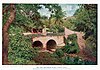 | 1984-2-23 | Caguas vicinity 18°17′9″N 66°2′35″W / 18.28583°N 66.04306°W / 18.28583; -66.04306 (Puente No. 6) | ||
| Puente Río Portugués |  | 1933 | 2015-01-06 | Ponce 17°59′36.2″N 66°36′55.08″W / 17.993389°N 66.6153000°W / 17.993389; -66.6153000 (Puente Río Portugués) | Art Deco/longitudinal beam |
| Río Hondo Bridge |  | 1908 | 1995-07-19 | Comerío 18°12′39″N 66°14′36″W / 18.21083°N 66.24333°W / 18.21083; -66.24333 (Río Hondo Bridge) | Double Warren pony truss |
| Río Matón Bridge | 1886 | 1995-07-19 | Cayey 18°8′30″N 66°12′43″W / 18.14167°N 66.21194°W / 18.14167; -66.21194 (Rio Matón Bridge) | Lateral solid web girder | |
| Río Piedras Bridge | 1853 | 1995-07-19 | San Juan 18°23′49″N 66°3′21″W / 18.39694°N 66.05583°W / 18.39694; -66.05583 (Rio Piedras Bridge) | Brick barrel vault | |
| San Antonio Railroad Bridge | 2009-9-30 | San Juan vicinity 18°23′49″N 66°3′21″W / 18.39694°N 66.05583°W / 18.39694; -66.05583 (Rio Piedras Bridge) | |||
| Silva Bridge |  | 1897, 1898 | 1995-07-19 | Hormigueros | Pratt pony truss |
| Torréns Bridge | 1878, 1898 | 2000-05-11 | Hormigueros | lattice, transverse joist | |
| Villarán Bridge | 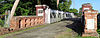 | 1892 | 1995-07-19 | Canóvanas 18°22′52″N 65°53′33″W / 18.38111°N 65.89250°W / 18.38111; -65.89250 (Villarán Bridge) |
References
Map all coordinates using OpenStreetMap
Download coordinates as:
- KML
- GPX (all coordinates)
- GPX (primary coordinates)
- GPX (secondary coordinates)
- ^ "National Register Information System". National Register of Historic Places. National Park Service. July 9, 2010.
- v
- t
- e
- Alabama
- Alaska
- Arizona
- Arkansas
- California
- Colorado
- Connecticut
- Delaware
- Florida
- Georgia
- Guam
- Hawaii
- Idaho
- Illinois
- Indiana
- Iowa
- Kansas
- Kentucky
- Louisiana
- Maine
- Maryland
- Massachusetts
- Michigan
- Minnesota
- Mississippi
- Missouri
- Montana
- Nebraska
- Nevada
- New Hampshire
- New Jersey
- New Mexico
- New York
- North Carolina
- North Dakota
- Ohio
- Oklahoma
- Oregon
- Pennsylvania
- Puerto Rico
- Rhode Island
- South Carolina
- South Dakota
- Tennessee
- Texas
- Utah
- Vermont
- Virginia
- Washington
- Washington, D.C.
- West Virginia
- Wisconsin
- Wyoming
Portals:
 Puerto Rico
 National Register of Historic Places
 Transport
 Engineering


