Massachusetts statistical areas
Massachusetts statistical areas
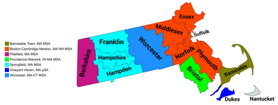
The United States Commonwealth of Massachusetts currently has eight statistical areas that have been delineated by the Office of Management and Budget (OMB). On July 21, 2023, the OMB delineated two combined statistical area, seven metropolitan statistical areas, and three micropolitan statistical area in Massachusetts.[1]
Statistical areas
The Office of Management and Budget (OMB) has designated more than 1,000 statistical areas for the United States and Puerto Rico.[2] These statistical areas are important geographic delineations of population clusters used by the OMB, the United States Census Bureau, planning organizations, and federal, state, and local government entities.
The OMB defines a core-based statistical area (commonly referred to as a CBSA) as "a statistical geographic entity consisting of the county or counties (or county-equivalents) associated with at least one core[a] of at least 10,000 population, plus adjacent counties having a high degree of social and economic integration with the core as measured through commuting ties with the counties containing the core."[2] The OMB further divides core-based statistical areas into metropolitan statistical areas (MSAs) that have "a population of at least 50,000" and micropolitan statistical areas (μSAs) that have "a population of at least 10,000, but less than 50,000."[2]
The OMB defines a combined statistical area (CSA) as "a geographic entity consisting of two or more adjacent core-based statistical areas with employment interchange measures[b] of at least 15%."[2] The primary statistical areas (PSAs) include all combined statistical areas and any core-based statistical area that is not a constituent of a combined statistical area.
Table
The table below describes the 10 United States statistical areas and 14 counties of the Commonwealth of Massachusetts with the following information:[3]
- The combined statistical area (CSA) as designated by the OMB.[1]
- The CSA population according to 2022 US Census Bureau population estimates.[4]
- The core based statistical area (CBSA)[2] as designated by the OMB.[1]
- The CBSA population according to 2022 US Census Bureau population estimates [4]
- The Metropolitan Division name, if applicable[1]
- The county name
- The Metropolitan Division population according to 2022 US Census Bureau population estimates [4]
- The county population according to 2022 US Census Bureau population estimates [4]
- The county population in 2020 according to 2022 US Census Bureau population estimates [4]
| Combined Statistical Area | 2022 Population | Core Based Statistical Area | 2022 Population | County | 2022 Population | 2020 Population | ||
|---|---|---|---|---|---|---|---|---|
| Boston-Worcester-Providence, MA-RI-NH-CT CSA | 8,313,653 6,124,303 | Boston-Cambridge-Newton, MA-NH MSA | 4,900,550 4,448,851 | Cambridge-Newton-Framingham, MA MD | Middlesex County, Massachusetts | 2,423,870 | 1,617,105 | 1,628,671 |
| Essex County, Massachusetts | 806,765 | 808,491 | ||||||
| Boston, MA MD | Suffolk County, Massachusetts | 2,024,981 | 766,381 | 793,271 | ||||
| Norfolk County, Massachusetts | 725,531 | 724,322 | ||||||
| Plymouth County, Massachusetts | 533,069 | 530,154 | ||||||
| Rockingham County-Strafford County, NH MD | Rockingham County, New Hampshire | 451,699 | 319,424 | 314,603 | ||||
| Strafford County, New Hampshire | 132,275 | 131,055 | ||||||
| Worcester, MA-CT MSA | 862,927 | Worcester County, Massachusetts | 862,927 | 859,708 | ||||
| Providence-Warwick, RI-MA MSA | 1,673,802 580,068 | Providence County, Rhode Island | 657,288 | 659,920 | ||||
| Bristol County, Massachusetts | 580,068 | 576,737 | ||||||
| Kent County, Rhode Island | 171,275 | 170,386 | ||||||
| Washington County, Rhode Island | 130,330 | 129,757 | ||||||
| Newport County, Rhode Island | 84,481 | 85,608 | ||||||
| Bristol County, Rhode Island | 50,360 | 50,774 | ||||||
| Barnstable Town, MA MSA | 232,457 | Barnstable County, Massachusetts | 232,457 | 228,856 | ||||
| Manchester-Nashua, NH MSA | 426,594 | Hillsborough County, New Hampshire | 426,594 | 422,883 | ||||
| Concord, NH μSA | 156,020 | Merrimack County, New Hampshire | 156,020 | 154,022 | ||||
| Laconia, NH μSA | 61,303 | Belknap County, New Hampshire | 61,303 | 63,775 | ||||
| Springfield-Amherst Town-Northampton, MA CSA | 681,929 | Springfield, MA MSA | 461,041 | Hampden County, Massachusetts | 461,041 | 464,407 | ||
| Amherst Town-Northampton, MA MSA | 162,588 | Hampshire County, Massachusetts | 162,588 | 146,592 | ||||
| Greenfield, MA μSA | 70,894 | Franklin County, Massachusetts | 70,894 | 70,930 | ||||
| none | Pittsfield, MA MSA | 127,859 | Berkshire County, Massachusetts | 127,859 | 128,774 | |||
| Vineyard Haven, MA μSA | 20,868 | Dukes County, Massachusetts | 20,868 | 20,579 | ||||
| Nantucket, MA μSA | 14,421 | Nantucket County, Massachusetts | 14,421 | 14,237 | ||||
| Commonwealth of Massachusetts | 6,981,974 | 6,995,729 | ||||||
See also
 Geography portal
 United States portal
 Massachusetts portal


Notes
- ^ The OMB defines a core as "a densely settled concentration of population, comprising an Urban Area (of 10,000 or more population) delineated by the Census Bureau, around which a core-based statistical area is delineated."[2]
- ^ The OMB defines the employment interchange measure as "the sum of the percentage of workers living in the smaller entity who work in the larger entity plus the percentage of employment in the smaller entity that is accounted for by workers who reside in the larger entity."[2]
References
- ^ a b c d e Revised Delineations of Metropolitan Statistical Areas, Micropolitan Statistical Areas, and Combined Statistical Areas, and Guidance on Uses of the Delineations of These Areas (July 21, 2023). "0MB BULLETIN NO. 23-01" (PDF). Office of Management and Budget. Retrieved March 12, 2024.
{{cite web}}: CS1 maint: multiple names: authors list (link) - ^ a b c d e f g "2020 Standards for Delineating Core Based Statistical Areas". Office of Management and Budget. July 16, 2021. Retrieved December 13, 2021.
- ^ An out-of-state area and its population are displayed in green. An area that extends into more than one state is displayed in teal. A teal population number over a black population number show the total population versus the in-state population.
- ^ a b c d e "County Population Totals and Components of Change: 2020-2022". United States Census Bureau, Population Division. March 2023. Retrieved March 12, 2024.
External links
Massachusetts at Wikipedia's sister projects
 Media from Commons
 News from Wikinews
 Travel information from Wikivoyage
- Office of Management and Budget
- United States Census Bureau
- v
- t
- e
Commonwealth of Massachusetts
Boston (capital)
- Index
- Administrative divisions
- Congressional districts
- Elections
- Geography
- Geology
- Government
- History
- Images
- Law
- Lighthouses
- Music
- People
- State symbols
- Transportation
- Villages
- Tourist attractions
- Windmills
- Cape Ann
- Central Massachusetts (Blackstone Valley, Montachusett-North County, South County)
- Greater Boston
- Greater Lowell
- Merrimack Valley
- MetroWest
- North Shore
- Southeastern Massachusetts (Cape Cod, South Coast, South Shore)
- Western Massachusetts (The Berkshires, Housatonic Valley, Pioneer Valley, Quabbin-Swift River Valley)
- Agawam
- Amherst
- Amesbury
- Attleboro
- Barnstable
- Beverly
- Boston
- Braintree
- Bridgewater
- Brockton
- Cambridge
- Chelsea
- Chicopee
- East Longmeadow
- Easthampton
- Everett
- Fall River
- Fitchburg
- Framingham
- Franklin
- Gardner
- Gloucester
- Greenfield
- Haverhill
- Holyoke
- Lawrence
- Leominster
- Lowell
- Lynn
- Malden
- Marlborough
- Medford
- Melrose
- Methuen
- New Bedford
- Newburyport
- Newton
- North Adams
- Northampton
- Palmer
- Peabody
- Pittsfield
- Quincy
- Randolph
- Revere
- Salem
- Somerville
- Southbridge
- Springfield
- Taunton
- Waltham
- Watertown
- Westfield
- West Springfield
- Weymouth
- Winthrop
- Woburn
- Worcester
- Note: Municipalities not listed have a town meeting form of government (see all municipalities)
 Massachusetts portal
42°15′35″N 71°48′30″W / 42.2596°N 71.8083°W / 42.2596; -71.8083 (Commonwealth of Massachusetts)


