Tennessee statistical areas
Tennessee statistical areas
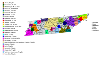
The U.S. State of Tennessee currently has 34 statistical areas that have been delineated by the Office of Management and Budget (OMB). On March 6, 2020, the OMB delineated 7 combined statistical areas, 10 metropolitan statistical areas, and 17 micropolitan statistical areas in Tennessee.[1]
Statistical areas
The Office of Management and Budget (OMB) has designated more than 1,000 statistical areas for the United States and Puerto Rico.[2] These statistical areas are important geographic delineations of population clusters used by the OMB, the United States Census Bureau, planning organizations, and federal, state, and local government entities.
The OMB defines a core-based statistical area (commonly referred to as a CBSA) as "a statistical geographic entity consisting of the county or counties (or county-equivalents) associated with at least one core[a] of at least 10,000 population, plus adjacent counties having a high degree of social and economic integration with the core as measured through commuting ties with the counties containing the core."[2] The OMB further divides core-based statistical areas into metropolitan statistical areas (MSAs) that have "a population of at least 50,000" and micropolitan statistical areas (μSAs) that have "a population of at least 10,000, but less than 50,000."[2]
The OMB defines a combined statistical area (CSA) as "a geographic entity consisting of two or more adjacent core-based statistical areas with employment interchange measures[b] of at least 15%."[2] The primary statistical areas (PSAs) include all combined statistical areas and any core-based statistical area that is not a constituent of a combined statistical area.
Table
The table below describes the 34 United States statistical areas and 95 counties of the State of Tennessee with the following information:[3]
- The combined statistical area (CSA) as designated by the OMB.[1]
- The CSA population according to 2019 US Census Bureau population estimates.[4]
- The core based statistical area (CBSA)[2] as designated by the OMB.[1]
- The CBSA population according to 2019 US Census Bureau population estimates [4]
- The county name
- The county population according to 2019 US Census Bureau population estimates [4]
| Combined Statistical Area | 2020 Population | Core Based Statistical Area | 2020 Population | County | 2020 Population | 2022 Population |
|---|---|---|---|---|---|---|
| Nashville-Davidson-Murfreesboro, TN CSA | 2,382,408 | Nashville-Davidson-Murfreesboro-Franklin, TN MSA | 2,072,283 | Davidson County, Tennessee | 715,875 | 708,144 |
| Rutherford County, Tennessee | 341,481 | 360,619 | ||||
| Williamson County, Tennessee | 247,733 | 260,815 | ||||
| Sumner County, Tennessee | 196,281 | 203,858 | ||||
| Wilson County, Tennessee | 147,747 | 158,555 | ||||
| Maury County, Tennessee | 100,975 | 108,159 | ||||
| Robertson County, Tennessee | 72,803 | 75,470 | ||||
| Dickson County, Tennessee | 54,314 | 55,761 | ||||
| Cheatham County, Tennessee | 41,065 | 41,830 | ||||
| Hickman County, Tennessee | 24,909 | 25,455 | ||||
| Macon County, Tennessee | 25,215 | 26,229 | ||||
| Smith County, Tennessee | 19,914 | 20,489 | ||||
| Cannon County, Tennessee | 14,512 | 14,788 | ||||
| Trousdale County, Tennessee | 11,610 | 12,111 | ||||
| Tullahoma-Manchester, TN μSA | 66,470 | Coffee County, Tennessee | 57,882 | 59,728 | ||
| Moore County, Tennessee | 6,469 | 6,742 | ||||
| Shelbyville, TN μSA | 51,950 | Bedford County, Tennessee | 50,239 | 51,950 | ||
| Lawrenceburg, TN μSA | 45,415 | Lawrence County, Tennessee | 44,163 | 45,415 | ||
| Winchester, TN μSA | 43,942 | Franklin County, Tennessee | 42,769 | 43,942 | ||
| Lewisburg, TN μSA | 35,878 | Marshall County, Tennessee | 34,320 | 35,878 | ||
| Knoxville-Morristown-Sevierville, TN CSA | 1,189,808 | Knoxville, TN MSA | 932,245 | Knox County, Tennessee | 478,981 | 494,574 |
| Blount County, Tennessee | 135,283 | 139,958 | ||||
| Anderson County, Tennessee | 77,136 | 78,913 | ||||
| Loudon County, Tennessee | 54,887 | 58,181 | ||||
| Roane County, Tennessee | 53,393 | 55,082 | ||||
| Campbell County, Tennessee | 39,277 | 39,584 | ||||
| Grainger County, Tennessee | 23,527 | 24,277 | ||||
| Morgan County, Tennessee | 21,027 | 21,224 | ||||
| Union County, Tennessee | 19,802 | 20,452 | ||||
| Morristown, TN MSA | 121,895 | Hamblen County, Tennessee | 64,500 | 65,168 | ||
| Jefferson County, Tennessee | 54,679 | 56,727 | ||||
| Sevierville, TN μSA | 98,789 | Sevier County, Tennessee | 98,391 | 98,789 | ||
| Newport, TN μSA | 36,879 | Cocke County, Tennessee | 35,998 | 36,879 | ||
| Memphis-Forrest City, TN-MS-AR CSA | 1,385,491 1,049,404 | Memphis, TN-MS-AR MSA | 1,339,855 1,029,207 | Shelby County, Tennessee | 929,722 | 916,371 |
| Benton County, Mississippi | 7,644 | 7,550 | ||||
| DeSoto County, Mississippi | 185,317 | 191,723 | ||||
| Tipton County, Tennessee | 60,979 | 61,656 | ||||
| Crittenden County, Arkansas | 48,169 | 47,061 | ||||
| Fayette County, Tennessee | 42,002 | 43,630 | ||||
| Marshall County, Mississippi | 33,755 | 34,110 | ||||
| Tate County, Mississippi | 28,066 | 28,296 | ||||
| Tunica County, Mississippi | 9,777 | 9,458 | ||||
| Clarksdale, MS μSA | 20,197 | Coahoma County, Mississippi | 21,393 | 20,197 | ||
| Forrest City, AR μSA | 25,439 | St. Francis County, Arkansas | 23,089 | 22,451 | ||
| Chattanooga-Cleveland-Dalton, TN-GA-AL CSA | 967,447 617,155 | Chattanooga, TN-GA MSA | 574,507 420,685 | Hamilton County, Tennessee | 366,215 | 374,682 |
| Walker County, Georgia | 67,742 | 68,915 | ||||
| Catoosa County, Georgia | 68,006 | 68,826 | ||||
| Marion County, Tennessee | 28,835 | 29,094 | ||||
| Dade County, Georgia | 16,235 | 16,081 | ||||
| Sequatchie County, Tennessee | 15,850 | 16,909 | ||||
| Dalton, GA MSA | 143,604 | Murray County, Georgia | ||||
| Whitfield County, Georgia | ||||||
| Cleveland, TN MSA | 128,479 | Bradley County, Tennessee | 108,820 | 110,616 | ||
| Polk County, Tennessee | 17,568 | 17,863 | ||||
| Athens, TN μSA | 67,991 | McMinn County, Tennessee | 53,344 | 54,719 | ||
| Meigs County, Tennessee | 12,755 | 13,272 | ||||
| Scottsboro, AL μSA | 52,891 | Jackson County, Alabama | 52,545 | 52,891 | ||
| Summerville, GA μSA | 24,936 | Chattooga County, Georgia | 24,922 | 24,936 | ||
| Johnson City-Kingsport-Bristol, TN-VA CSA | 592,913 500,524 | Kingsport-Bristol, TN-VA MSA | 311,252 218,863 | Sullivan County, Tennessee | 158,161 | 160,820 |
| Hawkins County, Tennessee | 56,718 | 58,043 | ||||
| Washington County, Virginia | 53,934 | 53,938 | ||||
| Scott County, Virginia | 21,568 | 21,476 | ||||
| City of Bristol, Virginia | 17,218 | 16,975 | ||||
| Johnson City, TN MSA | 204,044 | Washington County, Tennessee | 133,005 | 136,172 | ||
| Carter County, Tennessee | 56,349 | 56,410 | ||||
| Unicoi County, Tennessee | 17,924 | 17,674 | ||||
| Greeneville, TN μSA | 69,069 | Greene County, Tennessee | 70,152 | 71,405 | ||
| none | Clarksville, TN-KY MSA | 336,605 249,236 | Montgomery County, Tennessee | 219,994 | 235,201 | |
| Christian County, Kentucky | 72,818 | 73,037 | ||||
| Trigg County, Kentucky | 14,057 | 14,332 | ||||
| Stewart County, Tennessee | 13,662 | 14,035 | ||||
| Jackson, TN MSA | 181,579 | Madison County, Tennessee | 98,843 | 99,245 | ||
| Gibson County, Tennessee | 50,409 | 50,837 | ||||
| Chester County, Tennessee | 17,348 | 17,609 | ||||
| Crockett County, Tennessee | 13,909 | 13,888 | ||||
| Cookeville, TN μSA | 145,479 | Putnam County, Tennessee | 79,844 | 82,382 | ||
| White County, Tennessee | 27,356 | 28,064 | ||||
| Overton County, Tennessee | 22,514 | 23,044 | ||||
| Jackson County, Tennessee | 11,619 | 11,989 | ||||
| Crossville, TN μSA | 63,522 | Cumberland County, Tennessee | 61,152 | 63,522 | ||
| Union City-Martin, TN CSA | 63,457 | Martin, TN μSA | 33,063 | Weakley County, Tennessee | 32,902 | 33,063 |
| Union City, TN μSA | 30,394 | Obion County, Tennessee | 30,788 | 30,394 | ||
| none | McMinnville, TN μSA | 42,026 | Warren County, Tennessee | 40,951 | 42,026 | |
| Dyersburg, TN μSA | 36,410 | Dyer County, Tennessee | 36,803 | 36,410 | ||
| Huntsville-Decatur-Albertville, AL-TN CSA | 879,315 36,004 | Huntsville, AL, MSA[c] | 514,465 | |||
| Decatur, AL, MSA[d] | 157,425 | |||||
| Albertville, AL, MSA | 99,423 | |||||
| Fort Payne, AL, MSA | 71,998 | |||||
| Fayetteville, TN μSA | 36,004 | Lincoln County, Tennessee | 35,326 | 36,004 | ||
| none | Paris, TN μSA | 33,730 | Henry County, Tennessee | 32,870 | 33,730 | |
| Brownsville, TN μSA | 17,550 | Haywood County, Tennessee | 17,862 | 17,550 | ||
| none | Monroe County, Tennessee | 46,249 | 47,740 | |||
| Rhea County, Tennessee | 32,197 | 32,379 | ||||
| Claiborne County, Tennessee | 32,038 | 32,431 | ||||
| Giles County, Tennessee | 30,344 | 30,554 | ||||
| Henderson County, Tennessee | 27,841 | 27,929 | ||||
| Carroll County, Tennessee | 28,434 | 28,458 | ||||
| McNairy County, Tennessee | 25,859 | 25,988 | ||||
| Hardin County, Tennessee | 26,829 | 27,077 | ||||
| Lauderdale County, Tennessee | 25,139 | 24,793 | ||||
| Hardeman County, Tennessee | 25,460 | 25,529 | ||||
| Scott County, Tennessee | 21,852 | 22,035 | ||||
| DeKalb County, Tennessee | 20,078 | 21,003 | ||||
| Humphreys County, Tennessee | 18,992 | 19,106 | ||||
| Fentress County, Tennessee | 18,489 | 19,332 | ||||
| Johnson County, Tennessee | 17,950 | 18,086 | ||||
| Wayne County, Tennessee | 16,232 | 16,308 | ||||
| Benton County, Tennessee | 15,863 | 16,002 | ||||
| Bledsoe County, Tennessee | 14,916 | 14,798 | ||||
| Grundy County, Tennessee | 13,525 | 13,783 | ||||
| Lewis County, Tennessee | 12,581 | 12,957 | ||||
| Decatur County, Tennessee | 11,442 | 11,564 | ||||
| Houston County, Tennessee | 8,281 | 8,219 | ||||
| Perry County, Tennessee | 8,381 | 8,685 | ||||
| Clay County, Tennessee | 7,580 | 7,620 | ||||
| Lake County, Tennessee | 7,004 | 6,507 | ||||
| Hancock County, Tennessee | 6,659 | 6,845 | ||||
| Van Buren County, Tennessee | 6,168 | 6,429 | ||||
| Pickett County, Tennessee | 5,006 | 5,107 | ||||
| State of Tennessee | 6,910,786 | 7,051,339 | ||||
See also
 Geography portal
 United States portal
 Tennessee portal


Notes
- ^ The OMB defines a core as "a densely settled concentration of population, comprising an Urban Area (of 10,000 or more population) delineated by the Census Bureau, around which a core-based statistical area is delineated."[2]
- ^ The OMB defines the employment interchange measure as "the sum of the percentage of workers living in the smaller entity who work in the larger entity plus the percentage of employment in the smaller entity that is accounted for by workers who reside in the larger entity."[2]
- ^ Consists of Limestone and Madison counties, AL
- ^ Consists of Lawrence and Morgan counties, AL
References
- ^ a b c d Revised Delineations of Metropolitan Statistical Areas, Micropolitan Statistical Areas, and Combined Statistical Areas, and Guidance on Uses of the Delineations of These Areas (July 21, 2023). "0MB BULLETIN NO. 23-01" (PDF). Office of Management and Budget. Retrieved October 23, 2023.
{{cite web}}: CS1 maint: multiple names: authors list (link) - ^ a b c d e f g "2020 Standards for Delineating Core Based Statistical Areas". Office of Management and Budget. July 16, 2021. Retrieved December 15, 2021.
- ^ An out-of-state area and its population are displayed in green. An area that extends into more than one state is displayed in teal. A teal population number over a black population number show the total population versus the in-state population.
- ^ a b c "County Population Totals and Components of Change: 2020-2022". United States Census Bureau, Population Division. March 2023. Retrieved October 10, 2023.
External links
Tennessee at Wikipedia's sister projects
 Media from Commons
 News from Wikinews
 Quotations from Wikiquote
 Travel information from Wikivoyage
- Office of Management and Budget
- United States Census Bureau
- v
- t
- e
- Alabama
- Alaska
- Arizona
- Arkansas
- California
- Colorado
- Connecticut
- Delaware
- Florida
- Georgia
- Hawaiʻi
- Idaho
- Illinois
- Indiana
- Iowa
- Kansas
- Kentucky
- Louisiana
- Maine
- Maryland
- Massachusetts
- Michigan
- Minnesota
- Mississippi
- Missouri
- Montana
- Nebraska
- Nevada
- New Hampshire
- New Jersey
- New Mexico
- New York
- North Carolina
- North Dakota
- Ohio
- Oklahoma
- Oregon
- Pennsylvania
- Rhode Island
- South Carolina
- South Dakota
- Tennessee
- Texas
- Utah
- Vermont
- Virginia
- Washington
- West Virginia
- Wisconsin
- Wyoming
- Primary statistical areas
- Combined statistical areas
- Metropolitan statistical areas
- Micropolitan statistical areas
35°51′29″N 86°21′02″W / 35.8580°N 86.3505°W / 35.8580; -86.3505 (State of Tennessee)


